- Home
- :
- All Communities
- :
- Products
- :
- ArcGIS Survey123
- :
- ArcGIS Survey123 Questions
- :
- Re: Problem adding custom basemap to Survey123
- Subscribe to RSS Feed
- Mark Topic as New
- Mark Topic as Read
- Float this Topic for Current User
- Bookmark
- Subscribe
- Mute
- Printer Friendly Page
Problem adding custom basemap to Survey123
- Mark as New
- Bookmark
- Subscribe
- Mute
- Subscribe to RSS Feed
- Permalink
UPDATE for anyone who has the same question I did: I found out that it is not currently possible to add a Pictometry/Eagleview imagery basemap to Survey123.
-------------------------------------------------------------------------------------------------------------------------------------------------------
ORIGINAL POST:
I need to add my organization's aerial imagery basemap to a survey I created using Survey123 Connect, but I'm running into problems--my changes to the .info file totally disappear when I re-publish the survey.
I already read a couple of GeoNet threads about this, plus this Esri page: Prepare basemaps for offline use—Survey123 for ArcGIS | ArcGIS and this one: Include a map in your survey—Survey123 for ArcGIS | ArcGIS
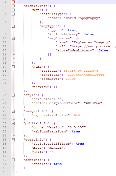
The .info file associated with my survey seems a little different from the sample on the above webpages, in that mine includes a line about the default map (I want my default to be World Topography, but I want my own aerial imagery to be an option that the users can select when using the survey). So I had to make a wild guess about where to place my "mapTypes" section. Maybe this is part of the problem?
Here is my .info file with my custom basemap added into it. I checked the syntax online with JSONLint, which was very helpful. Nothing in my survey/settings "breaks" when I try to use this .info, but the problem is that my desired basemap is not added in any way at all, and when I go to check on the .info file after re-publishing my survey, the .info file has gone back to how it was before I added my custom basemap! The stuff I added simply disappears (the "mapTypes" section). How do I get it to stick??
(Note: my URL is complete; it appears incomplete below due to where my screenshot cut it off.)
- Mark as New
- Bookmark
- Subscribe
- Mute
- Subscribe to RSS Feed
- Permalink
Hi Allen,
When modifying the .info file Connect must be closed and the file not in use, otherwise it will revert back to previous. Modify and save the file and then open Connect again and re-publish.
For the 3.6 release we are introducing additional support for basemaps and web maps via Linked Content and improved online and offline map support. You can check out the current support for additional map types on EAC here.
Regards,
Phil.
- Mark as New
- Bookmark
- Subscribe
- Mute
- Subscribe to RSS Feed
- Permalink
Thank you, Phil!
I tried out what you suggested - modifying the .info file while Connect was closed. It worked more than before, but not completely: My custom basemap name appeared in the list of basemaps (in the form preview in Connect), but the survey style/color and default map location were erased.
Also, my custom basemap did not show up in the map viewer, even though the name was in the basemap list, but this is probably not Survey123's fault; my supervisor was told by Pictometry (the company that made the imagery basemap I want to use) that their imagery can't be connected to Survey123.
Thanks for the EAC link - sounds like cool stuff is in the works.
We are going to put off dealing with this custom basemap issue till sometime in the future, since there seems to be an issue on our imagery supplier's end, as I mentioned.
Thanks again!
Allen