- Home
- :
- All Communities
- :
- Products
- :
- ArcGIS Survey123
- :
- ArcGIS Survey123 Questions
- :
- mmpk reverts to full extent
- Subscribe to RSS Feed
- Mark Topic as New
- Mark Topic as Read
- Float this Topic for Current User
- Bookmark
- Subscribe
- Mute
- Printer Friendly Page
- Mark as New
- Bookmark
- Subscribe
- Mute
- Subscribe to RSS Feed
- Permalink
Hi All
I have created an mmpk of a certain area of my state with some wetlands for context and added it to the media folder in survey123 connect. It published and downloaded to the device without any issue.
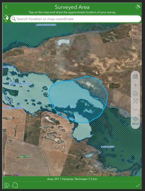
I can click on the map in the geoshape question and zoom in to draw an area for capture
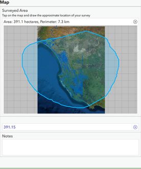
However after I click on the tick/OK the map reverts back to the full extent in the geoshape question
The geometry, extent and area still seem ok ...but it look weird in relation to the full extent of the map.
If I click back on the geoshape question the map displays correctly as per the first image, Its just seems to be the preview/display thats not right
Any ideas on whats happening here?
Cheers
Chris
Solved! Go to Solution.
Accepted Solutions
- Mark as New
- Bookmark
- Subscribe
- Mute
- Subscribe to RSS Feed
- Permalink
Hi @ChrisRoberts2,
Thanks for sending me your xlsx file and the mmpk file (via email). I am able to reproduce with 3.12 release the issue you are seeing with the preview map, it appears to display the extent of the mmpk instead of the map area of the mmpk that the geoshape is located.
The good news is that with the 3.13 beta builds available on the Early Adopter Community the issue appears to be resolved. We recently made some improvements and fixes to the map preview and map display, which has also resulted in fixing the issue with mmpk map extents. Please test out the latest 3.13 beta and let us know if you have any further issues.
Regards,
Phil.
- Mark as New
- Bookmark
- Subscribe
- Mute
- Subscribe to RSS Feed
- Permalink
Hi @ChrisRoberts2,
Can you confirm what version of Connect and field app you are using?
Also, can you share the mmpk and the xlsx file used for this survey?
Regards,
Phil.
- Mark as New
- Bookmark
- Subscribe
- Mute
- Subscribe to RSS Feed
- Permalink
Thanks @Anonymous User
I am using Connect 3.12.232 and app 3.12.277
The survey is still a work in progess but the relevant geoshape question is at the very bottom.
I cant attach the mmpk as its to big for upload here.
However a weird thing I noticed if that if I go back into the geshape questions again (after I created a shape), and recapture it then the priew/question extent remains to the area captured.
- Mark as New
- Bookmark
- Subscribe
- Mute
- Subscribe to RSS Feed
- Permalink
Hi @ChrisRoberts2,
Thanks for sending me your xlsx file and the mmpk file (via email). I am able to reproduce with 3.12 release the issue you are seeing with the preview map, it appears to display the extent of the mmpk instead of the map area of the mmpk that the geoshape is located.
The good news is that with the 3.13 beta builds available on the Early Adopter Community the issue appears to be resolved. We recently made some improvements and fixes to the map preview and map display, which has also resulted in fixing the issue with mmpk map extents. Please test out the latest 3.13 beta and let us know if you have any further issues.
Regards,
Phil.

