- Home
- :
- All Communities
- :
- Products
- :
- ArcGIS Survey123
- :
- ArcGIS Survey123 Questions
- :
- Re: Making changes to data
- Subscribe to RSS Feed
- Mark Topic as New
- Mark Topic as Read
- Float this Topic for Current User
- Bookmark
- Subscribe
- Mute
- Printer Friendly Page
Making changes to data
- Mark as New
- Bookmark
- Subscribe
- Mute
- Subscribe to RSS Feed
- Permalink
I need to change the Lat and Lon on some of my map points because they are way off. How do I do that without having to download a CSV file?
- Mark as New
- Bookmark
- Subscribe
- Mute
- Subscribe to RSS Feed
- Permalink
The easiest way would be to open the layer in the ArcGIS Online Map Viewer and edit the points there.
- Mark as New
- Bookmark
- Subscribe
- Mute
- Subscribe to RSS Feed
- Permalink
Hi James, could you be more specific, please?
- Mark as New
- Bookmark
- Subscribe
- Mute
- Subscribe to RSS Feed
- Permalink
If you open the survey in survey123.arcgis.com, go to the 'Data' tab. There you should see a button at the lower left to 'Open in ArcGIS Map Viewer'.
- Mark as New
- Bookmark
- Subscribe
- Mute
- Subscribe to RSS Feed
- Permalink
Yes, but how do I edit the coordinates?
- Mark as New
- Bookmark
- Subscribe
- Mute
- Subscribe to RSS Feed
- Permalink
you should see a button marked 'edit' in the map viewer- clicking that will allow you to edit the data. See Edit features—ArcGIS Online Help | ArcGIS for more information.
- Mark as New
- Bookmark
- Subscribe
- Mute
- Subscribe to RSS Feed
- Permalink
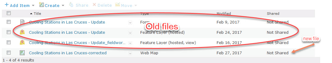
I made the changes to the coordinates but now what should I do with the old files?
- Mark as New
- Bookmark
- Subscribe
- Mute
- Subscribe to RSS Feed
- Permalink
Hi randee,
What you are showing in the image aren't "old files"- all are current and part of your survey. By item type, they represent:
- The Form is the file that describes they survey and questions for the web & mobile Survey123 clients
- The Feature Layer items represent where the survey data is stored.
- The one that is just (hosted) is the original access point for the data and should be kept private to the author of the survey
- The one that ends with "_fieldworker" is used as the submitting/editing endpoint - it's what the website and mobile application connect to when filling in the survey
- The Web Map item is a graphical view of the data you created while or after editing the survey data. It doesn't store the survey data; rather, it accesses the survey data from one of the 2 Feature Layer items mentioned above.