- Home
- :
- All Communities
- :
- Products
- :
- ArcGIS Survey123
- :
- ArcGIS Survey123 Ideas
- :
- Enable selection and pop-ups in survey maps
- Subscribe to RSS Feed
- Mark as New
- Mark as Read
- Bookmark
- Follow this Idea
- Printer Friendly Page
Enable selection and pop-ups in survey maps
- Mark as New
- Bookmark
- Subscribe
- Mute
- Subscribe to RSS Feed
- Permalink
It would be nice to be able to select features from the Survey123 map and view a pop-up. Currently, you can created a customized basemap with map layers and view the map in Survey123. However, the map layers in the basemap act just as a reference and you cannot select them and review a pop-up. It would be helpful if the user was able to select an item in the map and review a configured pop-up, just like you can in Collector. For users in the field, being able to review pertinent information in a pop-up would help them complete the survey.
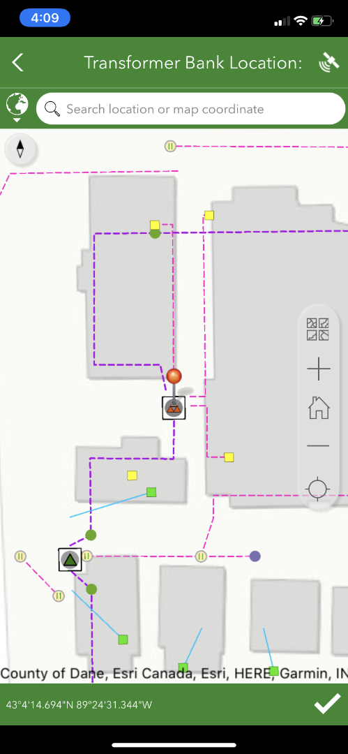
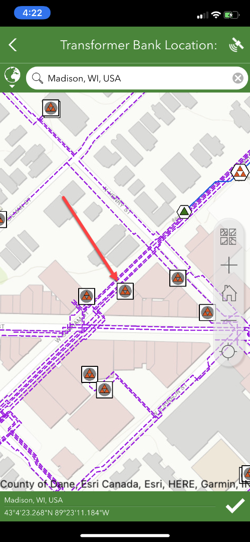
For example, below is a custom basemap that was added to an inspection survey. The map provides a great reference to the field user but the map elements are not selectable and you cannot get any information from them. It would be great if the user was able to select an item from the map (such as a transformer) and see a pop-up of the selected item. The pop-up might provide additional information that would aid the field user in completing the survey.
- « Previous
-
- 1
- 2
- 3
- Next »
I would also love the ability to select an item in the map on Survey123, either to show a pop up or what I would also like to see is being able to set it up so when you select an asset it can take the attributes to fill in questions in the form (e.g. an Asset ID).
As mentioned above there is the option of going from an app like Field Maps using the custom URLs but I have to agree for the field users it definitely comes across as cumbersome having to use both apps. I've also run into issues with the coordinate information being passed incorrectly and have never been able to figure out why even with Esri Support, so it all being within the same app ecosystem would be a lot smoother.
Any progress with this? Currently using the Field Maps to S123 App integration workflow for Maritime Inspections. I don't think that Field Maps has anywhere the same smart form technology and logic as is available in S123 Connect.
Hopefully someone can provide a future update? @DerekLaw
Hi @SimonAllard2,
Apologies for the late reply.
Unfortunately, I am not in a position to comment on this item as I don't work closely with the ArcGIS Survey123 Dev team. Looping in @Ismael and @JamesTedrick for comments.
+1 on the idea of either:
- Maps within Survey123 support popups, like normal webmaps, and/or
- Selection of features from a map within Survey123 Populates values (this way a user might not need a popup, but instead taps a feature which populates some read-only note fields to act like a popup under the map)
Just checking to see if there has been any updates with this? I too am working to provide a way for selected features from a webmap to populate fields in a survey. Will require less back and forth between the two apps.
Unsure if this is related, but I have come across an issue on touch screen when trying to select a map point/feature on Survey123 Web. Using the calculation function I am able to populate the survey fields based on the map layer, however it seems that the point can only be selected (snapped) when using a mouse and does not work when a user touches the screen. Is this a current limitation of Survery123 Web?
Screen recording attached for example:

Has there been any update to adding the pop ups functionality add to S123 maps?
Pop-Up functionality is still not present if you have a geopoint question in your survey. Disappointed users cannot see the details for submitted surveys through pop-up. Would have been such a great addition for field users. Does not appear ESRI intends to develop.
This is also vital for our use, a very large organization. Users in the field must be able to research what they are looking at in complex and unfamiliar areas. The basic principle of GIS is the relationship between a geographic feature and its attributes and vice versa. It is surprising that this most basic of concepts is not possible on a S123 map. Not only is the concept of geom<=>attrib pretty basic, but there are other issues that make this vital. For instance, as others have mentioned, linking over to another application for simple information is cumbersome to the end user, but it is also to the rest of the organization and implementation as a whole. To the developer of the survey, they now need to author and prep two interfaces, which often also includes training, documentation etc of what is happening and how users need to use it. Instead of just authoring one survey and telling the users 'if you need to know what a feature on the map is, click this button', it becomes a whole complex thing. Also, now there is more management of maps and services to author and maintain. Then, our organization, is required to submit applications for security review, testing and finally packaging in our own secure installation wrapper, which is a lengthy process, even for just S123. Having two applications, instead of just S123, doubles that already cumbersome effort and each time a new release happens, this must be re-addressed each time. Also, for offline surveying, two separate packages are then also likely required to be authored then downloaded at survey time....one for the S123 map and another for Collector (which is no longer supported) or FieldMaps or some other option (if there is one) that offers Identify/Popup functionality and offline capability. Plus, FM cant be the link-to-Identify option because we do have a requirement to support many users in Windows, so I dont think there is an option to link to another app for the Identify functionality, that would support all of our users, that is. At least not in the required offline scenario. We have traditionally already had, at times, sporadic issues pulling download packages (for Collector) during disaster events where there is often network instability, a high volume of users & urgency to get in the field, so doubling that load is likely undoable for the users and also the backend portal and servers, and is just inefficient, even if it worked every time. We love the way S123 works, and unfortunately cant just switch to the next best option, FieldMaps, due to the need to support users in Windows environments, as well. This just seems to be a really complex, unnecessary and problematic set of solutions (maybe with no viable solution) and obstacles to deal with, just to get around the limitation of the most basic concept of GIS. @Ismael, @JamesTedrick
Has this been addressed?
I'm not getting the results I need or want and this would be SO simple.
Instead, I have an ExB created that has a map that shows the layer everyone is submitting pins to through Survey123 and then the survey in a window beside it where they actually submit pins. Its not ideal, but is a fine workaround. Everything would be so much easier if folks could fully interact with the map that is within the Survey123.
You must be a registered user to add a comment. If you've already registered, sign in. Otherwise, register and sign in.