- Home
- :
- All Communities
- :
- Products
- :
- ArcGIS Survey123
- :
- ArcGIS Survey123 Ideas
- :
- Allow custom map scale as optional parameter for g...
- Subscribe to RSS Feed
- Mark as New
- Mark as Read
- Bookmark
- Follow this Idea
- Printer Friendly Page
Allow custom map scale as optional parameter for geoshape and geotrace questions in report for Survey123
- Mark as New
- Bookmark
- Subscribe
- Mute
- Subscribe to RSS Feed
- Permalink
The idea is to have the same possibilty as for geopoint to add a custom scale when printing the map in the report.
Current situation:
The scale is automatically based on the extent of the feature. This is to make sure that the entire feature is displayed in the map. It is impossible to set a custom scale as for geopoints.
Issue:
For any extent smaller than few km², which happens most of the time I assume, the scale will be too large to give any information about the location and the surroundings. As a result the map becomes rather unuseful (apart from giving a shape of the feature).
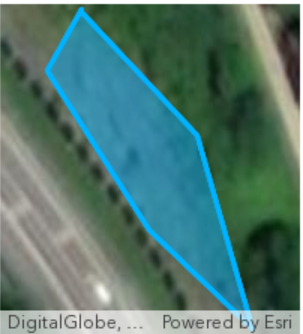
Example:
The image below shows an example of geoshape export. From this image, our client cannot have any clue of where this feature is located within the 3'000 km² of the area of study: we lose the spatial information and the science of where.
Suggestions:
- Let the user set the scale as an optionnal parameter, but somehow add a warning that the entire feature might not be comprised in the map if the scale is to large. It is therefore to the user to take the responsability to set a custom scale or let it by default.
- Calculate automatically the scale in the report as max("feature extent scale", user-defined scale)
- Add an option to map the centroid of the shape instead of the shape itself (not necessarily the best option, neither the easiest to implement I guess)
Link to the initial thread.
Even though it was probably thought to avoid any unfortunate behavior, I do believe that "preventing" by "restricting" is not the good way here. Let the user the choice to take the risk ! Not much to lose in this case...
Great Idea! There are a few scenarios where I would want to tweak/expand the extend of my GeoShape. Also, as the OP notes - it would be nice to add a second overview map that shows at a larger scale to give you an overall idea of where the location is. Some of our survey geoshapes are very small and you don't get a great handle on where they are. A locus map would be a huge benefit.
The suggestion of showing the centroid of the geoshape at a larger scale is a great one!
You must be a registered user to add a comment. If you've already registered, sign in. Otherwise, register and sign in.