Survey123 Tricks of the Trade: Configuring survey maps

29682
33
08-06-2020 06:27 PM
IsmaelChivite
Esri Notable Contributor
15 33 29.7K

[Last updated April 2022]


Take a look at the two Survey123 projects below, both of them use custom maps. The Hydrant Maintenance form on the left uses a map showing the water network as well as color coded hydrants indicating the status of the last inspection performed in them. The hydrants are also labeled indicating both their Asset ID as well as the date of the last inspection performed. The Violation Report project on the right, combines an Esri Topographic basemap with a couple of feature layers: one representing parcel boundaries in blue, and one highlighting existing violation reports within the last year. Using Survey123 web or field app, it does not matter, you can always decide what map is best for the end users of your smart form.
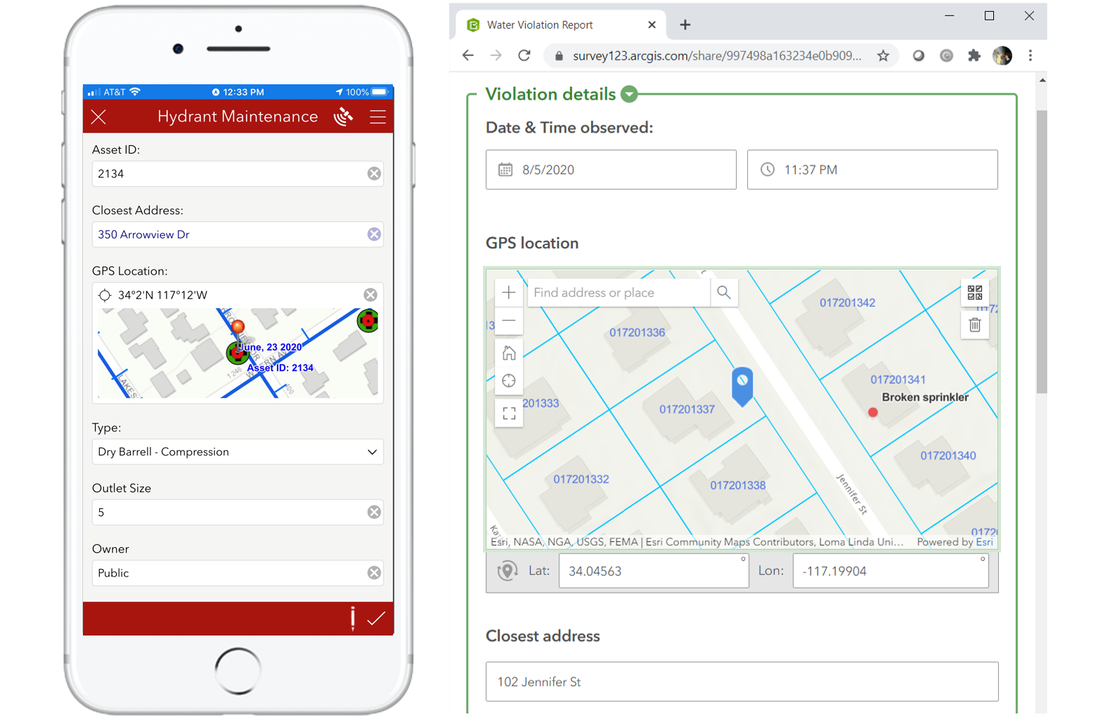


Configuring the right map for the workflow at hand is important to provide the best possible experience to end users. The map used in the Hydrant Maintenance form helps users validate if the hydrant they are inspecting is in fact the one that should be inspected. The map provides good geographic context. It also gives a visual indication of when hydrants were inspected for the last time. The Violation Report map helps more clearly identify to which property the violation found belongs and if other violations have been reported in the area in the past.

To specify a custom map for your survey, you can use Survey123 designer or Survey123 Connect.


Setting a default custom map in Survey123 designer


If you created your survey in the web designer, you are just a few click away. Watch this animation for details:

Custom Map Designer.gif


Note that you can choose between any of the organization basemaps, but also a custom web map you may have created or shared with you.


Setting a default custom map in Survey123 Connect


In Survey123 Connect, select a published survey and navigate to your Survey Settings -> Map tab. The map gallery will display choices from your organization Survey123 basemap. While the default map selected is set at the organization, as a survey author you can override it by selecting another one from the list.


Most importantly, if you switch to the Linked Content tab you will be able to link your survey with other maps, specific to your project. Linked maps will also show in the survey map gallery. You can also select any of the linked maps as the default map of your survey.


Lets do this step by step:


  • In Survey123 Connect, select a survey and click on survey Settings
  • Click on Linked Content and link a map
  • Optionally, go to the survey Map tab, open the map gallery and select your linked map as the default map, then publish for the default map change to take effect. Note: If you go into the Map tab and you cannot see a recently linked map in it, reopen Survey123 Connect to refresh the map gallery.


IsmaelChivite_0-1650477322427.png

You can also specify the map to be loaded in a geopoint, geotrace or geoshape question by specifying the itemId of your map in the body:esri:style XLSForm. When you take this approach, the map you choose must be previously linked to your survey. This is how you do it:

IsmaelChivite_0-1635468010718.png


Understanding the Survey123 app map gallery


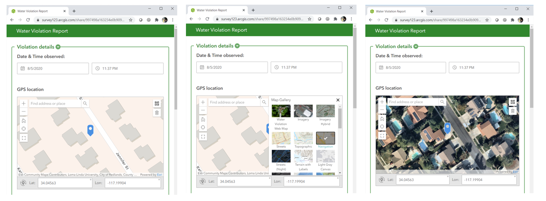
When a user interacts with a map in any of the Survey123 apps (web or field), a map gallery (aka basemap switcher) is available for users to choose what map should be displayed. The illustration below shows that the map gallery can be accessed from the top-right corner of the map in the Survey123 web app. Once opened, the user selects the map to be shown.
The experience in the Survey123 field app is very similar. Below you can see that the end user has opened the Inbox map to look at all the hydrants that have been assigned for inspection today. The map gallery can be accessed to switch the map at any time.
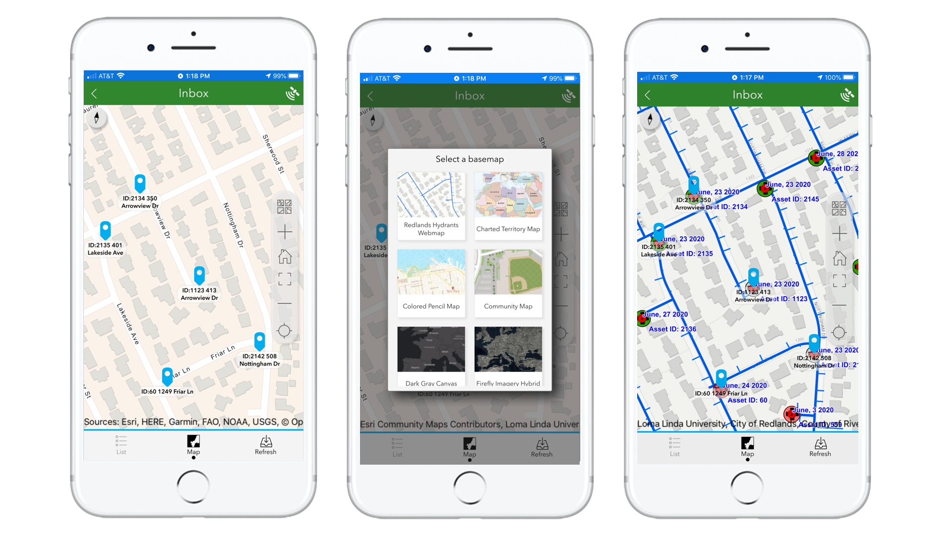
 

The collection of maps in the gallery, is the combination of two sets: the collection of organization basemaps, and a collection of maps linked to the specific survey. 


Organization Basemaps


Organization basemaps are, no surprise, defined at the ArcGIS organization level and as such, they apply to all Survey123 projects. These are basemaps that will be made available, always, to all Survey123 users through the map gallery.


Traditionally, Survey123 pulled the list of maps from the basemap gallery defined at the ArcGIS (Online or Enterprise) level. However, in practice this may not quite work because often the collection of basemaps that makes sense to users of other ArcGIS apps, is not appropriate for Survey123 users. Starting with version 3.10, we introduced a new Survey123 specific organization setting so you can control the contents of the Survey123 basemap collection in the organization. This setting is honored by the Survey123 field app in 3.10 and will be also honored by the Survey123 web app in 3.11. 


Generally speaking, you do not want to include many basemaps at the organization level. One or two at most should do for the vast majority of cases. For context, the standard basemap gallery that comes predefined with ArcGIS Enterprise and ArcGIS Online has more than 20 choices. Definitively way too many for the average Survey123 end user. So many basemaps make sense for someone authoring a web map, but not for someone completing a built-for-purpose form. 


To create your own custom Survey123 organization basemap gallery:


  • Login into your ArcGIS organization with a user with administrative privileges.
  • Create a new Group in ArcGIS.
  • Share web maps with that group, ensuring that the web maps are also shared with Everyone, or at the very least with all users within your organization.
  • Login into the Survey123 website. You should see an Organization tab (only administrators see this tab).
  • Click on Organization and then activate the organization Settings tab.
  • Choose the group from which the maps should be shown and optionally the default map.
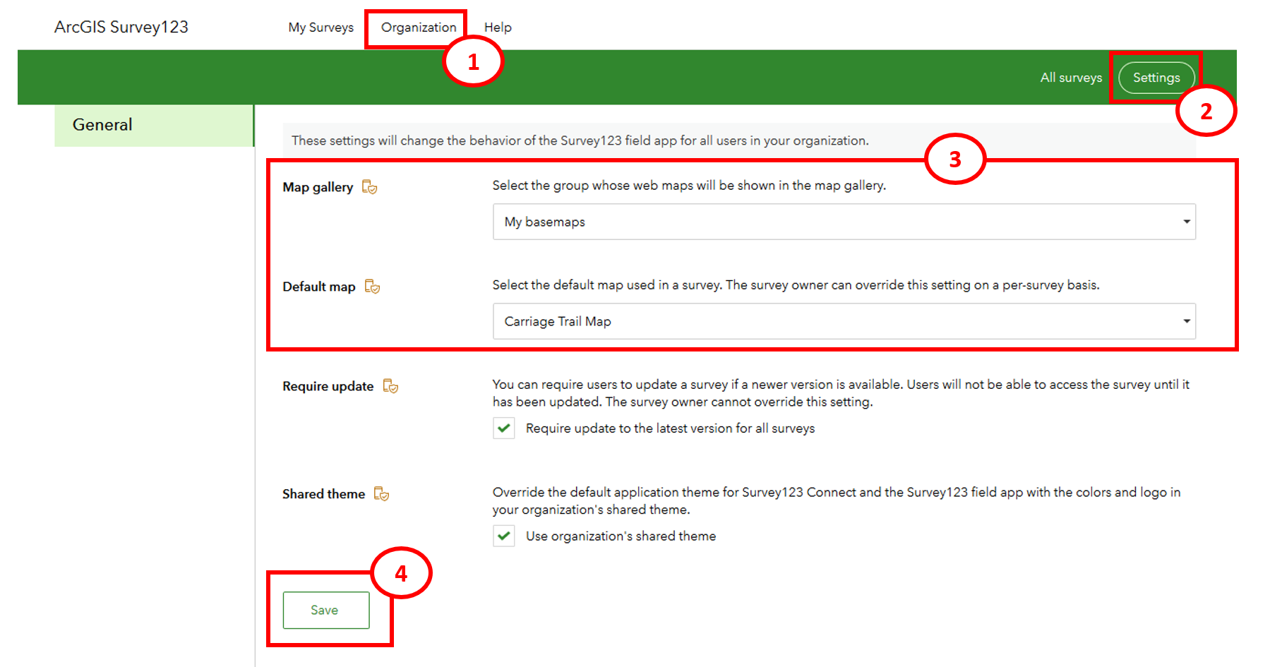
 

It is ultimately your call, but generally speaking, one or at most two maps in this group should probably do. Keep in mind that these maps will be shown in all surveys, so you really want to keep the list to a minimum.


Survey Basemaps


In addition to the maps set by the ArcGIS administrator in the Survey123 organization basemap gallery setting, survey authors can optionally add maps to their own surveys. This is done through Survey123 Connect.


Before we finish, just a few additional notes and considerations for Survey123 Connect users:


  • Before you can link a map to your survey, you must first publish the survey. It is not possible to link maps to a survey that is not published.
  • Once you link a map using Survey123 Connect, you do not need to republish the survey for end-users to see the new map. However, if you want your linked map to also be the default map of the survey, then you need to re-publish.
  • You can link web maps, and also vector tile packages and mobile map packages. Now, if you link offline maps, then end users will need to manually download those linked maps before they can be used. Linked offline maps do not get automatically downloaded when the survey is downloaded or refreshed in the field app.
  • You are responsible for ensuring that linked maps have been consistently shared with your end users. For example, if you link a map that is not shared with Group A, and you share your survey with Group A, then people in that group will be able to use your survey but not access your linked map. You can, of course, take this to your own advantage For example, if you work with users in 5 separate regions, it may make sense for you to share a single survey with all of them, link the corresponding 5 regional maps and share your linked apps accordingly so only users will only see maps for their own region.
33 Comments
PatriciaAlgura
New Contributor III

Hi Ishmael,

Looking forward to using this in 3.10. Does this also support that if I have a map with point features and I tap on the feature, the geopoint will actually snap to the feature point location I tapped and get the same location?

by Anonymous User
Not applicable

Hi Patricia,

No, it is not currently possible to select a feature (or snap to a feature) in the linked web map or vector basemap being used as the geopoint basemap.

Regards,

Phil.

PatriciaAlgura
New Contributor III

Thanks Phil,

Just thinking it would nice to have. Hopefully in the next Survey123 releases

Aurelija_RutaViluckyte
New Contributor III

Hello Ismael Chivite's Blog‌ , Thanks for letting us know the updates in detail. 

Regarding the custom basemaps to use in Survey123 surveys for users.

1) If I am not the administrator of the organization, but I am an author of the Survey123 (Connect). Can I Link my published webmap (custom basemap) from ArcGIS Portal to Survey123 Connect? Do I need any other "permissions"?

2) Does this also mean that when printing Feature Reports, this custom basemap will be printed out for geopoints? In Feature Reports I need to specify the webmap item id as far as I remember. Is there anything else I should take into attention?

Will be looking forward to your answers, thanks a lot in advance!

Aurelija

by Anonymous User
Not applicable

Hi Aurelija,

To answer your questions:

1) Provided the user that you are signed into Connect with (as the author) has permission and access to the published web map and the feature layers in the web map, it will be able to be linked to the survey and display as expected.

2) Yes, the same web map will be able to be displayed in Feature Reports, you will need to specify the web map itemid in the feature report if you want it set by default.

Regards,

Phil.

Aurelija_RutaViluckyte
New Contributor III

Thank you Philip, and I have one more question. 

So the user who created the webmap has shared this webmap and all the layers with me on the Portal. 

I am able to link this webmap into the Survey123 Connect app and see it as well as print it inside the Feature Reports. 

However, we cannot see one layer from the webmap which is an Orthophoto taken from WMS. Is this a limitation of Survey123 custom basemaps feature or is there something that we might be doing wrong?

The cadastral map and orthophoto comes from this WMS: 

https://services.kortforsyningen.dk/service?servicename=forvaltning&version=1.1.1&token=cf308b752430... 

And the cadastral map is visible, but not the orthophoto, as in the examples below:

Screenshot of webmap from Portal:

Screenshot from linked same webmap in Survey123 Connect:

And another issue, but not that critical, is that the linked webmaps are loading pretty slowly in Survey123 Connect app and sometimes I need to close the app and start again to even see the chosen webmap. Basically swtiching from one linked webmap to another linked webmap is pretty tricky-slow. 

Any input from your side is highly valued!

Aurelija

by Anonymous User
Not applicable

Hi Aurelija,

Is the layer you are not seeing a tiled image layer, if so, this is currently not supported. We have an issue in our backlog to support tiled image layers in the future, as there is an underlying limitation in the runtime currently.

As for the slow loading, this will depend on how many layers and how much data is included in the web map. You will likely notice the same slowness with these web maps using other ArcGIS runtime based apps.

Regards,

Phil.

GafoorMuhamad
New Contributor

Hi Phil, 

my question is related to custom basemaps in Survey123

I have a survey that require collecting Slope and Aspect information in the field. If I use custom base map and have Slope and Aspect layers on to my map. then make it default map for this survey, then is it possible for users to query the values of Slope and Aspect from the map and populate it survey questions?

by Anonymous User
Not applicable

Hi Gafoor,

No, it is not possible to query layers in the web map used as the basemap, it is simply a display only.

Regards,

Phil.

LukeThornton
New Contributor

Hi Phil - 

I finally have an excuse to try this out, but I am running into a problem ...

I was able to follow Ismael's instructions and my custom basemap is displaying in Connect on my desktop as expected.  However, when accessing the same survey on my iphone the map won't load.  (I see the basemap and I can select it, but I get an empty gray screen.)

Do you guys gave any experience with this issue? 

Thanks

Luke

Anneka_France
Occasional Contributor III

Hi @PatriciaAlgura and @Anonymous User,

We'd also like to be able to snap to feature in the survey map. I've added this as an idea: Select a feature (or snap to a feature) in a linked web map

Please upvote!

Hussam_AlJabri
Occasional Contributor III

Thanks for the post. I'm wondering if we can pull data into certain question just like from URL Scheme in the basemap.

WilliamBoswell
New Contributor II

We are creating a public Survey to be edited through a browser. This survey includes a base map (created from a web map) but it is only able to be seen by those who are signed into their ArcGIS Online accounts. The majority of the survey users do not have an ArcGIS Online account. I believe we have set everything to public...

Any tricks you know of to get this to work for the non-ArcGIS Online users?

RyanBohan
Occasional Contributor III

Is it possible to disable the base map gallery?  I have a public survey123 with a custom basemap loaded.  If the user changes basemaps they will also lose all the information included in the layers configured for the custom basemap.

For that reason I would like to disable the option to change the basemap for the geoshape/geopoint question.

JasminePrater
Occasional Contributor

I have a Dashboard set up like this, but I have embedded a blank survey in addition to the editable survey, and an embedded map that is a web app version of my map for access to Widgets.  I am not certain I need the embedded map for what I'm trying to do, but I've tried many things without luck.

What I need to do is select one or more assets from multiple feature services in my map (e.g., a fire hydrant, hydrant valve, and the pipe between), add their Global IDs, Work Order IDs, and one or two other fields from their respective tables, and add that information to the surveys embedded in the Dashboard.

Ultimately, what our utilities managers would like to be able to have is all Work Order IDs and Work Types displayed when they click on an asset.  Both of those fields are created in the survey, but I have no way to pass that information to the individual assets, or vice versa.  I would prefer they did not have to do this manually, as many people will need to be able to create Assignments and even remotely complicated will be rejected.

Does anyone have any suggestions as to how I might relate the Assignment/Work Order information to all assets that are being affected by that specific Assignment?

JasminePrater
Occasional Contributor

@RyanBohan - If you are trying to disable the Basemap switcher from the main map, click on the Configure settings for the map, and on the Settings tab, uncheck the Basemap switcher.  That removes the option from the top, right of your map.  Hopefully, that is helpful!

SarahHartholt
Occasional Contributor III

Hi Jasmine,

You may want to created a new post in the Survey123 questions board (ArcGIS Survey123 Questions - Esri Community) to reach more people with your request.

I would suggest looking into experience builder and the Survey123 widget. I recently launched an experience that automatically populates the geometry, road name and asset ID of a road segment in a survey widget using the send data to this survey function. You can find some of the details in this blog: Using Experience Builder and Survey123 to pass attributes and geometry from one layer to another (es....

RyanBohan
Occasional Contributor III

@JasminePrater You are correct I am trying to disable the basemap switcher / gallery.  I am looking all over where is the configure setting tab?  Is it something you set in connect?  Or is it located on AGO.  If you could include a screenshot that would be amazing.

  Thank you

JasminePrater
Occasional Contributor

@RyanBohan  While in editing mode for your Dashboard, click on Configure in the map options (small image in top left), then toggle off the button next to Basemap Switcher in the Settings tab of the Configure options.

Basemap Switcher.png

RyanBohan
Occasional Contributor III

Hi @JasminePrater thank you for the screen shot.  A picture is worth a 1000 words.  Good to know the basemap gallery can be turned off in Dashboards.  I am trying to remove the basemap gallery in survey123.

If a user changes the basemap they will also lose the feature layers being loaded with it.  I would love to be find a way to remove or disable the basemap gallery in connect for survey123

RyanBohan_0-1628025270677.png


JasminePrater
Occasional Contributor

@RyanBohan  Unfortunately, you've stumped me with that one.  Perhaps, you could try posting it as a direct question in the Survey123 Community Questions section to see if anyone more knowledgeable can help.  I wish you luck!

HubertGimpl1
New Contributor II

Hi, I am struggling to provide an OFFLINE map for the field workers in Survey123, that shows a basemap as well as operational layers. When preparing map areas on base of a web map, only the basemap is shown in Survey123 in offline mode, when preparing tpk, mmpk or vtpk via ArcGIS Pro, after sharing them on ArgSI Enterprise only the operational layers are shown, but not the basemap. I also tried different basemaps, as well as tiled basemaps (https://www.arcgis.com/home/group.html?id=3a890be7a4b046c7840dc4a0446c5b31&start=1&view=list&sortOrd...), but nothing works. Is there a way to show basemap with operational layers in Survey123 for offline usage? (I work with Survey123 Connect, ArcGIS Pro + ArcGIS Enterprise 10.8.1)

by Anonymous User
Not applicable

Hi @HubertGimpl1,


Please refer to the doc here: https://doc.arcgis.com/en/survey123/desktop/create-surveys/preparebasemaps.htm#ESRI_SECTION1_2D85CD2...

"You can only use the basemaps from a map area in the Survey123 field app. You can download each basemap layer as a separate offline map package. Operational layers and labels in the map area are not displayed."

This relates to offline map areas from a web map, but if you are just creating a mmpk or vtpk, you should be able to see all layers and basemap included in the package.

Regards,

Phil.

Aurelija_RutaViluckyte
New Contributor III

Hello, @IsmaelChivite @Anonymous User 


I have a custom question. Is it possible to use webmap bookmarks in survey123 when the webmap is linked to survey123?

We are looking for a smart way to get zoomed in to certain places across specific area based on the selected city in previous dropdown question. 

Once the survey submitter gets zoomed in to the concrete location, he will then draw a polygon parcel that he wants to apply for, meaning it has to be a geoshape question with a map. 

Looking forward to any insight to this as we a little stuck on this question! 


-Aurelija 

by Anonymous User
Not applicable

Hi @Aurelija_RutaViluckyte,

No, currently Survey123 does not support webmap bookmarks.

Regards,

Phil.

CynthiaD
New Contributor

Hi!

I have published my survey in which one question contains a custom map, in which the participants are asked to map a route. I edited the map myself in ArcGIS online and added some locations  to enable easier orientation.  

But the map does not appear in the published survey, it seems to be loading/buffering even after refreshing the link several times. When I switch to the edit-mode the maps appears with all the features that I've added. 

Do you know why the map does not appear in my survey?  Thanks!

RajendraShilpakar
New Contributor

is it possible to change default spatial reference or datum from WGS84 to GDA2020 in Survey123 connect to enable to create associated feature service in GDA2020? 

RonaldVanderpool
Occasional Contributor

Greetings!

I have a S123 Connect form with a basemap from our org. It contains only one feature and that feature has been set to allow search of feature attributes in the settings page of the map.

The map displays correctly in the survey form and the features are visible but cannot search the feature layer attributes as can be done in the actual online map. The only options are to use the ArcGIS World Geocoding Service. 

Is there a way to set this to find the feature layer in the online map?

Ismael??? Any guidance??? The ID of the map is in the Connect Excel as noted in your guidance at the top of this blog.

LocationDataServ
New Contributor II

When enabling the inbox, is there a way to 

a) configure the symbology of the map?  I'm just getting blue pins for everything

b) configure or turn off the labels?

I've configured a web map with the right symbology and labeling then added that as linked content, but the blue pins and labels are drawing over my preferred symbology9740.jpg

Tiff
by
Occasional Contributor III

I have the same question  as @LocationDataServ about the default map in the Survey123 field app Inbox. My polygon data shows up as blue boundaries and labels are not as easy to see especially with adjacent polygons. Can we customize and retain the labels and symbology from the web map?

In addition, can we customize the map in the Survey123 website "Data" tab with the survey results? It would be nice to be able to have labels for data layers.

JackFanZhang
Occasional Contributor

Understanding it's the best practice to set up a map with all the required layers turn on so the field crews don't need to touch the map config. But is there a plan to include a layer list in the survey123 map? So that they CAN turn on / off layers when needed? It is a major blocker for us to use survey123 

BillyStaggs
New Contributor

Ismael,

Can you recommend a video on the subject of using custom maps in a Survey123 survey?

OskarPenje1
New Contributor II

@IsmaelChivite 

OskarPenje1_0-1695721008862.png

Is this limitation still around for tiled imagery? Having this trouble with Survey123 now