- Home
- :
- All Communities
- :
- Products
- :
- ArcGIS Survey123
- :
- ArcGIS Survey123 Blog
- :
- Star Wars Day Release
Star Wars Day Release
- Subscribe to RSS Feed
- Mark as New
- Mark as Read
- Bookmark
- Subscribe
- Printer Friendly Page
- Report Inappropriate Content
Star Wars Day Update (May)
“May the Fourth be with you” is a pun first used by Margaret Thatcher’s administration in an advertisement celebrating her election victory. While nothing Star Wars has ever actually been released on the fourth, almost every single Star Wars movie was first released in May; The Force Awakens is the only one so far that wasn’t.
This update contains a lot of behind the scenes work to make the entire Survey123 process run better, as well as a few new features to help in gathering data.
Survey123.arcgis.com
Log into http://survey123.arcgis.com to discover an improved look and feel of the Survey123 management console. The survey gallery now shows the number of features submitted to each of your surveys, and the live reporting capabilities have been very much improved with better charts and mapping capabilities. You will also notice that the performance of the web site is significantly better when working with very large surveys (surveys have been tested with over half a million points!).
Important Note: Clear your browser cache before you try the new web site.
Publishing improvements
Coming up with a good survey is often achieved after some trial and error. Up until this release, the feature service associated with your survey had to be re-created every time you made a change in your survey. We did this to ensure your feature service and its survey were all in sync, but the price you had to pay is that any data captured already in that feature service would be lost.
Starting with this release, Survey123 Connect for ArcGIS will be much more forgiving: At publishing time, Connect will only recreate your feature service when absolutely needed. Here are changes in your survey that you will be able to push without having to re-create your feature service:
- Changing any of the Settings of your survey including: its thumbnail, title, summary, description, style, map properties or the image size setting
- Changing values in any of the following columns in your XLS file: Label, Constraint, Calculation, Default, Relevant, Language, Image, Audio, Appearance or Required
- Deleting questions or choices in lists
The following changes will force Connect to recreate your feature service:
- Adding new questions or repeats
- Changing values in the Name, Type, EsriFieldLength or EsriFieldType columns in your XLS file
If you want to learn more details about this, check out this help topic.
You will also notice that in the field app, you no longer need to delete old versions of your surveys before you download a new one: simply go into the survey download page and refresh your survey!
Working with existing feature services
Survey123 now supports submission_urls, allowing you to link to a valid, preexisting feature service. This field can be defined in the Settings tab of your XLS file and it is pretty handy when you want to collect surveys for an existing ArcGIS for Server feature service. This is a pretty advanced feature, requiring you to fully understand how to build surveys that are compatible with your existing feature services. When a submission_url is used, Survey123 Connect will never validate if your survey questions have corresponding columns in the feature service.
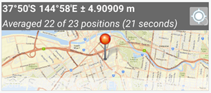
Averaging enabled on geopoint questions
Capturing a location with a single position is all well and good, but we wanted to do better. Geopoint questions now have support for averaging a series of positions into one single location.
To capture your current location, tap the location button in top right hand corner of the location panel.
To start capturing a location built from an average of positions, tap and hold the location button in top right hand corner of location panel. You will see the message appear ‘Averaged 1 of 1 positions (1 second)’.
To stop averaging, tap the location button again. To delete this location and start capturing a new one, tap the location button a third time.
If you press the form completion button whilst averaging is happening, you will cancel the current location calculation and the previous location collected will be used.
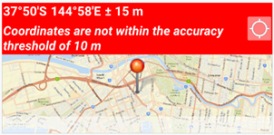
Positional accuracy threshold
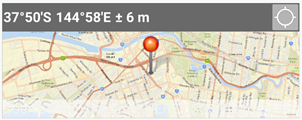
Using the new body::accuracyThreshold column title in your XLS file, you can help field users capture more accurate data. The value in this column is expressed in meters. If the device used to capture a position is reporting a positional accuracy that is less than the threshold, then the user will see the geopoint panel be shown in red and include a warning message. Once the positional accuracy is better than the threshold, the title area will go back to normal. Note that the warning does not prohibit you from capturing a location.
If averaging positions as described above, any position beyond the threshold will not be used in the location calculation.
Better Repeats
Questions inside a repeat can now contain constraints, calculations and required fields.
In the following form, multiple values and connections on a pipeline can be surveyed. The ID of each fitting is calculated to incorporate the pipe ID, and many fields are required.
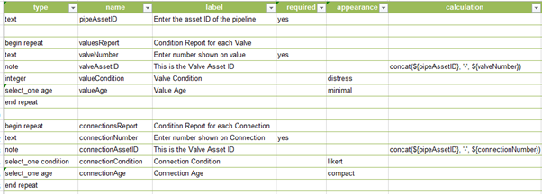
This should not be news to you, but using multiple repeats within a survey is supported as long as you do not nest them. That is, as long as you do not include a repeat, within another repeat.
Default values are not yet supported within repeats, but will come in a future release.
Other enhancements
Barcode questions now have a minimal appearance option. We will shortly publish a new blog post with more details about this.
Bugs have been fixed in the implementation of several questions. Integers will no longer overflow, while decimal fields will no longer take invalid characters. Display bugs have been fixed with time fields with single-digit minute readings, and select one questions now play nice with text scaling.
Sign-in and authentication has been improved, with Okta now supported.
The user can now rename, rotate and delete photos from the Survey123 field app.
Improvements have been made to photo browsing and selection. (iOS and Android)
Online help
Our documentation has been constantly improving, and now has a quick reference guide for the Survey123 app and website. The tutorials have also been expanded to provide more step by step details to follow, with a number of other pages also being updated with new information.
Download Survey123 Connect (1.4.30) and the field app (1.4.28) now from
http://doc.arcgis.com/en/survey123/download/
Enjoy!
You must be a registered user to add a comment. If you've already registered, sign in. Otherwise, register and sign in.