- Home
- :
- All Communities
- :
- Products
- :
- ArcGIS StoryMaps
- :
- ArcGIS StoryMaps Questions
- :
- Re: How do I turn my story map into a PDF - I'd l...
- Subscribe to RSS Feed
- Mark Topic as New
- Mark Topic as Read
- Float this Topic for Current User
- Bookmark
- Subscribe
- Mute
- Printer Friendly Page
How do I turn my story map into a PDF - I'd like to send unpublished story map to outside consultant to proof
- Mark as New
- Bookmark
- Subscribe
- Mute
- Subscribe to RSS Feed
- Permalink
I'd like to send an unpublished story map to some experts outside our organization so they can proofread it before we publish it.
I know that we could print it.
How do I make it into a PDF so I can enclose it in an email?
Solved! Go to Solution.
Accepted Solutions
- Mark as New
- Bookmark
- Subscribe
- Mute
- Subscribe to RSS Feed
- Permalink
If you are using ArcGIS StoryMaps, you can use the Print option in the header menu (the ... icon at the top) to print your draft story to a PDF.
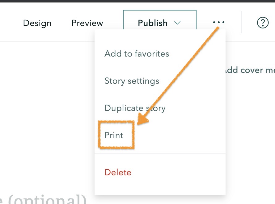
The classic journal and cascade templates can also be printed.
Lead Product Engineer | StoryMaps
- Mark as New
- Bookmark
- Subscribe
- Mute
- Subscribe to RSS Feed
- Permalink
If you are using ArcGIS StoryMaps, you can use the Print option in the header menu (the ... icon at the top) to print your draft story to a PDF.
The classic journal and cascade templates can also be printed.
Lead Product Engineer | StoryMaps
- Mark as New
- Bookmark
- Subscribe
- Mute
- Subscribe to RSS Feed
- Permalink
Hey Owen,
I know this may be a tall order and with every story map different not possible but is there a way to improve the formatting component of the print functionality? I have attached PDF's of recent story maps I have created using the print option and as you can see it isn't very appealing nor consistent.
We also need to have our story maps reviewed for accuracy and that requires hard copy versions for reviewers to use to write comments. This was obviously easier in the past when we only printed reports but we are now in our first year of doing all of our reports digitally. Our workflow has the reviewers not only review the story map itself for functionality but also the content to ensure we are producing quality data and information for the public. We are required to keep an account of all comments and suggestions and submit these to our pub shop for final approval. This year we will be giving DOI numbers to an executive summary that has a link to our story maps so this process is very important. Most reviewers prefer to use Word and use the tracking option to write comments and make edits.
So what I have been doing is sending them the PDF using the print option along with a cleaned up version in Word. What I do for the Word document is just copy and paste from the print window that opens when you select print in story maps. It does not transfer the images over but it does make the formatting a lot nicer and cleaner. I have attached the doc below so you can see what I am talking about.
My ideal method would be to submit a nice clean version with the images in it so that way our reviewers do not need to bounce back and forth between the document and story map so they can compare the figures/tables/maps to what is written in the text.
- Mark as New
- Bookmark
- Subscribe
- Mute
- Subscribe to RSS Feed
- Permalink
I completely agree with this. Even just to "print" a quick draft to proofread for corrections, errors etc a much compact printing format is needed.
Mia
- Mark as New
- Bookmark
- Subscribe
- Mute
- Subscribe to RSS Feed
- Permalink
Thanks for the feedback about printing and detailed info about your workflows, Brian and Mia. I understand your need to have a review process and "paper trail" for the story production process.
Brian -- I reviewed the exported stories you provided and see the issues you describe. Can you please let me know what type of media the poorly formatted parts are? Are they images or embeds? Are they inline pieces of media or in an immersive section (like a sidecar)?
If you could share the link to these stories so we can review them, that would be most helpful. If they are not public any information about the type and arrangement of content that produces those results would be useful for us to look into this.
Lead Product Engineer | StoryMaps
- Mark as New
- Bookmark
- Subscribe
- Mute
- Subscribe to RSS Feed
- Permalink
DRAFT Maine 2018 - Introduction
DRAFT Maine 2018 - Forest Features
DRAFT Maine 2018 - Forest Resource Attributes
DRAFT Maine 2018 - Forest Health Indicators
DRAFT Maine 2018 - Forest Ecosystem Services
DISCLAIMER: All of these story maps are in the draft phase. All figures and maps could change before final publication and should not be considered authoritative until then.
All the images have been uploaded. The two videos in the first story map were also uploaded. There are three videos in the Forest Health Indicators story map that are embedded YouTube videos.
Interactive maps are from AGOL (map viewer beta) and some of the dashboards are Esri. There are quite a few embedded (using just the links and not a custom i-Frame) Tableau dashboards in the Forest Resource Attributes story map; particularly the growth, removals, and mortality section.
Images, maps, and embeds have been placed both inline and in sidecars and from the looks I can't see a rhyme or reason why some work and some don't.
Let me know when you are done reviewing the story maps. I have temporarily made them public to assist in figuring this out so once this is done I will be taking them down until we're finished with our process.
- Mark as New
- Bookmark
- Subscribe
- Mute
- Subscribe to RSS Feed
- Permalink
@OwenGeo and our Anonymous User involved in Maine forestry,
I have found this page because I am in a similar situation that's being discussed here. We are gearing up to author and publish a State level plan that we want to publish as a StoryMap, but also need a PDF version as well. That version will possibly go through additional edits in Adobe Illustrator. We are in the early stages of this process and I need to understand the limitations and potential pitfalls before going much further.
It has been two years since this discussion took place here. Have there been any new developments? What kind of content within a StoryMap may lead to poor formatting on the PDF end that I should avoid or be prepared for? Any additional resources out there that could be helpful are welcomed. I've been exploring the training center but only watched the 2019 training seminar, "Meet the New ArcGIS StoryMaps" so far.
Thank you
- Mark as New
- Bookmark
- Subscribe
- Mute
- Subscribe to RSS Feed
- Permalink
Since this thread, we have addressed several issues that were identified in print layout (a quick search of the release notes for "print" provides a little more detail). I just took a quick look at the stories above and I don't believe I see any of the issues that were reported.
The print layout feature of ArcGIS StoryMaps is meant to provide a simple layout of the content you add to your story. It may meet your needs, but if you require something more you may need to allocate resources to also design and build a PDF version of your story.
Lead Product Engineer | StoryMaps