- Home
- :
- All Communities
- :
- Products
- :
- ArcGIS QuickCapture
- :
- ArcGIS QuickCapture Questions
- :
- Re: Quick Capture R2 iOS
- Subscribe to RSS Feed
- Mark Topic as New
- Mark Topic as Read
- Float this Topic for Current User
- Bookmark
- Subscribe
- Mute
- Printer Friendly Page
- Mark as New
- Bookmark
- Subscribe
- Mute
- Subscribe to RSS Feed
- Permalink
Does Quick Capture on iOS support the R2 with real-time corrections? I know it does not say so on the website, but maybe a future version. It does come up as an option. However, it does not want to connect to the R2 (default configured from our supplier) at all, and seems to also not play well when the GNSS is open and connected to the R2 (GNSS app loses connection).
On Android, GNSS app also loses connection when attempting to connect in Quick Capture. I can use mock BT location, with the R2 and GNSS Status up and running, and Location Provider in Quick Capture. Of course then quick capture thinks I am using the phone's GPS and does not populate the metadata correctly for the device type.
If anyone has used Quick Capture successfully with an external GPS with corrections, please let me know and give me some pointers. Which GPS device are you using? Which correction service?
Why external GPS? In my last test iOS/Quick Capture was claiming 16' accuracy, when in reality the point was 60' feet off from the corrected R2 point captured in Android. This was in non-ideal conditions, but regardless external GPS is a must for my application.
Solved! Go to Solution.
- Mark as New
- Bookmark
- Subscribe
- Mute
- Subscribe to RSS Feed
- Permalink
Johnathan Hasthorpe So I've been doing some testing with this.
It only appears to be an issue when I create a feature class in Arcgis Pro and add the GNSS meta data fields using the "Add GPS Metadata Fields" Processing Tool.
I've tested the following 3 methods which are all ok with GNSS fields being successfully populated.
- Create new Hosted Feature Layer in AGOL - Tick the "Capture GPS receiver information"
- Create New Hosted Feature Layer in AGOL - Add the GNSS metadata fields manually in the Data tab
- Create Feature Class in Arcgis Pro - Share to AGOL and manually add GNSS metadata fields
As I say, the only time there is an issue is when I use the Geoprocessing Tool in Arcgis Pro to add the metadata fields. Bizarrely if I do this and then delete the fields in AGOL and add them back in manually (like I do in 2 or 3 above) the issue persists. So I think my workaround for now is to avoid the "Add GPS Metadata Fields" tool in Pro and just add the fields manually in AGOL.
- Mark as New
- Bookmark
- Subscribe
- Mute
- Subscribe to RSS Feed
- Permalink
Hi Mark
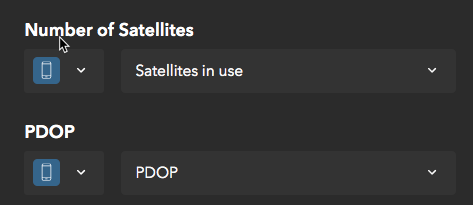
I can confirm that is an issue with the designer not automatically mapping the variables to the created fields. This happens because Pro and Online output field names with different cases (Pro uses uppercase and Online lowercase). I'll get this raised as an enhancement to fix. But for now, you will need to manually set the appropriate variable for each new field in the designer:
- Mark as New
- Bookmark
- Subscribe
- Mute
- Subscribe to RSS Feed
- Permalink
Hello all who are following this thread. I'm happy to report that Trimble R2 FW 5.51 is live and now supports iOS connection to QuickCapture!
Please use Trimble Installation Manager to update your R2 with this latest FW update. Please also read through the accompanying Support Note, and if you're interested to read further details, the Release Notes are also available.
- « Previous
-
- 1
- 2
- Next »
- « Previous
-
- 1
- 2
- Next »