Original Author: @ChristopherZent
The Esri Developer Summit 2020 in Palm Springs is almost here, scheduled March 10th – 13th. Once again, many teams have been working to provide a comprehensive line-up of offerings to help you get up to speed with the ArcGIS Pro SDK for .NET, and caught up with the latest features and patterns.
Below is a list of the many Pro SDK learning opportunities with links to all the details. There will also be many ArcGIS Pro introductory and advanced-level sessions available at Dev Summit. You can search the online agenda here.
Finally, plan to visit the ArcGIS Pro Area in the Esri Showcase to speak with Pro team members, including the SDK team. See demos of the latest features with ArcGIS Pro 2.5, ask your questions and discuss your plans for using and customizing Pro.
We look forward to seeing you at Dev Summit!
Pre-Summit Hands-On Training
Introduction to Programming with the ArcGIS Pro SDK for .NET
This two-day hands-on training workshop is a great way to get started learning and using the Pro SDK. It often fills up quickly, although depending on availability you can still register right up to the day of the training. See the link above to register.
Technical Sessions
Note: Most session titles are led by “ArcGIS Pro SDK for .NET” in the online agenda.
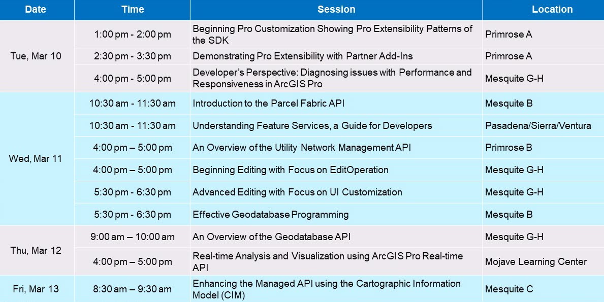
Tuesday, March 10th
Beginning Pro Customization Showing Pro Extensibility Patterns of the SDK
Learn how to customize and extend ArcGIS Pro with its .NET SDK. We’ll show you how you can get up and running quickly with the Add-in, Configuration, Plug-in, and Core Host extensibility patterns and provide an overview of “DAML” the declarative extensibility programming language for ArcGIS Pro.
Demonstrating Pro Extensibility with Partner Add-Ins
Learn about the customization opportunities available with the Pro SDK through a series of demonstrations showcasing add-in products from Esri Business Partners. With each demo, we’ll discuss the user workflow, the different Pro APIs used, and resources for developers interested in building similar capabilities.
Developer’s Perspective: Diagnosing issues with Performance and Responsiveness in ArcGIS Pro
ArcMon is a diagnostic tool contained in ArcGIS Pro. ArcMon can help determine GUI Hang, application busy state, forground and background tasks, memory usage, and more. This session will demonstrate troubleshooting performance issues within your add-ins in ArcGIS Pro. We will also go over the usage of other performance evaluators such as the performance overlay in map views, ArcGIS Pro PerfTools and other helpful utilities.
Wednesday, March 11th
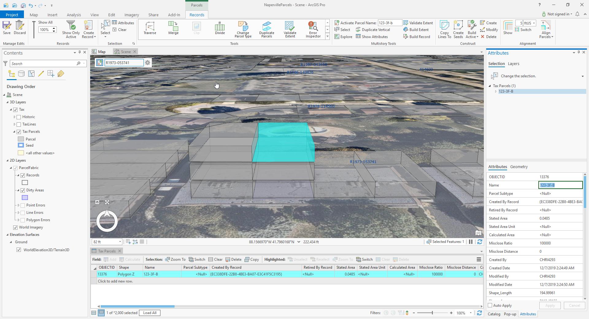
Introduction to the Parcel Fabric API
This session introduces the Parcel Fabric API which is in pre-release at 2.5. We’ll cover the information model, concepts and editing patterns. Additionally, we’ll highlight COGO-specific patterns such as using ground to grid corrections and converting between different direction formats.
Understanding Feature Services, a Guide for Developers
This is an intermediate level session for developers working with Feature Services in Pro. We will discuss feature service architecture and its relation to data storage and editing capabilities including branch versioning. We will provide guidance and insights into deployment options, authoring, publishing, caching, and dataset naming. We will explore how to work with default and named versions, short and long transaction types, and ramifications for save, undo, and cancel edits.
An Overview of the Utility Network Management API
This session will provide an overview of the utility network APIs for developing custom tools and applications for electric, gas, water and wastewater utilities. Topics to be covered will include accessing utility network metadata, tracing, and editing.
Beginning Editing with Focus on EditOperation
In this introductory session you will learn the development patterns for creating and updating features with the Editing API. We introduce the EditOperation and Inspector classes along with the different edit events. Finally you will learn how to create your own construction tool.
Advanced Editing with Focus on UI Customization
Learn how to add your own custom editing functionality into the Pro UI by creating an advanced modify tool. We show customizing the galleries and integration into the modify dockpanes. Additional topics include the EditOperation callback method, and working with mixed database environments.
Effective Geodatabase Programming
ArcGIS developers build applications that can access and interact with a geodatabase. Learn about key programming techniques and APIs that must be employed when developing high-performance geodatabase applications. This session will focus on issues that will allow developers to be more efficient, write less code, and save time. Explore the correct and effective programming patterns that should be employed when using the geodatabase API.
Thursday, March 12th
An Overview of the Geodatabase API
This session will provide an overview of the geodatabase .NET API (ArcGIS.Core.Data) for working with data in ArcGIS Pro, including working with datasets, fields, queries, selections, joins and relates.
Real-time Analysis and Visualization using ArcGIS Pro Real-time API
This session will show how to use the Real-time API to analyze, explore, and visualize events in ArcGIS Pro as they are happening in real time – whether you want to find nearby coffee shops from moving vehicles, or sending geo-fencing alerts or spatial analysis to compute affected areas as natural disaster strikes. The session also covers how to add a stream service, visualize latest and previous locations with separate renderers, limit the number of features drawn on a map based on query filter or by feature count, and draw real-time data on charts and perform analysis with them.
Friday, March 13th
Enhancing the Managed API using the Cartographic Information Model (CIM)
In this session we strip away some of the mystique surrounding the Cartographic Information Model (CIM). The Managed API exposes commonly used functionality, whereas the CIM pattern allows access to more advanced capabilities. We use examples from maps, layers, and reports but the concepts we cover are broadly applicable to all of the CIM in general.
Demo Theater Sessions
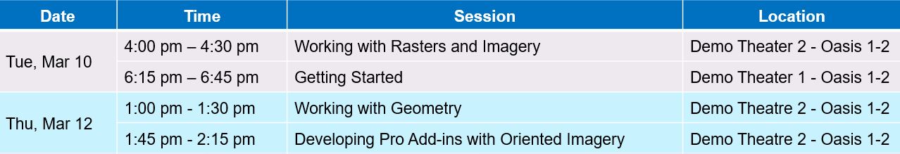
Tuesday, March 10th
Working with Rasters and Imagery
Learn how to use the ArcGIS Pro SDK with Imagery and Raster data to create compelling add-ins. Developers can use the ArcGIS Pro SDK to control how their imagery and raster data is displayed, read/write pixels and properties and control how data is processed.
Getting Started
We’ll cover beginner demos on installing the Pro SDK in Microsoft Visual Studio and building your first Pro add-ins with C#. We’ll review how to leverage the community samples as a foundation for your add-ins, and walk through the online resources.
Thursday, March 12th
Working with Geometry
From points and multipoints to segments, polylines and polygons, we will investigate and discover how to construct and manipulate geometries using the geometry builder objects. We will also introduce the GeometryEngine for performing spatial operations such as Union, Touches, Cut, Clip and more.
Developing Pro Add-ins with Oriented Imagery
Learn how the ArcGIS Oriented Imagery add-In was developed and how to develop similar capabilities in your add-ins. We’ll provide demonstrations on building code that allows users to add and work with new imagery datasets in Pro, as well as work with the built-in Chromium browser. As a developer you can incorporate oriented imagery content in Pro, and access and work with the content with add-in tools.
ArcGIS Pro Road Ahead Technical Sessions
The Road Ahead: ArcGIS Pro – Tuesday, March 10th and Thursday, March 12th
Learn about what’s new in the latest release of ArcGIS Pro and what’s coming in the next release. Members of the ArcGIS Pro development team will share an early look at new and improved capabilities in ArcGIS Pro.
ArcGIS Pro