- Home
- :
- All Communities
- :
- Products
- :
- ArcGIS Pro
- :
- ArcGIS Pro Questions
- :
- Re: viewing tin as 3D in Scene under Arcgis Pro 2....
- Subscribe to RSS Feed
- Mark Topic as New
- Mark Topic as Read
- Float this Topic for Current User
- Bookmark
- Subscribe
- Mute
- Printer Friendly Page
viewing tin as 3D in Scene under Arcgis Pro 2.0
- Mark as New
- Bookmark
- Subscribe
- Mute
- Subscribe to RSS Feed
- Permalink
- Report Inappropriate Content
i am new to ArcGIS Pro (version 2.0).
i have created a tin surface with x,y,z coordinate.
may i know how to view it in 3D? i have added / dragged to Scene, but only can view as blank
Thanks.

- Mark as New
- Bookmark
- Subscribe
- Mute
- Subscribe to RSS Feed
- Permalink
- Report Inappropriate Content
Did you try 'View Convert' ?

- Mark as New
- Bookmark
- Subscribe
- Mute
- Subscribe to RSS Feed
- Permalink
- Report Inappropriate Content
yes, but it is still blank.
and i have checked the coordinate, which shall be same as the Tin.
- Mark as New
- Bookmark
- Subscribe
- Mute
- Subscribe to RSS Feed
- Permalink
- Report Inappropriate Content
perhaps not everything is 3D or you haven't zoomed to a layer... can't test obviously, but why not start with an empty map and just the tin, once you have set all the appropriate properties so it displays first... then introduce other layers
- Mark as New
- Bookmark
- Subscribe
- Mute
- Subscribe to RSS Feed
- Permalink
- Report Inappropriate Content

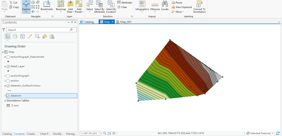
like this now after removing the coordinate, but it only appears in 2D layer?
sorry for my loads of questions, thanks
- Mark as New
- Bookmark
- Subscribe
- Mute
- Subscribe to RSS Feed
- Permalink
- Report Inappropriate Content
hello dan, i am not sure if i miss any setting in the Scene of Arcgis Pro
my friend tried to open my Tin in the ArcScene and he can view it in 3D without any setting.
my tin files for the top and second layer are uploaded to the link below
https://drive.google.com/drive/folders/1cIjcp09JCXIm6XIzLKBlUk7fEvd51YRC
may you help to see if there is any extra setting for Arcgis Pro?
Many thanks.
- Mark as New
- Bookmark
- Subscribe
- Mute
- Subscribe to RSS Feed
- Permalink
- Report Inappropriate Content
GCS_Hong_Kong_1980
This certainly isn't a geographic coordinate system. At some stage did it get defined as such? Is suspect that may be the root cause of the error
- Mark as New
- Bookmark
- Subscribe
- Mute
- Subscribe to RSS Feed
- Permalink
- Report Inappropriate Content
I couldn't get it to show in 3D .... that is when I found out it was defined as a geographic coordinate system, when in fact it was projected.
When you say 'removed' the coordinate system... how did you do it? and did you define it properly afterwards?
PS any responses from those that have viewed this post? Anything obvious we are missing?
- Mark as New
- Bookmark
- Subscribe
- Mute
- Subscribe to RSS Feed
- Permalink
- Report Inappropriate Content
actually, i just re-created the tin using default coordinates.
when i changed to hong kong coordinates, it showed nothing in the scene.
- Mark as New
- Bookmark
- Subscribe
- Mute
- Subscribe to RSS Feed
- Permalink
- Report Inappropriate Content
First check its extent in the attributes. If it's huge, like 900000 to each side, the location's wrong.
You could also check its location in 2D. Open a blank map, set CRS to 104104, load some vector data from China, then load your TIN and use TIN domain on it to get vector data. Zoom the map to extent. When you open the vector layer's attribute table you can right click and use "flash" to see where they are. Use ArcMap for this, because its "flash" option is actually useful, unlike Pro's.