- Home
- :
- All Communities
- :
- Products
- :
- ArcGIS Pro
- :
- ArcGIS Pro Questions
- :
- Pro 3.1.1 Layer to KML writing data backwards?
- Subscribe to RSS Feed
- Mark Topic as New
- Mark Topic as Read
- Float this Topic for Current User
- Bookmark
- Subscribe
- Mute
- Printer Friendly Page
Pro 3.1.1 Layer to KML writing data backwards?
- Mark as New
- Bookmark
- Subscribe
- Mute
- Subscribe to RSS Feed
- Permalink
Hi All,
I am working to develop terrain following paths for our drone (Mavic 3 Enterprise) and ran into a challenge that I am not sure how to get around - the Layer to KML gp tool is writing the coordinate points backwards (from end to start).
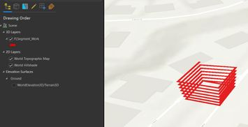
As a test, I created a simple line feature class that steps elevation from 5 to 35 meters on one leg of each revolution. If you edit the vertices of the fc there is a nice logical progression in Z value. When the layer to kml gp tool is run, the output kml has the coordinates reversed with the flight executing from the highest elevation and spiraling down to the lowest.
I can get the kml to fly (by stripping out a bunch of fluff) but when running backwards I will have to add additional points to resculpt the Z profile and avoid running into some overhanging rocks.
I have found an obvious workaround - build the path as desired then edit the line and reverse the direction so the export comes out right. But that is quite annoying.
In the attached zip is the feature class along with the kml.
Thanks in advance for any advice.
Regards,
Tom
