- Home
- :
- All Communities
- :
- Products
- :
- ArcGIS Pro
- :
- ArcGIS Pro Questions
- :
- Re: Polygon Boundaries Edges Issue
- Subscribe to RSS Feed
- Mark Topic as New
- Mark Topic as Read
- Float this Topic for Current User
- Bookmark
- Subscribe
- Mute
- Printer Friendly Page
Polygon Boundaries Edges Issue
- Mark as New
- Bookmark
- Subscribe
- Mute
- Subscribe to RSS Feed
- Permalink
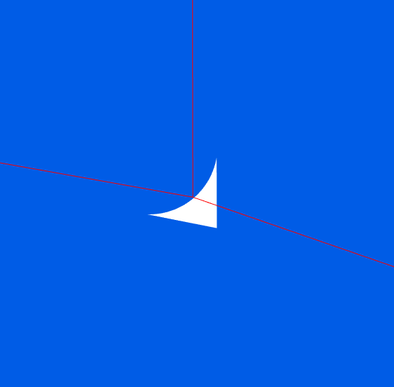
So I have a public schools boundaries feature. The boundary of one polygon has a sharp, roughly a 90 degree angle edge. The adjacent boundary has a rounded edge. This seems to be happening mostly within street intersections. I'm left with a little pyramid in between that isn't inside any boundary. Is there a good programmatic topological method to force the rounded edges to snap to the sharp edges and get rid of the gaps? There are thousands of instances of this in my data.


- Mark as New
- Bookmark
- Subscribe
- Mute
- Subscribe to RSS Feed
- Permalink
Still trying to figure this out.
- Mark as New
- Bookmark
- Subscribe
- Mute
- Subscribe to RSS Feed
- Permalink
Have you looked into using the Integrate tool? https://pro.arcgis.com/en/pro-app/tool-reference/data-management/integrate.htm
Caution:
This tool modifies the input data. See Tools that do not create output datasets for more information and strategies to avoid undesired data changes.
- Mark as New
- Bookmark
- Subscribe
- Mute
- Subscribe to RSS Feed
- Permalink
I tried using the integrate tool. It worked to close the gaps between the boundaries, but it also shifted the feature class by about a foot and a half, which is the distance of the gap between boundaries. I have the integrated copy stacked on top of the original as illustrated in the photos.
Before Integrate:

After Integrate:
- Mark as New
- Bookmark
- Subscribe
- Mute
- Subscribe to RSS Feed
- Permalink
Are these features all in the same feature class? Is there any way to split out those with the rounded corner from those with the square corner? That way, you should be able to leverage the rank to specify that the rounded corner should move to snap to the square corner.
- Mark as New
- Bookmark
- Subscribe
- Mute
- Subscribe to RSS Feed
- Permalink
Yes, it's all one feature class that we later dissolve into elementary, middle and high school boundaries. Is it normal for the integrate tool to bump features?
- Mark as New
- Bookmark
- Subscribe
- Mute
- Subscribe to RSS Feed
- Permalink
Yes, in the Usage section of that documentation I sent (https://pro.arcgis.com/en/pro-app/tool-reference/data-management/integrate.htm)
If there are any input features selected, this tool will execute only on those selected features.
This tool performs the same kind of work as a topology in that it moves features within an x,y tolerance and inserts vertices where features intersect. Consider using a topology to perform this type of operation because a topology allows you to specify rules and conditions about how features relate to each other.
It says that the tool will execute only on selected features - would there be any way for you to select just the features with rounded corners?
- Mark as New
- Bookmark
- Subscribe
- Mute
- Subscribe to RSS Feed
- Permalink
I tried only selecting the feature with the curved boundary, and it still moved the selected feature about 1.5 feet away from the coincident boundary:

- Mark as New
- Bookmark
- Subscribe
- Mute
- Subscribe to RSS Feed
- Permalink
What if you use Map Topology to make sure all the edges are properly shared? Integration has always been a 'buyer beware' sort of operation for me....
- Mark as New
- Bookmark
- Subscribe
- Mute
- Subscribe to RSS Feed
- Permalink
I don't have much experience using topology. Can I only fix one error at a time? There are thousands of instances of this in the data, which would take hundreds of hours to fix manually. I need a way to snap all of the curved edges to the 90 degree edges all at once.