- Home
- :
- All Communities
- :
- Products
- :
- ArcGIS Pro
- :
- ArcGIS Pro Questions
- :
- Make Table View Tool and Displaying Geometry Point...
- Subscribe to RSS Feed
- Mark Topic as New
- Mark Topic as Read
- Float this Topic for Current User
- Bookmark
- Subscribe
- Mute
- Printer Friendly Page
Make Table View Tool and Displaying Geometry Points
- Mark as New
- Bookmark
- Subscribe
- Mute
- Subscribe to RSS Feed
- Permalink
I need to create a table that explicitly displays the points that define a polygon boundary. Make Table View comes close, but the Shape field simply displays "Polygon". Is there a tool which outputs a list of points for each polygon?
Chuck
Solved! Go to Solution.
Accepted Solutions
- Mark as New
- Bookmark
- Subscribe
- Mute
- Subscribe to RSS Feed
- Permalink
So it was curves that was the issue. Besides that all is well. thanks for the help!!!
Chuck
- Mark as New
- Bookmark
- Subscribe
- Mute
- Subscribe to RSS Feed
- Permalink
You have to convert it a point file to get the point values
Feature Vertices To Points (Data Management)—ArcGIS Pro | Documentation
Then you can use the field calculator or
Add Geometry Attributes (Data Management)—ArcGIS Pro | Documentation or
Add XY Coordinates (Data Management)—ArcGIS Pro | Documentation
to add the coordinates to the table
... sort of retired...
- Mark as New
- Bookmark
- Subscribe
- Mute
- Subscribe to RSS Feed
- Permalink
Thanks Dan. Headed out momentarily and will try this in the AM. I suspect the geometry details (such as multiple polygons in a parcel) get lost... looking to generate something like:
Longitude | Latitude | Geometry |
-89.0259 | 38.09963 | POLYGON ((-89.0237086 38.1015136, -89.0234627 38.0976878, -89.0235319 38.097689, -89.028015 38.0977517, -89.0280308 38.0977518, -89.0283478 38.1015333, -89.0237929 38.101514, -89.0237781 38.1015139, -89.0237086 38.1015136)) |
-89.023917 | 38.120071 | MULTIPOLYGON (((-89.0231767 38.1177508, -89.0237414 38.1164201, -89.0247357 38.1164507, -89.0247523 38.1164509, -89.0248053 38.1164514, -89.0248041 38.1177957, -89.0247511 38.117794, -89.0247345 38.1177935, -89.0231767 38.1177508)), ((-89.0231767 38.1177508, -89.0231754 38.1191253, -89.0247331 38.1191616, -89.0247498 38.1191621, -89.0248028 38.1191635, -89.0248013 38.1199945, -89.0248007 38.1200951, -89.0247478 38.1200951, -89.0247315 38.1200952, -89.0247314 38.1200952, -89.0222174 38.1200228, -89.0231767 38.1177508))) |
Any Suggestions?
- Mark as New
- Bookmark
- Subscribe
- Mute
- Subscribe to RSS Feed
- Permalink
Ugly but doable

... sort of retired...
- Mark as New
- Bookmark
- Subscribe
- Mute
- Subscribe to RSS Feed
- Permalink
Interesting. I don't recognize the screen you captured... from Pro?
- Mark as New
- Bookmark
- Subscribe
- Mute
- Subscribe to RSS Feed
- Permalink
little s not S look carefully at my expression... case-sensitivity... I typed and didn't select the "Shape" from the list... learned the hard way 😉
... sort of retired...
- Mark as New
- Bookmark
- Subscribe
- Mute
- Subscribe to RSS Feed
- Permalink
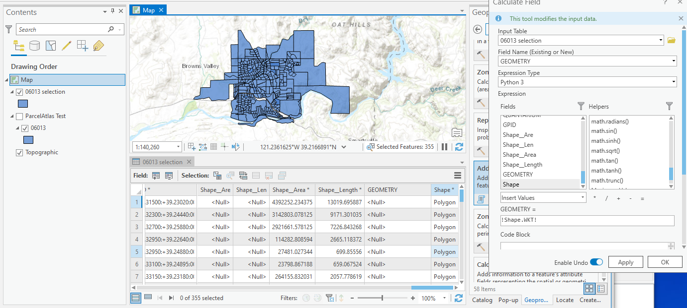
No clue why yours isn't working...
- polygon featureclass in a file geodatabase (so network-thing or web-thing)
- simple polygons, no curves or circles....
- maybe WKT doesn't handle curves well... densify the fc if you do)
- simple polygons, no curves or circles....
- Text field... WKT field name (maybe GEOMETRY isn't a good field name)
- do the field calculation watching for the small 's'
See the image.
Alternatives that I normally use... TableToNumPyArray with "explode to points", reassemble the table geometry in NumPy and export to another format
... sort of retired...
- Mark as New
- Bookmark
- Subscribe
- Mute
- Subscribe to RSS Feed
- Permalink
So it was curves that was the issue. Besides that all is well. thanks for the help!!!
Chuck