- Home
- :
- All Communities
- :
- Products
- :
- ArcGIS Pro
- :
- ArcGIS Pro Questions
- :
- Re: Logos as Labels?
- Subscribe to RSS Feed
- Mark Topic as New
- Mark Topic as Read
- Float this Topic for Current User
- Bookmark
- Subscribe
- Mute
- Printer Friendly Page
Logos as Labels?
- Mark as New
- Bookmark
- Subscribe
- Mute
- Subscribe to RSS Feed
- Permalink

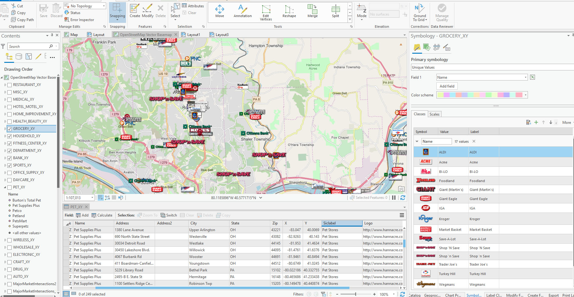
Trying to build a map for our retail team, and have been looking at a couple of options to make this more workable, which has led me to a series of questions (still too new with this software).
Based on the map above and what I'm trying to do:
1 - Can I have the logo for the retailers in a table (see Logo column in the table above) and use that as a reference for generating the symbol?
2 - Can I use the logo as a 'Label' as opposed to the symbol? Reason being, I'd like to be able to reposition the logos so they don't overlap (at differing zoom levels) and have a leader line or similar pointing to the actual retailer location?
3 - Is there a better way to do all of this that I'm completely missing?
- Mark as New
- Bookmark
- Subscribe
- Mute
- Subscribe to RSS Feed
- Permalink
Hi David,
Here’s some info on how to add logos with leader lines in ArcGIS Pro. And the answers to some questions
- When these images are converted to anno will they maintain their high resolution? - Yes
- Will that high resolution tank performance? – Images do not perform as well as you’d expect. We recommend using SVG in vector markers if at all possible.
=======================================================
To create labels using your logos follow the steps below
In ArcGIS Pro
Add logo to style:
Click View tab, Click Catalog View button
Double click Styles in Catalog View
Click Favorites
On Styles tab, Click New Item > Point Symbol
Click the newly created point symbol
On Description tab provide a name, category and tags
On Properties tab > Layers tab change from Shape marker to Picture marker
Click the File button and browse to your logo and open
Set other options like size appropriately and click Apply
Info on point symbols
http://pro.arcgis.com/en/pro-app/help/mapping/symbols-and-styles/point-symbols.htm
info on saving symbols to styles
http://pro.arcgis.com/en/pro-app/help/mapping/symbols-and-styles/save-symbols-in-styles.htm
You will need to create a separate label class for each feature that requires a different logo
Separate them out using sql queries
Info on creating label classes
http://pro.arcgis.com/en/pro-app/help/mapping/text/label-classes.htm
Add data to map, right click and select Labeling Properties to open Label Class pane
Click the Symbol tab, select the General sub tab and expand the Callout expander
Choose Point symbol from the combo box
Click the point symbol combo and select more point symbols
Browse to your added logo and click ok
Set size and leader info appropriately
Scroll up the pane and expand the Appearance expander
Under Text fill symbol set the color to No color – this prevents the label from showing and only shows the logo
Info on changing display of labels
http://pro.arcgis.com/en/pro-app/help/mapping/text/change-how-labels-are-displayed.htm
- Mark as New
- Bookmark
- Subscribe
- Mute
- Subscribe to RSS Feed
- Permalink
Is there a straightforward answer to my first question? Is there a way to use a logo that I've uploaded to a website, and included the path in the retailer table? I've created a 'Logo' column in my Pet_xy table. Would like to use the reference to call out the logo. I've got hundreds of individual logos, and creating individual styles would be time prohibitive. Thanks.
- Mark as New
- Bookmark
- Subscribe
- Mute
- Subscribe to RSS Feed
- Permalink
If you have access to Adobe Illustrator I would suggest downloading the ArcGIS extension for AI and exporting the maps to AIX and moving the logos around within illustrator because you can arrange the logos much faster that way. I would also suggest keeping a layer with as many businesses with logos as either symbols or annotations and import that symbology class to new layers so you don't have to start from scratch each time.
Overall, this is usually a very tedious and time consuming process no matter which way you try to do it.
- Mark as New
- Bookmark
- Subscribe
- Mute
- Subscribe to RSS Feed
- Permalink
David, I am trying to do a very similar activity--did you ever find a way to put logos (many) to XY points?