- Home
- :
- All Communities
- :
- Products
- :
- ArcGIS Pro
- :
- ArcGIS Pro Questions
- :
- Issues with Geocoding
- Subscribe to RSS Feed
- Mark Topic as New
- Mark Topic as Read
- Float this Topic for Current User
- Bookmark
- Subscribe
- Mute
- Printer Friendly Page
- Mark as New
- Bookmark
- Subscribe
- Mute
- Subscribe to RSS Feed
- Permalink
Hello,
I am having problems with geocoding a table I have to create for myself by looking up each individual address on the internet. This is for my research project in my undergraduate program.
These are the following errors I am receiving:
000622 : Failed to execute (<value>). Parameters are not valid
000732 : <value>: Dataset <value> does not exist or is not supported.
(In Attachements (HELP))
I tried working on this problem in ArcGIS Pro but it gave me an online subscription error, so I moved to ArcMap 10.5.1 and these are the errors I received (as mentioned above).
These are the steps I followed:
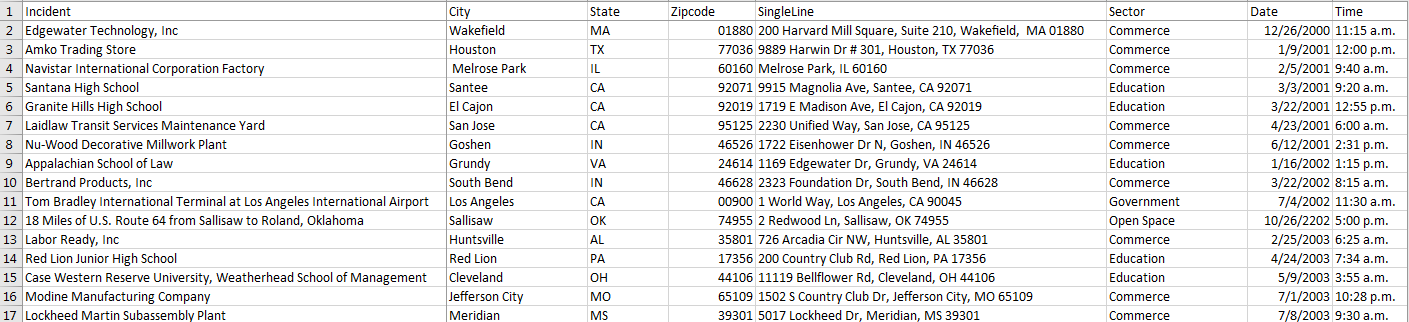
1) Converted my excel file to a csv (comma delimited) file (converted back to an xls file but received the same errors)
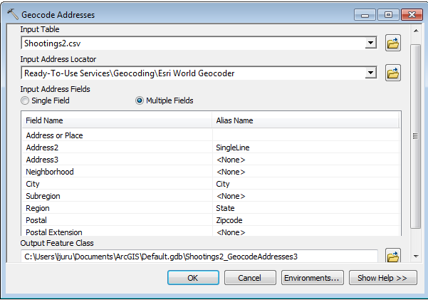
2) Opened up the Geocoding tool (see attachments (Attempt1 and Attempt2)
I would greatly appreciate any advice on how to resolve this issue. It would help me finally move forward in my project and actually begin to analyze the data.
Thank you in advance,
Lisa
Solved! Go to Solution.
Accepted Solutions
- Mark as New
- Bookmark
- Subscribe
- Mute
- Subscribe to RSS Feed
- Permalink
Lisa:
Based on your screen shots:
- The format of your table looks good, but you may need to add an underscore _ to the end of the Date and Time fields to avoid any conflicts with reserved words.
- You are using the Esri World Geocoder to batch geocode the table, but in order to use the service you need to be signed into ArcMap with your ArcGIS Online organization user name and password and your ArcGIS Online organization account must have geocoding permissions.If you have a public ArcGIS Online account you will only be able to geosearch (locate an address one at a time) with the Esri World Geocoder in ArcMap or ArcGIS Pro. Working with the ArcGIS Online World Geocoding Service—Help | ArcGIS Desktop
- Attempt1 is correct as long as you are signed into ArcGIS Online with an organization account with geocoding permissions to use the Esri World Geocoder. Using the Singleline field is the best option based on the info in your table.
- Attempt2 has incorrect field mapping for Multiple Fields because the Singleline field already contains the address, city, state, and zip code components of the address, so there is no need to select the other individual city, state, zip code fields. If you mapped 'Incidents' field to "Address or Place", dropped Singleline from Address2 and kept city, state, zipcode fields you would match most of the records that are not names of businesses.
You may want to check if your school has an ArcGIS Online organization that you are a part of or have access to or if they provide other online services that you can use or possibly StreetMap Premium locators.
-Shana
- Mark as New
- Bookmark
- Subscribe
- Mute
- Subscribe to RSS Feed
- Permalink
Lisa
This will be a mostly anecdotal response, And maybe you have sorted this out by now.
What I have observed:
- Old (previous version) locators - are not recognized in catalog or in geocoding process (FAILS)
- used co-workers 10.3.1 and built new ArcMap locators that did function and I could use in 10.5.1
- ArcPRO - also doesn't recognize ArcMap locators (build in ArcPro geoprocessing tools checks good. Also the above is also true about locators - probably need to rebuilt.
- Re-matching a data-set that had previously been geocoded, but AFTER I attempted update one locator in a Composite - mistake on my part given above comments....trouble reading table.arcgis 10.5#
Good luck...Nate
- Mark as New
- Bookmark
- Subscribe
- Mute
- Subscribe to RSS Feed
- Permalink
Lisa:
Based on your screen shots:
- The format of your table looks good, but you may need to add an underscore _ to the end of the Date and Time fields to avoid any conflicts with reserved words.
- You are using the Esri World Geocoder to batch geocode the table, but in order to use the service you need to be signed into ArcMap with your ArcGIS Online organization user name and password and your ArcGIS Online organization account must have geocoding permissions.If you have a public ArcGIS Online account you will only be able to geosearch (locate an address one at a time) with the Esri World Geocoder in ArcMap or ArcGIS Pro. Working with the ArcGIS Online World Geocoding Service—Help | ArcGIS Desktop
- Attempt1 is correct as long as you are signed into ArcGIS Online with an organization account with geocoding permissions to use the Esri World Geocoder. Using the Singleline field is the best option based on the info in your table.
- Attempt2 has incorrect field mapping for Multiple Fields because the Singleline field already contains the address, city, state, and zip code components of the address, so there is no need to select the other individual city, state, zip code fields. If you mapped 'Incidents' field to "Address or Place", dropped Singleline from Address2 and kept city, state, zipcode fields you would match most of the records that are not names of businesses.
You may want to check if your school has an ArcGIS Online organization that you are a part of or have access to or if they provide other online services that you can use or possibly StreetMap Premium locators.
-Shana