- Home
- :
- All Communities
- :
- Products
- :
- ArcGIS Pro
- :
- ArcGIS Pro Questions
- :
- How to “clear” the coordinate system of the “Map” ...
- Subscribe to RSS Feed
- Mark Topic as New
- Mark Topic as Read
- Float this Topic for Current User
- Bookmark
- Subscribe
- Mute
- Printer Friendly Page
How to “clear” the coordinate system of the “Map” to get it to “unknown” in ArcGIS Pro,
- Mark as New
- Bookmark
- Subscribe
- Mute
- Subscribe to RSS Feed
- Permalink
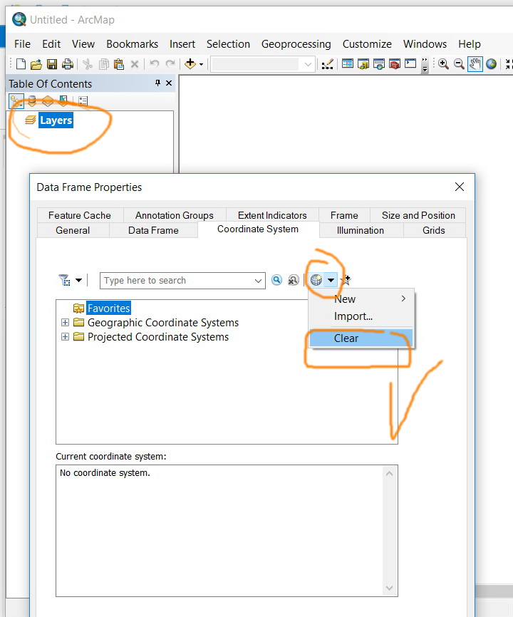
How to “clear” the coordinate system of the “Map” to get it to “unknown” in ArcGIS Pro,
For example, in ArcMap, the clear option is available and one can set the “data frame” to unknown. I couldn’t figure out how to “clear” the coordinate system of the “Map” to get it to “unknown” in ArcGIS Pro as this option is not there
Jamal Numan
Geomolg Geoportal for Spatial Information
Ramallah, West Bank, Palestine
- Mark as New
- Bookmark
- Subscribe
- Mute
- Subscribe to RSS Feed
- Permalink
Jamal, thank you for starting this discussion.
Dan, I appreciate your comments on this post, as i have the same questions as Jamal. I use the 'clear projection' as a stop gap measure to prevent 'projecting on the fly' in ArcMap, almost identically to how Jamal uses it.
My concern is how ArcPro knows which projection to use for the layer. If the projection (or coordinate system) is defined incorrectly, how would ArcPro know? Where would it 'put' the data in space?
It sounds as though it would project on the fly, to the incorrect coordinate system?
Agreed that determining the actual coordinate system ahead of using the data is the best approach. I do so, and direct my students to do so, however, this 'clearing of the projection on the fly' is a good stop gap measure to ensure that the data is lining up.
Thoughts?
- Mark as New
- Bookmark
- Subscribe
- Mute
- Subscribe to RSS Feed
- Permalink
Gregory... When I am using someone else's data, I actually follow the advice given in the previous threads.
I don't like to rely on stop gaps or anything else.
In fact, I still think projection on the fly was a bad idea when it was introduced.
At least in old-school arcview 2/3.x, when you data "didn't line-up" you knew that you were dealing with unknown or incorrectly defined coordinate systems.
People waste more time trying to figure out why subsequent processes don't work properly than they would by getting the data into the necessary and the same coordinate system to begin with. Storage is cheap. I keep my data in geographic and projected coordinates and I use the form appropriate for the task
- Mark as New
- Bookmark
- Subscribe
- Mute
- Subscribe to RSS Feed
- Permalink
Dan,
I'm in full agreement on checking and double checking, but... when teaching students, i have found that this little 'stop gap' is a great way to show it to them, explain about the data being in different spaces.
If they click 'full extent' and their data doesn't line up, they know that they forgot to do something.
Similar with 'Clear Projection'... If one of the layers disappears.... they realize right away that there is an issue.
This gives them a visual, and concrete reasoning of why we must line up our data, rather than it being an abstract concept. Thus far... 10 years in, it has worked, students 'get it' and rarely make Coordinate System/Projection mistakes after the 'Coordinate System and Projections' lab!
- Mark as New
- Bookmark
- Subscribe
- Mute
- Subscribe to RSS Feed
- Permalink
True Gregory... as long as they remember to zoom to full extent 
- Mark as New
- Bookmark
- Subscribe
- Mute
- Subscribe to RSS Feed
- Permalink
I’m sure, Dan, why are even against to having it an optional!. We do really need it at our work and can’t live without it.
I would appreciate if other experts can share us the discussion on this
Jamal Numan
Geomolg Geoportal for Spatial Information
Ramallah, West Bank, Palestine
- Mark as New
- Bookmark
- Subscribe
- Mute
- Subscribe to RSS Feed
- Permalink
I know this is two years after the fact, however, I do not think that Jamal (& Jamal please correct me if I'm wrong) wishes to utilize an 'Unknown' Coordinate system, rather... he (and I) would like to utilize the actual coordinate systems of the data/layers.
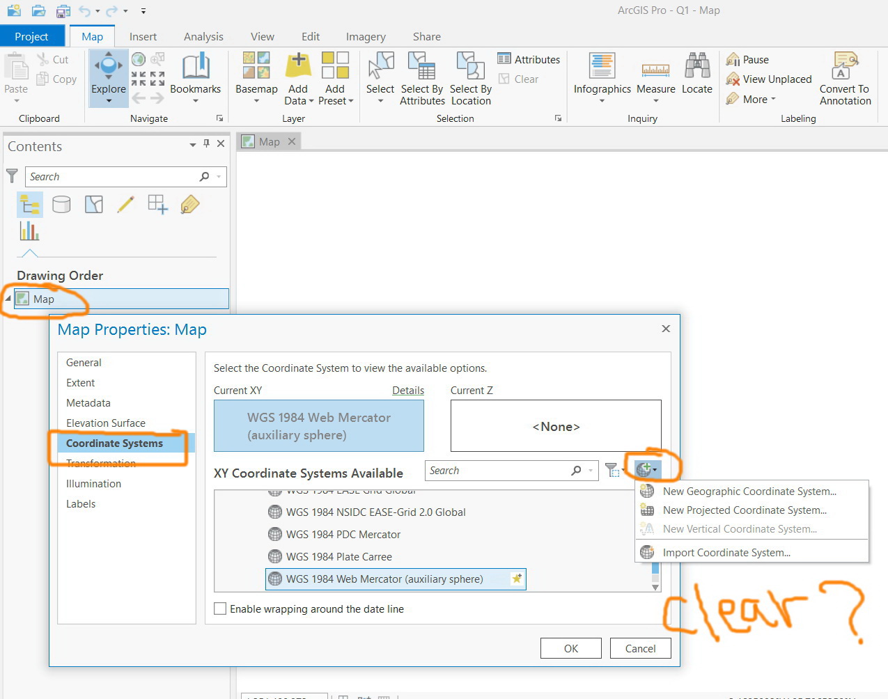
To me, what Pro is doing, essentially... is Projecting on the Fly, no?, rather than utilizing the actual coordinate system of the layers/data?
To Repeat my question from 15 October 2019:
I'm writing to ask... what does ArcPro do then? Project on the fly? Project in the Layer's coordinate system? I haven't been able to find the answer to this.
Regards.
- Mark as New
- Bookmark
- Subscribe
- Mute
- Subscribe to RSS Feed
- Permalink
Gregory - here's the AGP workflow for project on the fly behavior.
- When a new map is added to an AGP project, the default coordinate system for the Map View is WGS 1984 Web Mercator Auxiliary Sphere.
- The first vector/raster dataset added to the new Map View defines the coordinate system for the Map View. (i.e. UTM Zone 13N NAD83 for example)
- All vector/raster datasets that are not in the now default coordinate system for the new Map View (i.e. UTM) are projected on the fly to match the coordinate system of the Map View. (ex. uncoming GDB FC is in Stateplane NAD 83 Colorado Central "projects on the fly" to UTM Zone 13N NAD83) The coordinate system for the incoming datasets are not changed.
- Any geographic transformation warning error messages are automatically resolved by AGP. In ArcMap, it would throw a warning message for the user to fix. Many people clicked Close not knowing what this meant.
Hope this helps!
- Mark as New
- Bookmark
- Subscribe
- Mute
- Subscribe to RSS Feed
- Permalink
Thank you guys for the rich input
I need to re-confirm that we do still need the “clear” option in ArcPro. This option used to be in ArcMap since ages. It is a simple as this. I’m not sure why this should be very challenging for developers to have it implemented in the Pro
Jamal Numan
Geomolg Geoportal for Spatial Information
Ramallah, West Bank, Palestine
- Mark as New
- Bookmark
- Subscribe
- Mute
- Subscribe to RSS Feed
- Permalink
I'm writing to ask... what does ArcPro do then? Project on the fly? Project in the Layer's coordinate system? I haven't been able to find the answer to this.
Ironic... I just uploaded a video about Coordinate Systems and Projections for my introduction to GIS course at the University of Washington Tacoma.
- Mark as New
- Bookmark
- Subscribe
- Mute
- Subscribe to RSS Feed
- Permalink
So in researching this question a bit further, there is a bug number (BUG-000114029) for it although technically it's not a bug. As described to the customer "Unfortunately removing the ability to set 'none' coordinate system in Pro is a design decision. Having no coordinate system could lead to lots of problems..." The support call also references this thread as well. Lastly there is an ArcGIS Idea submitted for this item that is marked as Reviewed.