- Home
- :
- All Communities
- :
- Products
- :
- ArcGIS Pro
- :
- ArcGIS Pro Questions
- :
- Re: How do I correct distance measurements/calcula...
- Subscribe to RSS Feed
- Mark Topic as New
- Mark Topic as Read
- Float this Topic for Current User
- Bookmark
- Subscribe
- Mute
- Printer Friendly Page
How do I correct distance measurements/calculations for handmade polygons?
- Mark as New
- Bookmark
- Subscribe
- Mute
- Subscribe to RSS Feed
- Permalink
- Report Inappropriate Content
Hello all.
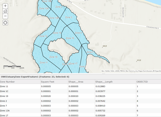
Although this clip of my map is displayed on ArcGIS Online, I created it in ArcGIS Pro.
I drew this polygon of an estuary by tracing the shoreline from an aerial image. Then I separated the polygon into different zones (polygons) where volunteers will collect and track an invasive plant called frogbit.
For the analysis, I need to know how many square feet each of the zones are, but as you can see from my table, that information is not correct. Based on the scalebar the estuary zones should be more than 600 feet across in some areas, but the table shows shape feet, area and length in minuscule numbers which are less than a foot. Does anyone know how I can fix this to show true distances using ArcGIS Pro?
I appreciate any help you can offer!
Robin
- Mark as New
- Bookmark
- Subscribe
- Mute
- Subscribe to RSS Feed
- Permalink
- Report Inappropriate Content
I think this is due to the units of the spatial reference of the data. If the units are degrees, then it won't look like what you're expecting. Right-clicking a column in ArcGIS Pro (you can add the feature service to Pro), you will see an option to "Calculate Geometry". This also lets you choose which projection/spatial reference (and thererefore, units) you want the resulting calculation to be done in. If you pick a local projection that has the units you would prefer, you can ensure to get something useful. There is also a way using Arcade that will allow you to do a field calculation to get the result in your desired units.
- Mark as New
- Bookmark
- Subscribe
- Mute
- Subscribe to RSS Feed
- Permalink
- Report Inappropriate Content
Thank you, Doug. I will also try your methods and see what I come up with.
- Mark as New
- Bookmark
- Subscribe
- Mute
- Subscribe to RSS Feed
- Permalink
- Report Inappropriate Content
Those default Shape fields are calculated automatically by the database backing the data using the spatial reference of the feature class. In most cases they're completely useless and should be ignored. There's a few ways to get the proper area for a feature:
- Good ol' Calculate Geometry Attributes. This gives you the most flexibility in how you do the math and the output units, but you'll have to run the tool every time a feature updates which won't work for every workflow.
- Use the Area or AreaGeodetic Arcade functions in a popup or attribute rule. The former does the calculation every time a user picks a feature in a web map in the popup only, the latter does the calculation on every insert/update and stores the result in a field. This gives you real-time updates on the Area, the catch is "Area" doesn't let you specify the spatial reference so you'll have to test what reference it uses for the calculations. If that isn't good enough then you'll have to use AreaGeodetic, which is fine for most purposes but you may be required to calculate geometry in a specific SR which means you'll have to fall back to option 1.
Give these options a try, you should find something that suits your workflow and requirements.
- Mark as New
- Bookmark
- Subscribe
- Mute
- Subscribe to RSS Feed
- Permalink
- Report Inappropriate Content
Thank you David!
I will give those a try.
