- Home
- :
- All Communities
- :
- Products
- :
- ArcGIS Pro
- :
- ArcGIS Pro Questions
- :
- How do get geopackage layers to display in ArcPro ...
- Subscribe to RSS Feed
- Mark Topic as New
- Mark Topic as Read
- Float this Topic for Current User
- Bookmark
- Subscribe
- Mute
- Printer Friendly Page
How do get geopackage layers to display in ArcPro 2.3.0?
- Mark as New
- Bookmark
- Subscribe
- Mute
- Subscribe to RSS Feed
- Permalink
- Report Inappropriate Content
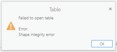
I am trying to load layers from a geopackage into ArcGIS Pro v2.3 to perform some geoprocessing. When I add the layers to the map they appear in the table of contents, but do not display on the map canvas. When I try and open the attribute table I get an error, "Shape integrity error" (error image below). I fixed the geometry of the layers and tried again. This still resulted in the same error. When I tried to open the data in ArcMap 10.5.1 everything worked fine - the layers loaded, rendered, and the attribute table was viewable. Accessing the data also worked perfectly in QGIS 3.4. Is there a way to get geopackage data to display in ArcPro? I can geoprocess in other environments but for publishing services to AGOL I would prefer to have the ability to use ArcPro to publish data stored in a geopackage due to the more flexible and complex symbology options available in ArcPro versus ArcMap.
- Mark as New
- Bookmark
- Subscribe
- Mute
- Subscribe to RSS Feed
- Permalink
- Report Inappropriate Content
In AGP, there is a Create SQLite Database GP tool with a parameter to create a GeoPackage database (1.0, 1.1, 1.2). I wonder if it's a "version" issue?
- Mark as New
- Bookmark
- Subscribe
- Mute
- Subscribe to RSS Feed
- Permalink
- Report Inappropriate Content
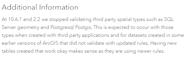
See the explanation here: https://support.esri.com/en/bugs/nimbus/QlVHLTAwMDExOTQwNg==
I'm wondering if you'd be able to create a new geopackage in 2.3 and move the features into that... so that if the writing happens in the current version, it would work???
- Mark as New
- Bookmark
- Subscribe
- Mute
- Subscribe to RSS Feed
- Permalink
- Report Inappropriate Content
Also, as for the ultimate goal of publishing the geopackage, it doesn't look like that is currently supported: 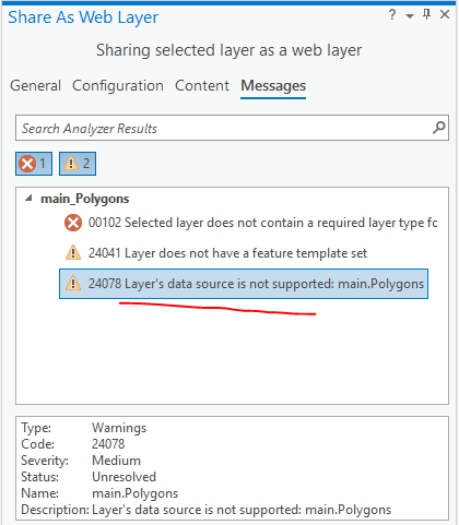
I'd recommend posting that as an idea on ArcGIS Ideas in the Desktop category. Would be handy to have.
- Mark as New
- Bookmark
- Subscribe
- Mute
- Subscribe to RSS Feed
- Permalink
- Report Inappropriate Content
Just a note in passing, Geopackages are supported as static items in ArcGIS Online, so you can directly share them this way, and given valid geometry you can apply symbology from a layer file (for example).
- Mark as New
- Bookmark
- Subscribe
- Mute
- Subscribe to RSS Feed
- Permalink
- Report Inappropriate Content
I get the same error trying to read a geopackage file created by another person in QGIS 3x. ArcMap 10.6.1 will give me a longer more detailed error message, and then show me the table but not the polygons. QGIS can use it fine, and convert it to a shapefile that ArcGIS can read.