- Home
- :
- All Communities
- :
- Products
- :
- ArcGIS Pro
- :
- ArcGIS Pro Questions
- :
- Re: Hide or delete color on tif?
- Subscribe to RSS Feed
- Mark Topic as New
- Mark Topic as Read
- Float this Topic for Current User
- Bookmark
- Subscribe
- Mute
- Printer Friendly Page
- Mark as New
- Bookmark
- Subscribe
- Mute
- Subscribe to RSS Feed
- Permalink
Hi: In fire incident mapping, the convention is to eliminate most colors on a digital map, especially the vegetation classes, leaving mostly place names and brown contour lines. In Arc 10, this was pretty easy with a Tiff because you'd just click on the color map in the TOC, click on the colors you wanted to eliminate (usually green for veg) then change to 'no color.'
I haven't figured out how to do that in Pro nor have I figured out how to identify the specific code associated with the corresponding color (the identify tool has disappeared and the Explore tool doesn't seem to do it for a raster).
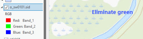
Also, some of my maps are sid and only show RGB. Is there a way of doing the same in those? Or, after figuring out above, is it just easier to convert to tiff then change?
Thanks!
George
Solved! Go to Solution.
Accepted Solutions
- Mark as New
- Bookmark
- Subscribe
- Mute
- Subscribe to RSS Feed
- Permalink
In Pro, my Explore tool is definitely identifying the ColorMap.PixelValue ok. In the Explore drop down have you got it set to Visible Layers?
The solution to changing individual colours to NoData\Transparent appears to be in this post at the bottom: https://community.esri.com/t5/education-questions/how-do-i-change-color-on-colormap-using-arcpro/m-p...
- Mark as New
- Bookmark
- Subscribe
- Mute
- Subscribe to RSS Feed
- Permalink
I can't remember what that old page said, but this seems to work. Select your layer in the TOC, then in the Symbology drop down choose Unique Values. It should keep the same colors.

Then in the Symbology panel you should be able to click on individual colors and change them to No Color.

- Mark as New
- Bookmark
- Subscribe
- Mute
- Subscribe to RSS Feed
- Permalink
In Pro, my Explore tool is definitely identifying the ColorMap.PixelValue ok. In the Explore drop down have you got it set to Visible Layers?
The solution to changing individual colours to NoData\Transparent appears to be in this post at the bottom: https://community.esri.com/t5/education-questions/how-do-i-change-color-on-colormap-using-arcpro/m-p...
- Mark as New
- Bookmark
- Subscribe
- Mute
- Subscribe to RSS Feed
- Permalink
Yay. That's it. Solved both identify and the link solved the color problem. Many thanks!
George
- Mark as New
- Bookmark
- Subscribe
- Mute
- Subscribe to RSS Feed
- Permalink
George
can you explain how you solved? the link doc is not available any more....
- Mark as New
- Bookmark
- Subscribe
- Mute
- Subscribe to RSS Feed
- Permalink
Arrrgh! I could have sworn I put that in my notes (teaching a class...). But it's not there and, with memory like a sieve, I forgot how except that, once I saw it, it was pretty easy. That doesn't help you at all, does it? I'll keep looking in my notes. But maybe @Tim_McGinnes remembers??
I also remember I asked some fire mapping people and they didn't know either, which was kinda worrisome... .
- Mark as New
- Bookmark
- Subscribe
- Mute
- Subscribe to RSS Feed
- Permalink
I need a solution to this as well, as the link is gone. We use USGS topographic maps as our base-maps and there is no way to easily make it so the white background is set to no color. Is there any way to edit internal colormaps in Pro, it says to click to modify symbol but yet doesn't allow me to? It was really easy to do in ArcMap just right click the color you wanted to change and change the color, in Pro it doesn't let me change the colors in symbology. A workaround I've found is to the open the topographic map in ArcMap then set the white background value to 'No color' then save that as a layer file, then in Pro 'Import from layer file' to get the correct symbology. It works, but it is an inconvenience, especially since every topographic map has a different value for the white background so for every quadrangle you would have to go through this process. Below is an example of importing a layer file to a different quadrangle than the original layer file was created from... Any tips?

- Mark as New
- Bookmark
- Subscribe
- Mute
- Subscribe to RSS Feed
- Permalink
I can't remember what that old page said, but this seems to work. Select your layer in the TOC, then in the Symbology drop down choose Unique Values. It should keep the same colors.
Then in the Symbology panel you should be able to click on individual colors and change them to No Color.
- Mark as New
- Bookmark
- Subscribe
- Mute
- Subscribe to RSS Feed
- Permalink
Yes, I think that was it. Thanks! I know I did it after it was answered here but, heh, forgot because I didn't need it. I'll copy and paste this one into my ongoing 'notes of stuff I'll probably forget'.... . Thanks again!