- Home
- :
- All Communities
- :
- Products
- :
- ArcGIS Pro
- :
- ArcGIS Pro Questions
- :
- Extract Values to Table: wrong number of pixels
- Subscribe to RSS Feed
- Mark Topic as New
- Mark Topic as Read
- Float this Topic for Current User
- Bookmark
- Subscribe
- Mute
- Printer Friendly Page
Extract Values to Table: wrong number of pixels
- Mark as New
- Bookmark
- Subscribe
- Mute
- Subscribe to RSS Feed
- Permalink
Hello
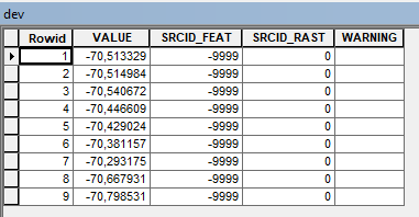
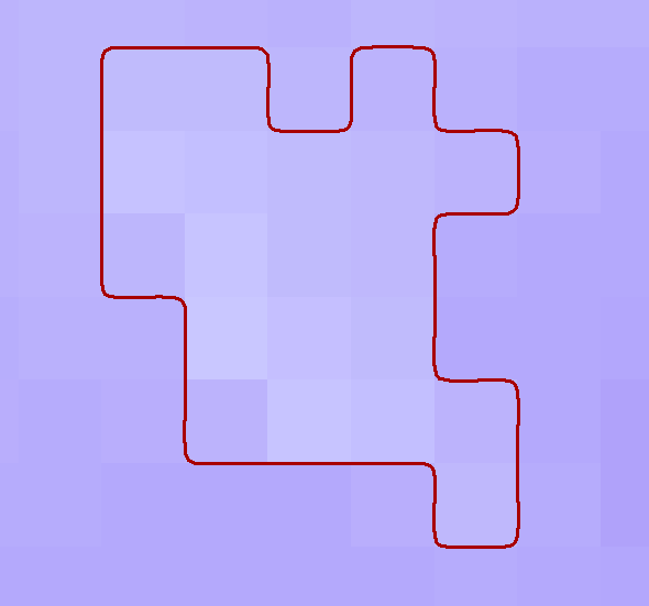
I am iterating through a shapefile using a SearchCursor to extract the pixel values of a raster for each polygon in the shapefile using the Extract Values to Table (Geostatistical Analyst) tool. However, I noticed something strange - the number of pixel extracted for each polygon does not correspond to the right number of pixel encompassed by the polygon. I have attached a figure as example - the polygon contains 20 pixels (figure 1), however only 9 are extracted by the tool (figure 2). This is a snippet of the code I am using:
with arcpy.da.SearchCursor(in_features,['SHAPE@', 'FID']) as cursor:
for row in cursor:
try:
print('processing row '+str(row[1]))
arcpy.ga.ExtractValuesToTable(row[0], input_raster, workspace + 'dev')
Any idea of what is going on?