- Home
- :
- All Communities
- :
- Products
- :
- ArcGIS Pro
- :
- ArcGIS Pro Questions
- :
- Clip tool giving strange output outside scope of f...
- Subscribe to RSS Feed
- Mark Topic as New
- Mark Topic as Read
- Float this Topic for Current User
- Bookmark
- Subscribe
- Mute
- Printer Friendly Page
Clip tool giving strange output outside scope of features to clip
- Mark as New
- Bookmark
- Subscribe
- Mute
- Subscribe to RSS Feed
- Permalink
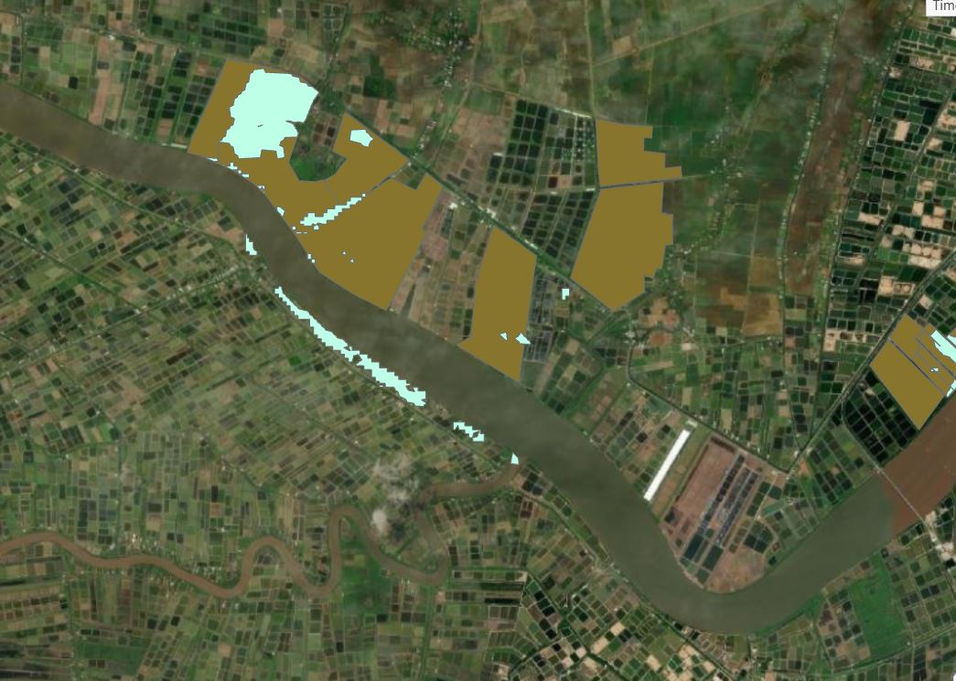
I have a layer with Shapefiles (see image shofiles), and a layer with mangrove coverage (see image mangrove deforested). I only want to keep the mangrove coverage where it is within the boundaries of one of the shapefiles, so I used Clip to clip the shapefiles from the mangrove layer. This works like intended, except that some parts are not correctly clipped, there is mangrove coverage within shapefiles that is not kept, and there is data kept that falls outside the shapefile boundaries (see image clipped mangrove).
Can somebody tell me what is going wrong?
Solved! Go to Solution.
Accepted Solutions
- Mark as New
- Bookmark
- Subscribe
- Mute
- Subscribe to RSS Feed
- Permalink
Project to a local projection [PCS] > add the projected layers to a new map > perform the clip.
Ensure that in the Clip environments the output coordinates are the same projection as the inputs layers.
- Mark as New
- Bookmark
- Subscribe
- Mute
- Subscribe to RSS Feed
- Permalink
That's strange. Can you take a screenshot of your clip settings? Are they in the same projection/CRS?
- Mark as New
- Bookmark
- Subscribe
- Mute
- Subscribe to RSS Feed
- Permalink

Thanks David. I have set the extent to multiple settings to see if that would make a difference, but it came out the same for each try.
- Mark as New
- Bookmark
- Subscribe
- Mute
- Subscribe to RSS Feed
- Permalink
what about the CRS for the input features and clip features?
- Mark as New
- Bookmark
- Subscribe
- Mute
- Subscribe to RSS Feed
- Permalink
Both are in GCS_WGS_1984
- Mark as New
- Bookmark
- Subscribe
- Mute
- Subscribe to RSS Feed
- Permalink
Laura - do you shapefiles have a *.prj file for both of them? If they're in different projected coordinate systems, have you set the Geographic Transformation? I would also try exporting the shapefiles to file geodatabase feature classes and redo the workflow. What is the result?
- Mark as New
- Bookmark
- Subscribe
- Mute
- Subscribe to RSS Feed
- Permalink
They both have the .prj file. I have reprojected one of the layers to GCS_WGS_1984, so they are the same. When I tried exporting them to geodatabase features, the clip tool only generated empty output, while the extent was set to default
- Mark as New
- Bookmark
- Subscribe
- Mute
- Subscribe to RSS Feed
- Permalink
Hmmmm...interesting. Are you able to share the data with us in this thread so I can work with it in my ArcGIS Pro for testing purposes. If not attached in the thread, my email is rleclair at esri dot com Thx!
- Mark as New
- Bookmark
- Subscribe
- Mute
- Subscribe to RSS Feed
- Permalink
Project to a local projection [PCS] > add the projected layers to a new map > perform the clip.
Ensure that in the Clip environments the output coordinates are the same projection as the inputs layers.
- Mark as New
- Bookmark
- Subscribe
- Mute
- Subscribe to RSS Feed
- Permalink
This worked perfectly, thanks!