- Home
- :
- All Communities
- :
- Products
- :
- ArcGIS Pro
- :
- ArcGIS Pro Questions
- :
- Re: Background of the map missing when exporting
- Subscribe to RSS Feed
- Mark Topic as New
- Mark Topic as Read
- Float this Topic for Current User
- Bookmark
- Subscribe
- Mute
- Printer Friendly Page
- Mark as New
- Bookmark
- Subscribe
- Mute
- Subscribe to RSS Feed
- Permalink
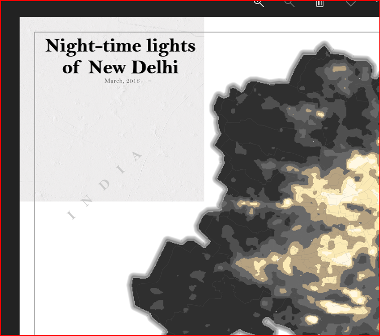
Hi, I am trying to export a map but the background is missing. By background I mean then basemap I used in my map. No matter the options I use (i.e. export as tif, or png, or whatever, 200/300/600 etc DPI, the compression etc) I still get a portion of the basemap. The basemap is the topobathy and a hillshade from the living atlas. See the image attached for what the problem is. Many thanks
Solved! Go to Solution.
Accepted Solutions
- Mark as New
- Bookmark
- Subscribe
- Mute
- Subscribe to RSS Feed
- Permalink
Thank you all for you suggestions. I managed to solve the issue by exporting as .aix and then process the output using Adobe Illustrator.
- Mark as New
- Bookmark
- Subscribe
- Mute
- Subscribe to RSS Feed
- Permalink
They suggest some fixes here, but sounds like you've tried most of those
https://support.esri.com/en/technical-article/000023776
Have you tried printing to pdf instead of exporting?
- Mark as New
- Bookmark
- Subscribe
- Mute
- Subscribe to RSS Feed
- Permalink
Actually, exporting as pdf is the only solution that works. i forgot to mention this. But the problem with exporting it as pdf is that I want to import the map into a LO writer document (ms word). Also, I selected A4 paper as my 'canvas'.
- Mark as New
- Bookmark
- Subscribe
- Mute
- Subscribe to RSS Feed
- Permalink
Is it possible you have TIFF images in your map? Many folks have had an issue with say a company logo or other image that is a tiff file. https://community.esri.com/t5/arcgis-pro-questions/export-layout-to-pdf-that-includes-tif-logo-fails...
- Mark as New
- Bookmark
- Subscribe
- Mute
- Subscribe to RSS Feed
- Permalink
I do have a tif image yes, the university's logo. Let me to export the map without the tif image and I'll post the result here in a little while
- Mark as New
- Bookmark
- Subscribe
- Mute
- Subscribe to RSS Feed
- Permalink
No, same result. I am guessing I'll have to stick with the pdf export and then figure out how to import the image (without losing the quality) in a LO writer document

- Mark as New
- Bookmark
- Subscribe
- Mute
- Subscribe to RSS Feed
- Permalink
I apologize for reiterating, but Printing to a PDF format will create a pdf file.

- Mark as New
- Bookmark
- Subscribe
- Mute
- Subscribe to RSS Feed
- Permalink
Yes I know that it will create a pdf file, I just wanted to point out that it was the only way to print my map without losing any information.
- Mark as New
- Bookmark
- Subscribe
- Mute
- Subscribe to RSS Feed
- Permalink
Hi nik_geo,
I believe you are running into a known limitation: see BUG-000124449 Living Atlas tiled layers consumed through a portal do not completely export to .jpg in a large format with high DPI at small scales in ArcGIS Pro 2.4
The missing tiles are occurring because exporting this service at the repro resolution exceeds the size/request limit of this service. I would recommend to use the cached tiled service (World Hillshade - https://www.arcgis.com/home/item.html?id=1b243539f4514b6ba35e7d995890db1d), which is meant to be used as basemap and such export map use cases.
Hope this helps.
Tom
- Mark as New
- Bookmark
- Subscribe
- Mute
- Subscribe to RSS Feed
- Permalink
Thank you all for you suggestions. I managed to solve the issue by exporting as .aix and then process the output using Adobe Illustrator.