- Home
- :
- All Communities
- :
- Products
- :
- ArcGIS Pro
- :
- ArcGIS Pro Questions
- :
- Re: ArcGIS Pro Create Locator fails
- Subscribe to RSS Feed
- Mark Topic as New
- Mark Topic as Read
- Float this Topic for Current User
- Bookmark
- Subscribe
- Mute
- Printer Friendly Page
- Mark as New
- Bookmark
- Subscribe
- Mute
- Subscribe to RSS Feed
- Permalink
Pro 2.4
The Create Locator tool with a Point Address role, bails out on a feature class of roughly 500K address points:
Messages
Start Time: Thursday, July 11, 2019 9:58:35 AM
Start building locator...
Start transforming data...
Start processing Point Address role
Error happened while transforming data
Failed to execute (CreateLocator).
Failed at Thursday, July 11, 2019 9:58:55 AM (Elapsed Time: 19.91 seconds)
Not much to work with with respect to error messages. This data resides in in and enterprise gdb, and it bailed out using the egdb as a source, so I saved it to a fgdb and bailed out there as well. Anyone else using this new approach to creating a locator?
edited to add: the create address locator tool in 2.4 works just fine...
Solved! Go to Solution.
Accepted Solutions
- Mark as New
- Bookmark
- Subscribe
- Mute
- Subscribe to RSS Feed
- Permalink
Hi Joe,
Just to follow up and close the loop in this thread, I took a look at your data with the analyst assigned to your Support case, and the issue is related to null geometry in your data. Running Check Geometry on the data shows two records with null geometry:
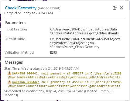
Running Repair Geometry on the feature class and then attempting to run the Create Locator tool again was successful.
-Eric
- Mark as New
- Bookmark
- Subscribe
- Mute
- Subscribe to RSS Feed
- Permalink
Joe:
What is the projection of the point features?
Does the point feature class support m-values?
Can you provide a screen shot of the field mapping?
- Mark as New
- Bookmark
- Subscribe
- Mute
- Subscribe to RSS Feed
- Permalink
Shana- State Plane Utah Central Nad 83 feet. No m values. I'll add a screen shot once i get into the office. I started "whitling down" the feature class by selecting the first 10k, first 100k, first 200k,... first 500k records. It's somewhere in the last 2500 object ids that makes it fail. Seems like a data issue, and I need to figure out what the problem is so I can mitigate for it. Weird though that the create address locator tool doesn't have a problem with the data.
Shana Britt edited to add the parameters from a successful run:
Parameters
Country or Region USA
Primary Table(s) AP455274_455313 PointAddress
Field Mapping 'PointAddress.HOUSE_NUMBER AP455274_455313.ADDR_HN';
'PointAddress.STREET_PREFIX_DIR AP455274_455313.ADDR_PD';
'PointAddress.STREET_NAME AP455274_455313.ADDR_SN';
'PointAddress.STREET_SUFFIX_TYPE AP455274_455313.ADDR_ST';
'PointAddress.STREET_SUFFIX_DIR AP455274_455313.ADDR_SD';
'PointAddress.SUB_ADDRESS_UNIT AP455274_455313.UNIT_DESIG'
This particular run was on a small subset of our address points; oids 455274-455313.
- Mark as New
- Bookmark
- Subscribe
- Mute
- Subscribe to RSS Feed
- Permalink
It is weird that the Create Address Locator tool does not have an issue with the point feature class. Is the geometry type in the Shape column 'Point' or 'Multipoint'? You will likely need to submit a support ticket to send the data along for further investigation if you are not able to figure out what's wrong with those 2500 features.
- Mark as New
- Bookmark
- Subscribe
- Mute
- Subscribe to RSS Feed
- Permalink
Just simple points; not multi points.
Yes, I may submit a ticket for it. In our ever changing world, my back burner projects move forward and vice-versa. I'll turn things down to a simmer in a day or so, and get back after geocoding.
- Mark as New
- Bookmark
- Subscribe
- Mute
- Subscribe to RSS Feed
- Permalink
Just took a look at the on-line help (wow, what a thought!) introducing roles and in the matrix it shows:
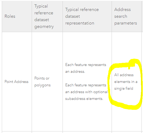
The help continues with 'it must have individual fields that contain a street number and street name information', which contradicts the matrix, and the concept that the locator parses out the elements Further down in the help doc is:

Which looks very much like our data. The Create Locator tool supports the idea of address elements being parsed out in individual fields, so you should see my confusion here....
- Mark as New
- Bookmark
- Subscribe
- Mute
- Subscribe to RSS Feed
- Permalink
Joe:
The part of the matrix you circled is related to searching the address, which needs to be in a single field for batch geocoding. The reference data needs to have the address components broken up into multiple fields as illustrated in the table image in the Subaddress section of the PointAddress role. The roles matrix is no different from the styles matrix https://desktopdev.arcgis.com/en/arcmap/latest/manage-data/geocoding/commonly-used-address-locator-s....
- Mark as New
- Bookmark
- Subscribe
- Mute
- Subscribe to RSS Feed
- Permalink
Oh. Okay, I got it now. Duh.
So people actually parse out the address table? That's never been a consideration for me....
- Mark as New
- Bookmark
- Subscribe
- Mute
- Subscribe to RSS Feed
- Permalink
Joe, Yes, I've seen people parse out the input address table they want to geocode so many times over the years.
- Mark as New
- Bookmark
- Subscribe
- Mute
- Subscribe to RSS Feed
- Permalink
Joe:
Did you ever get the address locator to work as I am getting the same error message?
Are you sourcing your data from SDE, a file gdb on a network share, file gdb on a local drive or somewhere else?