- Home
- :
- All Communities
- :
- Products
- :
- ArcGIS Pro
- :
- ArcGIS Pro Questions
- :
- Re: Amazon cloud storage connection doesn't displa...
- Subscribe to RSS Feed
- Mark Topic as New
- Mark Topic as Read
- Float this Topic for Current User
- Bookmark
- Subscribe
- Mute
- Printer Friendly Page
Amazon cloud storage connection doesn't display shp and fgdb in Pro catalog
- Mark as New
- Bookmark
- Subscribe
- Mute
- Subscribe to RSS Feed
- Permalink
ArcGIS Pro 2.3
Added cloud storage connection to AWS, I can now see our bucket contents in the Catalog explorer when I expand the (.acs) connection.
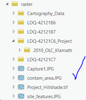
However, only rasters (tif/jpg etc) display as items I can add to the project.
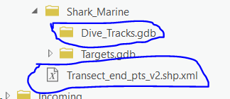
Shapefiles do not show, only their associated .shp.xml files. File Geodatabases do not display either, they show as folders which, when expanded, are empty.
I have verified that the shapes and fgdb's are live, not corrupt - they can be read in Desktop 10.4.1
What gives?


Solved! Go to Solution.
Accepted Solutions
- Mark as New
- Bookmark
- Subscribe
- Mute
- Subscribe to RSS Feed
- Permalink
Only rasters are currently supported.
What’s New in Imagery and Remote Sensing (ArcGIS Pro 2.3)
ArcGIS Cloud Storage Connection files
ArcGIS is powered by a scalable and optimal information model for managing large volumes of imagery: the mosaic dataset. ArcGIS Pro 2.3 now enables you to make direct connections to cloud stores and to work with imagery natively as image layers in your project.
The new ArcGIS Cloud Store connection (ACS) file allows you connect to cloud stores directly, browse buckets/folders and access imagery in your project. AWS, Azure, and Alibaba are the currently supported cloud stores.
Create Cloud Storage Connection File—Help | ArcGIS Desktop
Summary
Creates a connection file for ArcGIS-supported cloud storage. It allows existing raster geoprocessing tools to write cloud raster format (CRF) datasets into the cloud storage bucket or read raster datasets (not limited to CRF) stored in the cloud storage as input.
- Mark as New
- Bookmark
- Subscribe
- Mute
- Subscribe to RSS Feed
- Permalink
I am having the same problem, any resolution to this?
- Mark as New
- Bookmark
- Subscribe
- Mute
- Subscribe to RSS Feed
- Permalink
Only rasters are currently supported.
What’s New in Imagery and Remote Sensing (ArcGIS Pro 2.3)
ArcGIS Cloud Storage Connection files
ArcGIS is powered by a scalable and optimal information model for managing large volumes of imagery: the mosaic dataset. ArcGIS Pro 2.3 now enables you to make direct connections to cloud stores and to work with imagery natively as image layers in your project.
The new ArcGIS Cloud Store connection (ACS) file allows you connect to cloud stores directly, browse buckets/folders and access imagery in your project. AWS, Azure, and Alibaba are the currently supported cloud stores.
Create Cloud Storage Connection File—Help | ArcGIS Desktop
Summary
Creates a connection file for ArcGIS-supported cloud storage. It allows existing raster geoprocessing tools to write cloud raster format (CRF) datasets into the cloud storage bucket or read raster datasets (not limited to CRF) stored in the cloud storage as input.
- Mark as New
- Bookmark
- Subscribe
- Mute
- Subscribe to RSS Feed
- Permalink
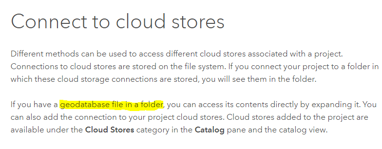
I was looking at this documentation, maybe next release.

https://pro.arcgis.com/en/pro-app/help/projects/connect-to-cloud-stores.htm
- Mark as New
- Bookmark
- Subscribe
- Mute
- Subscribe to RSS Feed
- Permalink
I see what you mean, but the wording of that sentence is odd to me. Is it just a typo and they meant to say "file geodatabase" instead of "geodatabase file?" If the latter, what is a geodatabase file?
Fundamentally, Esri really needs to clearly document "ArcGIS-supported cloud storage." My idea of clearly documenting is having single page that lists them, not scattering them throughout the documentation.
- Mark as New
- Bookmark
- Subscribe
- Mute
- Subscribe to RSS Feed
- Permalink
I submitted the following documentation bug: [BUG-000121415: The 'Connect to cloud stores' documentation must be re-worded to clarify that the functionality is specific to raster data and does not support connection to other file types in the cloud.] Thank you for pointing out the confusion on this topic.
- Mark as New
- Bookmark
- Subscribe
- Mute
- Subscribe to RSS Feed
- Permalink
I just stumbled across this Cloud Storage Connection today, so thanks for the clarification Kory.
Sooooooo, is it on the roadmap for this feature to support all of ESRI's file based datasources? That could be a game-changer for many organizations I would think...
Warren
- Mark as New
- Bookmark
- Subscribe
- Mute
- Subscribe to RSS Feed
- Permalink
Thanks for the feedback, Andrew. We'll take a look at the help to try to clear up confusion.
- Mark as New
- Bookmark
- Subscribe
- Mute
- Subscribe to RSS Feed
- Permalink
The link Andrew provides above is exactly what i was going off of. "geodatabase file" sounds a lot like a generic term for "any file that can be stored in a geodatabase". Product documentation clarity FTW.
- Mark as New
- Bookmark
- Subscribe
- Mute
- Subscribe to RSS Feed
- Permalink
Kory Kramer - Thank You.