- Home
- :
- All Communities
- :
- Products
- :
- ArcGIS Pro
- :
- ArcGIS Pro Questions
- :
- Re: Aggregate and Block statistics returning highe...
- Subscribe to RSS Feed
- Mark Topic as New
- Mark Topic as Read
- Float this Topic for Current User
- Bookmark
- Subscribe
- Mute
- Printer Friendly Page
Aggregate and Block statistics returning higher values than before.
- Mark as New
- Bookmark
- Subscribe
- Mute
- Subscribe to RSS Feed
- Permalink
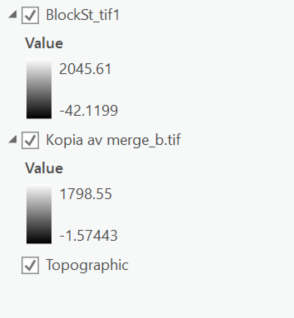
Hey Everyone. Everytime I run aggregate or block statistics to reduce the resolution of a DEM I end up with higher maximum and minimum values then before. Does anyone know any reason why I'm running into that? The picture shows what I'm talking about. Thanks
- Mark as New
- Bookmark
- Subscribe
- Mute
- Subscribe to RSS Feed
- Permalink
what are the input raster statistics?
what were the options you used for aggregate and block statistics?
(cell size, block size etc)
- Mark as New
- Bookmark
- Subscribe
- Mute
- Subscribe to RSS Feed
- Permalink
It's a 23 GB DEM with a cell size of 0.000277, tiff, floating point, the resolution is 30 meters.
For aggregate I used mean with a cell factor of 2, I want to get to 60 meters to work better with the image without losing too much. I also market not to expand extent if needed.
For block statistics, I dont really know how to use it. I just choose "rectangle" width and height "3" and unit type "cell".
My goal with it all is to use the basin function, but since the original DEM is too bit it would take ages to do it.
Thanks for the help.