- Home
- :
- All Communities
- :
- Products
- :
- ArcGIS Pro
- :
- ArcGIS Pro Ideas
- :
- Cluster Rendering for ArcMap
- Subscribe to RSS Feed
- Mark as New
- Mark as Read
- Bookmark
- Follow this Idea
- Printer Friendly Page
- Mark as New
- Bookmark
- Subscribe
- Mute
- Subscribe to RSS Feed
- Permalink
Cluster rendering was demonstrated at the Esri UC Plenary and looks like a great capability. Would like to see this renderer added to the desktop products.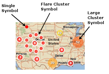
- « Previous
-
- 1
- 2
- 3
- Next »
We are currently working supporting clustering in ArcGIS Pro. It is too early to put a release number on that. But hoping to bring this capability to our user community by the end of this year or the next.
We'd really appreciate if you could share your use case.
As I mentioned in my previous comment, please take a look at Feature Binning capability and see if that helps you in the meantime.
@TanuHoque thanks, we are aware of feature bining. We re not looking for alternatives, we need this at some time.
@TanuHoque Well it's nothing more than the obvious usercase: we d'like to display quite large and partly densly populated point Datasets (heteregenous). This ist partly possible with heatmaps for some far out zoomscales but when zooming in, a quantitative view is required, hence the count of certain points aggregated by category. Otherwise the map is completely overcharged and unreadable. Hexagon bins is not really the ideal replacement, but could be the best for now in our case. Disperse of symbols/labels ist not an option as is does not solve the overcrowded issue, it's just an offset. Plus further geoprocessing in between input and map is not really wished before displaying the points as this becomes quiet complicated. The whole thing has to work with Pro 2.7 and ArcGIS Enterprise Portal 10.7, so technological compatibility between server side, data and GIS desktop is key.
Thanks @Geo_Supp
I hope you won't mind for two follow up questions.
a quantitative view is required, hence the count of certain points aggregated by category....
Are you suggesting that points should be cluster not just based on their spatial proximity but also by categories? Let's say there are 4 points very close to each other and they should be clustered to a single cluster-point based on a given cluster-radius. Now, say two of them belongs to CategoryA and the other two to CategoryB. Do you want two cluster points (one for each category) instead of one cluster point?
The whole thing has to work with Pro 2.7 and ArcGIS Enterprise Portal 10.7
Do you want to share that as a map image layer aka map service and want to change cluster related properties of the map image layer using web clients? or you want to share out and consume that as a feature layer on your web apps?
I really appreciate all your feedback. This helps us tremendously.
@TanuHoque really it is hard to answer on the dry without being able to try. Basically any clustering would be an advantage for a start. Then yes clustering with category discrimination would be nice, so optionaly chosing a unique value discrimination field so that for a location it shows that on this point/radius there is 5 Cat A Points and 7 Cat B. But I guess this could also be achieved by duplicating layers and changing the query, as far as cluster results layers do not overlap with each other.
About the format of the sharing, unsure what the advantage and cons of each would be. I guess both could be fine, whatever is more performant or easy. In our case the Input points would probably be in a csv or other table and previously be pre-processed(or not) in FME. Loading/displaying the csv (changing daily) directly in Portal would certainly be a nice shortcut too, the productive workflow ist not finished in this case.
This is implemented in ArcGIS Pro 2.9. See Ideas in ArcGIS Pro 2.9 or go directly to 6:44 in the video.
Thanks for the update @KoryKramer, this is a good improvement, will test the implications
(just updated to 2.9.2)
Tested it, actually not very well implemented:
- not intuitiv, unclear parameters
- impossible to cluster in defined groups without overlapping, for ex it does cluster multiple categories together, no way to cluster per unique value, is there?
- when clustering there are still the single features i a group, quiet difficult to understand how these two groups conflict with eachother. Scales settings are also very unintuitiv.
You must be a registered user to add a comment. If you've already registered, sign in. Otherwise, register and sign in.