- Home
- :
- All Communities
- :
- Products
- :
- ArcGIS Pro
- :
- ArcGIS Pro Ideas
- :
- ArcGIS PRO Cursor Identify tolerance
- Subscribe to RSS Feed
- Mark as New
- Mark as Read
- Bookmark
- Follow this Idea
- Printer Friendly Page
ArcGIS PRO Cursor Identify tolerance
- Mark as New
- Bookmark
- Subscribe
- Mute
- Subscribe to RSS Feed
- Permalink
When selecting points you must be exactly on top of feature to identify. The point tolerance is not adjustable for identify. The snapping tolerances are adjustable but not the identify feature from the Explore tool. Please make the Explore tool tolerance adjustable.
This is reported at version 2.3.2
- « Previous
-
- 1
- 2
- Next »
You could hold Ctrl + and drag a box with the Explore tool :
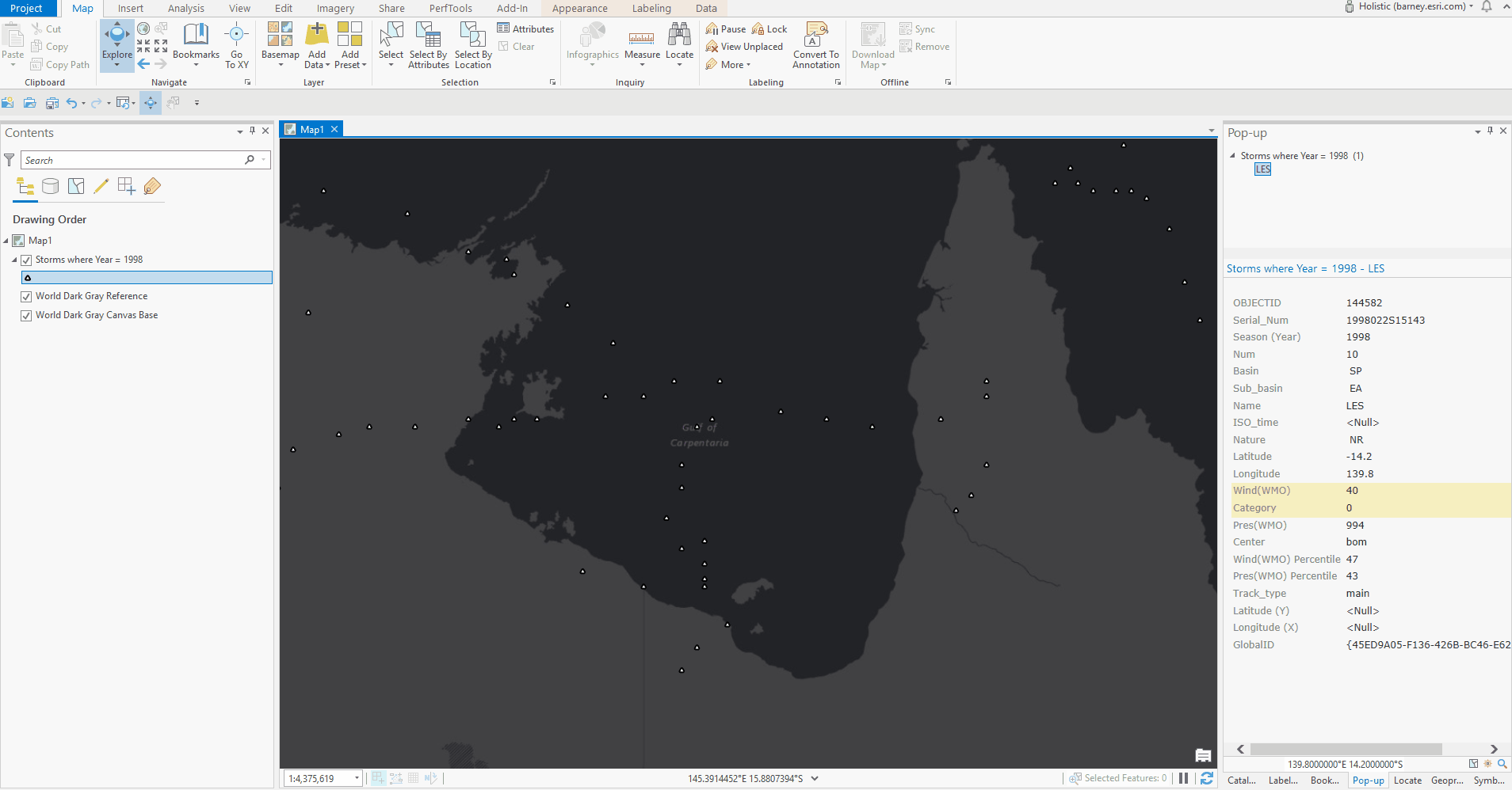
Kory Kramer I vaguely recall showing this to you during a screen share during our ID tool discussion(s). The issue here is in ArcMap, there is some sort of "snapping" going on when clicking the ID tool "near" a point. The Pro identify tool is a regression in functionality and useability:
- Now requires two hands to execute
- Introduces more wrist movement(s)
- Introduces more time needed to execute
- Not exactly smooth on laptops with nothing but a touchpad, tablets, or touch screens.
- The drag-the-box method requires more precision when points are tightly clustered
So let's put the dragging boxes aside:
As the OP points out, getting the mouse cursor EXACTLY on the point also
- Introduces more wrist movement(s)
- Introduces more time needed to execute
- Not exactly smooth on laptops with nothing but a touchpad, tablets, or touch screen
Hey Tom. My suggestion to drag a box was just to provide a way to do it today. At the time that the idea was reviewed, I tagged it with arcmap equivalency as was pointed out by the OP and you.
This is also a major issue in WAB and AGOL.
Is there any time frame when Esri will add click tolerance options to Pro, WAB, and AGOL?
This seems like a pretty basic option to have. ArcMap desktop had it for decades with Selection > Selection Options > Selection tolerance: __ pixels.
The problem with identify in pro is that all the feature of ArcMap are missing. In ArcMap it's easy to make interrogation with many layers of data. You could choose the top, selected, visible, all layer.
I'm stick to use ArcMap in project because mostly but not exclusively due to that identify not as easy to use.
Hi Marcel,
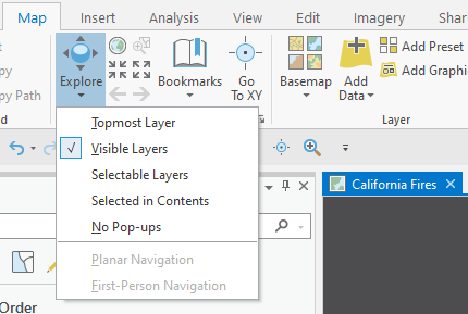
In Pro you can set the Explore tool to act on Topmost, Visible, Selectable, Selected in Contents, or have no Pop-ups at all.
Is that what you were referring to when comparing to ArcMap's Identify tool?
Yes, I lost it. For me exploration was to move around. Hard to follow everything since name changes.
Just try it, work fine but, take forever (minutes) to querying a small area with 14 layers. Stick with ArcMap to do identify for now until the speed problem could be resolved.
The first try was with default setting (topmost) but give me all layers, like visible layers, not only the top one (rubber band box for the querry). Try with a layer not visible and then, the uncheck layer was not there's fine there.
By the way, could we change the default topmost for visible. Always awkward to stick with the top layer since its use is very, very limited. We need to know what's on the map, not by default the top even if with the bug, that’s fine for me.
I would love to see this setting as well! As a third-party developer, we have a custom selection tool that does a spatial query based on the clicked point. If a user's search tolerance isn't high enough, they have to be nearly pixel-perfect to select a feature, depending on their scale. The only workaround we've found is to programmatically increase the search tolerance and re-run the spatial query up to a pre-determined maximum value. For example, we may start with the default of 3, then keep increasing by 5 until we've tried 4 more queries; if nothing is found after that, we consider nothing to be selected and the user must try again.
Count me in! Please make the Explore tool tolerance adjustable!!
Sure, using the Ctrl key does work, but it is not nearly as friendly and fluid as having a larger tolerance available for Identify.
You must be a registered user to add a comment. If you've already registered, sign in. Otherwise, register and sign in.