- Home
- :
- All Communities
- :
- Products
- :
- ArcGIS Online
- :
- ArcGIS Online Questions
- :
- Re: Unable to import this shapefile (timeout excee...
- Subscribe to RSS Feed
- Mark Topic as New
- Mark Topic as Read
- Float this Topic for Current User
- Bookmark
- Subscribe
- Mute
- Printer Friendly Page
Unable to import this shapefile (timeout exceeded)
- Mark as New
- Bookmark
- Subscribe
- Mute
- Subscribe to RSS Feed
- Permalink
Hello!
I've been trying for quite some time now to import a shapefile and every time it says that it cannot be imported due to an exceeded timeout. I've been able to import files that were larger than this one with no issue. Attached is the zipped file I'm attempting (and failing) to import. Please help me preserve some of my sanity.
Solved! Go to Solution.
Accepted Solutions
- Mark as New
- Bookmark
- Subscribe
- Mute
- Subscribe to RSS Feed
- Permalink
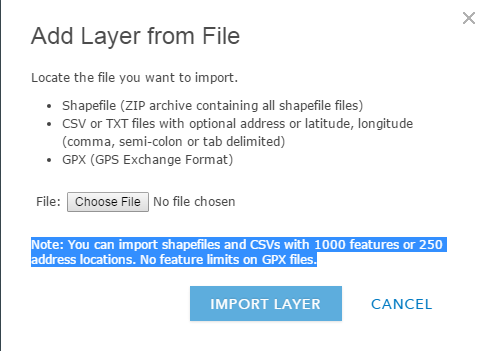
If your shapefile has more than 1000 features it won't work. Your shapefile contains 3771 features.
- Mark as New
- Bookmark
- Subscribe
- Mute
- Subscribe to RSS Feed
- Permalink
Please note that the 1000 feature limit is specific to adding a storing shapefile data directly in the web map. If you add the shapefile via My content and choose to publish it as a feature layer, there is no limit to the features. The article Shantonu Sarkar shared goes into more details about the specific limitation that FC Basson is pointing to.
Erin Woolbright, if you are running into timeout issues there may be poor network connectivity or if your file is over 10MB in size, you may be running into a browser limitation. If you use ArcGIS Pro or ArcMap, try publishing the layer as a feature service and this will be successful. ArcGIS Pro and ArcMap upload the item in parts to overcome the size limitations that exist in web browsers.
Shapefiles—ArcGIS Online Help | ArcGIS
Thanks,
Kelly
- Mark as New
- Bookmark
- Subscribe
- Mute
- Subscribe to RSS Feed
- Permalink
Erin,
If you are trying to import the shapefile, please refer FAQ: Is there a feature limit in ArcGIS Online?
Hope this help.
~Shan
~Shan
- Mark as New
- Bookmark
- Subscribe
- Mute
- Subscribe to RSS Feed
- Permalink
FC Basson thanks a thousand for the speedy reply. I eventually used a different dataset that overall took me longer to modify and fix data paths in order to import than it would've to select the features that I needed from the posted .shp. Shantonu Sarkar, thank you for the article reference, that helped. Kelly Gerrow, the connection that I use it not the best. I am painfully green when it comes to AGOL. I do use ArcMap and thank you very much for the workaround info!
Cheers,
Erin