- Home
- :
- All Communities
- :
- Products
- :
- ArcGIS Online
- :
- ArcGIS Online Questions
- :
- Re: summarize center and dispersion - what is cent...
- Subscribe to RSS Feed
- Mark Topic as New
- Mark Topic as Read
- Float this Topic for Current User
- Bookmark
- Subscribe
- Mute
- Printer Friendly Page
summarize center and dispersion - what is centerX centerY?
- Mark as New
- Bookmark
- Subscribe
- Mute
- Subscribe to RSS Feed
- Permalink
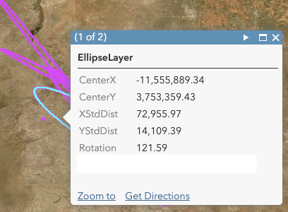
When I run the ArcGIS Online analysis tool "Summarize Center and Dispersion" it creates an ellipse layer that looks pretty good... but instead of having latitude and longitude, it has fields "centerX" and "centerY" ... which are numbers that don't make sense. I'm not sure what the units are, and exactly what they mean?
See the screenshot for example:
Solved! Go to Solution.
Accepted Solutions
- Mark as New
- Bookmark
- Subscribe
- Mute
- Subscribe to RSS Feed
- Permalink
I dont know if this is of any help, good luck!
https://community.esri.com/thread/222695-latlong-unit-conversion-with-arcade
- Mark as New
- Bookmark
- Subscribe
- Mute
- Subscribe to RSS Feed
- Permalink
They are probably the center coordinates in a Web Mercator projection which is probably the projection of the map
- Mark as New
- Bookmark
- Subscribe
- Mute
- Subscribe to RSS Feed
- Permalink
This is my suspicion - but - and I'm a little naive on this - the X being -11,555,889.34 ... I'm not sure how to convert that to a usable coordinate... for example. That number seems too big. 11.5 million meters?
- Mark as New
- Bookmark
- Subscribe
- Mute
- Subscribe to RSS Feed
- Permalink
Its somewhere by the new mexico/Texas border by that coordinate in WM.
- Mark as New
- Bookmark
- Subscribe
- Mute
- Subscribe to RSS Feed
- Permalink
That's right. My issue is that I need to be able to dynamically pull a coordinate pair out of the feature that I can feed into Ops Dashboard. I'm not clear how to convert -11.5 million for centerX into decimal degrees.
- Mark as New
- Bookmark
- Subscribe
- Mute
- Subscribe to RSS Feed
- Permalink
I dont know if this is of any help, good luck!
https://community.esri.com/thread/222695-latlong-unit-conversion-with-arcade
- Mark as New
- Bookmark
- Subscribe
- Mute
- Subscribe to RSS Feed
- Permalink
I tried the math and it looks like it will work but something about the math is a little off... Latitude should be around -110, and the math in the link was making it come out around -71.... odd. Need to look more. But this is definitely what I was looking for.