- Home
- :
- All Communities
- :
- Products
- :
- ArcGIS Online
- :
- ArcGIS Online Questions
- :
- Re: living atlas layers in public maps made with W...
- Subscribe to RSS Feed
- Mark Topic as New
- Mark Topic as Read
- Float this Topic for Current User
- Bookmark
- Subscribe
- Mute
- Printer Friendly Page
living atlas layers in public maps made with Web AppBuilder
- Mark as New
- Bookmark
- Subscribe
- Mute
- Subscribe to RSS Feed
- Permalink
I would like to be able to make public maps that show living atlas layers. Is there currently any way to do this? Requiring a user login to access a map that utilizes these layers seems counter intuitive to the whole "maps for all" message.
We are trying to show floodplains on a map that we are making public but no one but those of us with logins can see the data.
So in order for anyone else to see this I have to 1) created a guest user with an internal email 2) login for the first time and reset the just created password (why ESRI why?) 3) put myself, that user, and the user creating the map into a group so we can access the maps and keep them separate 4) pass along user name and password (and keep track of) various "guest" logins.
It would be easier if there were a private, non-user based password protected view or a link accessible but private view.
Or if we could just see living atlas layers in public map.
Any thoughts? Am I making the miscellaneous guest user process to difficult? We have about 5-10 of them already taking up some of our 50 seats.
Solved! Go to Solution.
Accepted Solutions
- Mark as New
- Bookmark
- Subscribe
- Mute
- Subscribe to RSS Feed
- Permalink
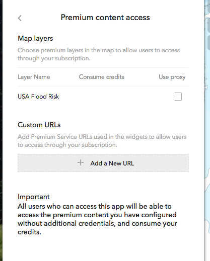
You can setup access to this content in the Web App Builder. To do so go to the "Attribute" section then click on 'Premium Content Access". This will bring up a form that allows you to create proxy for premium or subscriber content in the map or specify a custom url to proxy.
- Mark as New
- Bookmark
- Subscribe
- Mute
- Subscribe to RSS Feed
- Permalink
Hi Jennifer,
The following blog outlines how to use subscriber content in web apps and story maps, which is the issue that you have described above:
Using subscriber content in Web Apps and Story Maps | ArcGIS Blog
OEvans-esristaff does a great job explaining the difference between subscriber content and premium content and how to set up your app so that it can be accessed by the public without requiring a login.
Please let us know if you have any questions,
Kelly
- Mark as New
- Bookmark
- Subscribe
- Mute
- Subscribe to RSS Feed
- Permalink
Hi. so the webmap in question was already in a Webapp and that option to allow access to Subscriber Content does not appear when you are using Web AppBuilder.
I changed the title of this question and do not consider the revised question answered.
So the refined question is - how to make living atlas layers publically accessible in a WebApp created using Web Appbuilder??
- Mark as New
- Bookmark
- Subscribe
- Mute
- Subscribe to RSS Feed
- Permalink
You can setup access to this content in the Web App Builder. To do so go to the "Attribute" section then click on 'Premium Content Access". This will bring up a form that allows you to create proxy for premium or subscriber content in the map or specify a custom url to proxy.
- Mark as New
- Bookmark
- Subscribe
- Mute
- Subscribe to RSS Feed
- Permalink
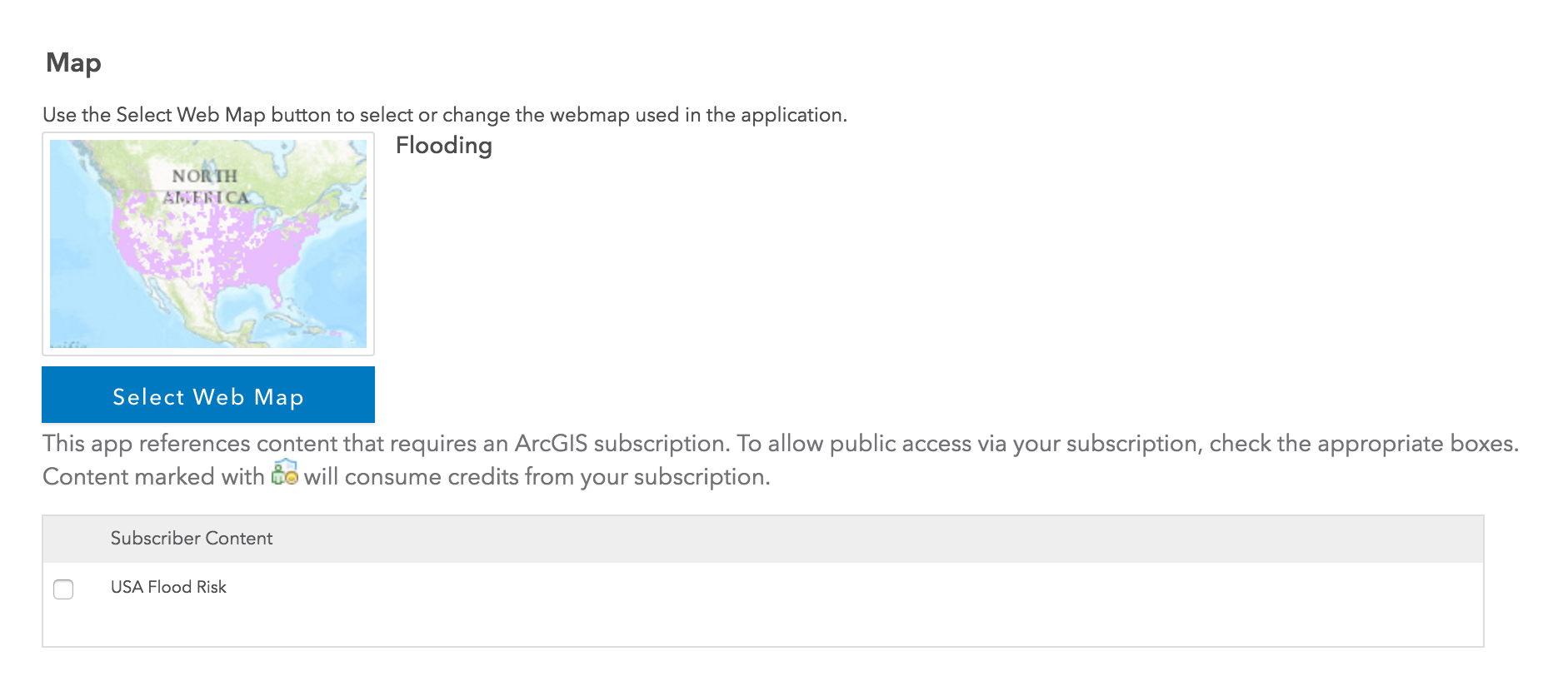
So...if I don't use web appbuilder I just click a checkbox.
If I use web appbuilder then I am using a proxy (that I don't actually have to set up??) but that's probably what the checkbox is doing in the configurable web apps.
I would guess that doesn't have the consume credits icon because it's subscription content but not premium content.
The help page for this (now that I know what to look for!) is Attribute—Web AppBuilder for ArcGIS | ArcGIS
This solves the problem - thank you for the clarification.
- Mark as New
- Bookmark
- Subscribe
- Mute
- Subscribe to RSS Feed
- Permalink
Behind the scenes both scenarios are doing the same thing - creating the proxied url for that resource that is hosted and managed online.
- Mark as New
- Bookmark
- Subscribe
- Mute
- Subscribe to RSS Feed
- Permalink
One option is to share the web map as an app using the Share > Create a Web App option in the ArcGIS Online Map Viewer. When you do that you can configure the app to allow anonymous users to view the Living Atlas content. Here's a screen shot showing the dialog on the app config. Just check the checkbox next to the layer you want to make available then share your app publicly and users won't be prompted to log-in.