- Home
- :
- All Communities
- :
- Products
- :
- ArcGIS Online
- :
- ArcGIS Online Questions
- :
- Re: kml file projection
- Subscribe to RSS Feed
- Mark Topic as New
- Mark Topic as Read
- Float this Topic for Current User
- Bookmark
- Subscribe
- Mute
- Printer Friendly Page
kml file projection
- Mark as New
- Bookmark
- Subscribe
- Mute
- Subscribe to RSS Feed
- Permalink
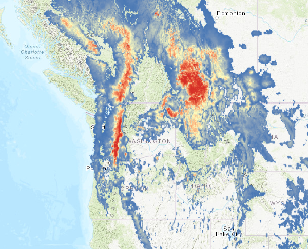
I would like to present raster information within a Story Map. Since this option is not available, as a work-around, I have converted the raster (which originated from a script written in R) to a KML file. When loaded into a Web Map, the projection is incorrect. I have tried:
1) converting the raster file coordinate system (GCS_WGS_1984) directly to a kml file.
1) Changing the coordinate system in the original raster file from GCS_WGS_1984 to WGS_1984_Web_Mercator_Auxiliary_Sphere before conversion
2) Adding the original raster file to the Dataframe where the coordinate system has been stipulated as WGS_1984_Web_Mercator_Auxiliary_Sphere before converting
3) Exporting the data to a new raster (tiff format) stipulating that coordinate system of the new file should be the same as the dataframe (WGS_1984_Web_Mercator_Auxiliary_Sphere).
All of these have exactly the same result - the files are correct within ArcMap before they are converted to a KML file, but once converted and loaded into a Web Map, they are skewed (image below).
Thanks for you help.
- Mark as New
- Bookmark
- Subscribe
- Mute
- Subscribe to RSS Feed
- Permalink
I am having the same issue and have tried some of the solutions you describe. I cannot figure it out. Did you ever find a solution?
- Mark as New
- Bookmark
- Subscribe
- Mute
- Subscribe to RSS Feed
- Permalink
Sorry, no, I never got a satisfactory answer. I ended up converting it to a feature layer, which did not give a very good resolution given the size limits/load times for StoryMaps.
- Mark as New
- Bookmark
- Subscribe
- Mute
- Subscribe to RSS Feed
- Permalink
Replying because I am having the same problem and can't manage to find anything online about it! Hoping someone has an answer out there 😞