- Home
- :
- All Communities
- :
- Products
- :
- ArcGIS Online
- :
- ArcGIS Online Questions
- :
- High resolution basemaps not loading?
- Subscribe to RSS Feed
- Mark Topic as New
- Mark Topic as Read
- Float this Topic for Current User
- Bookmark
- Subscribe
- Mute
- Printer Friendly Page
High resolution basemaps not loading?
- Mark as New
- Bookmark
- Subscribe
- Mute
- Subscribe to RSS Feed
- Permalink
In the last week, the high resolution basemaps from World Imagery are noticeably less detailed. Is there a reason this is happening?
- Mark as New
- Bookmark
- Subscribe
- Mute
- Subscribe to RSS Feed
- Permalink
Adam,
Can you give examples of where these maps were not loading? What parts of the world, what basemaps were you using, can you supply screenshots, etc.?
- Mark as New
- Bookmark
- Subscribe
- Mute
- Subscribe to RSS Feed
- Permalink
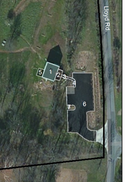
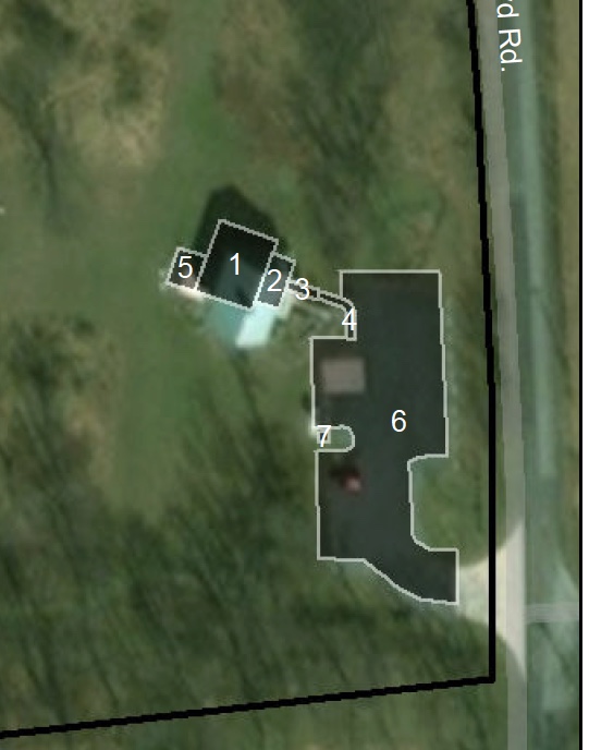
These maps are not loading for Jefferson County West Virginia. Previously-- the imagery adjusted to high resolution when I zoomed closer to a feature. The basemaps I was adding are the World imagery files that are accessible from Add Data--> Basemaps.
It's been very frustrating because I previously created maps using this imagery and it suddenly changed-- now shapefiles I digitized aren't even lining up to features on the ground, regardless of of how they are projected or the Data Frame projection.
Attached are an example of the reduced quality of the aerial imagery. This is not just on my computer, I have asked colleagues and they also have noticed the difference. I've tried moving closer to the modem, using different WiFi connections, etc.
- Mark as New
- Bookmark
- Subscribe
- Mute
- Subscribe to RSS Feed
- Permalink
I've seen a thread on gis.stackexchange regarding this issue as well.
arcgis desktop - ESRI Basemap No High Resolution - Geographic Information Systems Stack Exchange
- Mark as New
- Bookmark
- Subscribe
- Mute
- Subscribe to RSS Feed
- Permalink
This is an issue but I am thinking that it is likely out of anyone's control except for Esri. Digitzing off of a basemap should always come with the caveat that basemaps are rarely perfect and can change (like you have seen).
This issue might be better served in a place like Imagery and Remote Sensing.
This website might offer a place to leave feedback on such issues as these: How To: Provide feedback on basemaps in www.ArcGIS.com
- Mark as New
- Bookmark
- Subscribe
- Mute
- Subscribe to RSS Feed
- Permalink
Here's one of the tiles I pulled:
https://server.arcgisonline.com/ArcGIS/rest/services/World_Imagery/MapServer/tile/19/199917/148656
39.241869, -77.925607
Here's the service desc:
According to the description, the continental US should have 1 foot resolution (0.3 m):
World Imagery provides one meter or better satellite and aerial imagery in many parts of the world and lower resolution satellite imagery worldwide. The map includes 15m TerraColor imagery at small and mid-scales (591M down to 72k) and 2.5m SPOT Imagery (288k to 72k) for the world, and USGS 15m Landsat imagery for Antarctica. The map features 0.3m resolution imagery in the continental United States and 0.6m resolution imagery in parts of Western Europe from Digital Globe. Recent 1m USDA NAIP imagery is available in select states of the US. In other parts of the world, 1 meter resolution imagery is available from GeoEye IKONOS, AeroGRID, and IGN Spain. Additionally, imagery at different resolutions has been contributed by the GIS User Community. For more information on this map, including the terms of use, visit us online.
That sure doesn't look like sub meter resolution! The source text lists:
Commonwealth of Virginia, County of Loudoun, Microsoft
- Mark as New
- Bookmark
- Subscribe
- Mute
- Subscribe to RSS Feed
- Permalink
My digitization was ground-truthed, so it's more a frustration with presentation quality than accuracy, or dependence on the basemap. I can get other high resolution aerials, but on the the property I am dealing with, the buildings were recently built and I haven't been able to find another layer that shows them in place. We pay for the basemap service as part of the subscription and as noted in Chris' comment, it's supposed to be there. I'm curious what happened and if it will return. If not, I need to find another solution. I appreciate the link, I have submitted my issue to ESRI and will update once they respond. Thanks!
- Mark as New
- Bookmark
- Subscribe
- Mute
- Subscribe to RSS Feed
- Permalink
I wanted to share a blog post regarding the recent US updates to the World Imagery basemap. The post contains some of the reasoning behind the update as well links to additional/alternative services where hopefully you can find a solution.
What’s New in World Imagery Basemap (January 2018) | ArcGIS Blog
I hope this helps!
- Mark as New
- Bookmark
- Subscribe
- Mute
- Subscribe to RSS Feed
- Permalink
I am also having trouble with the imagery basemap - working in central Brazil, in a place I've used this layer many times before. Yesterday and today when I zoom in closer than 1:4,000, the layer may or may not display completely, but then all the vector layers above it fail to render, and the 'Cancelled' message shows up in the lower left corner of ArcMap 10.6. This is a new issue that I have not had in years of using this same basemap at these same locations and same high resolutions... has something changed with my latest update to 10.6.0.8321? Or have they monkeyed with the database?
- Mark as New
- Bookmark
- Subscribe
- Mute
- Subscribe to RSS Feed
- Permalink
I am having this problem also, only I'm seeing it with the World Terrain Base map. The resolution is awful when zoomed in to about 1:4000. I'm using arcgis desktop 10.5.1.