- Home
- :
- All Communities
- :
- Products
- :
- ArcGIS Online
- :
- ArcGIS Online Questions
- :
- Re: Geoinquiries
- Subscribe to RSS Feed
- Mark Topic as New
- Mark Topic as Read
- Float this Topic for Current User
- Bookmark
- Subscribe
- Mute
- Printer Friendly Page
Geoinquiries
- Mark as New
- Bookmark
- Subscribe
- Mute
- Subscribe to RSS Feed
- Permalink
hello,
i'm noticing that one of the geoinquiries seems to be missing things or not linking to the correct info. at least, that's how it seems. it may be user error as i'm fairly new to this, but a few examples...
#13 for Adv Human Geog
- the HDI Very High layer seems to be missing many countries (germany, france, england)
- for that matter, i guess all the layers (low, med, high) are missing countries as there are only a few countries in each category
- there is a question ("Which middle development country is an example of a newly industrializing country? ") on that inquiry that doesn't have a corresponding layer that might help us answer it.
- when i click on 'description' under any of the layers, it takes me to a random layer description that doesn't relate as far as i can tell.
i haven't checked them all, but just wondering if these are typically kept pretty updated or if they are known to be i bit glitchy. they seem like a really valuable resource, but if they aren't maintained i don't want to use them with students.
thank you very much.
Jeb
- Mark as New
- Bookmark
- Subscribe
- Mute
- Subscribe to RSS Feed
- Permalink
Hi Jeb.
Thanks for your interest in GeoInquiries.
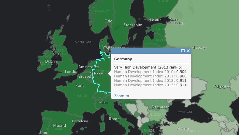
(Bullet 1-2): It sounds like you had a bad map load or something hiccuped while you were loading the map. I just checked the map and all seems to be loading normally. The HDI layer for Germany for example is below. Try loading the map again alternatively, try loading the map in Chrome Incognito to force the data to refresh.

(Bullet 3): It looks like you have an old version of the activity. GeoInquiries and maps are regularly updated. Please see www.esri.com/geoinquiries for the latest activities and maps. A "Q1 2018" date stamp on the bottom of the second page is the most current activity as of today.
(Bullet 4): The description link takes you to the REST service page (technical info about the layer).
If you have additional questions, please free free to send them directly to the development team at geoinquiries@esri.com . You will likely also find more community support in this forum:
- Mark as New
- Bookmark
- Subscribe
- Mute
- Subscribe to RSS Feed
- Permalink
Hi Tom,
Thanks so much for the reply. I did as you suggested but I think I'm still having an issue. The geoinquiry in question does have the Q1 2018 stamp on the instruction sheet. But when I click on the map link toward the top of page 1, I get to a map that seems to be giving me the same issues.
I've included a screenshot that shows I have all 3 content areas checked (hi, med, low), but as the map shows, only a handful of countries are actually falling into any of the 3 categories. I feel sure there's something I'm doing wrong. Any thoughts?

Thank you again for your help.
- Mark as New
- Bookmark
- Subscribe
- Mute
- Subscribe to RSS Feed
- Permalink
Hi Jeb.
Sorry about the confusion on this.
The GeoInquiry and map you are seeing (Comparing Country Development) only shows a subset of HDI data. This was done to focus the activity and highlight select countries. You'll see by clicking on a country with a dataset that additional data like education, GDP, etc. are available in the pop-up window. These attributes will allow the remainder of the activity to be completed. This is a great activity for stepping into HDI. If you'd like to see the full HDI dataset, explore the activity The Human Development Index, also in the same collection.
Tom
AP Human Geography GeoInquiry collection at http://esriurl.com/HumanGeoInquiries
- Mark as New
- Bookmark
- Subscribe
- Mute
- Subscribe to RSS Feed
- Permalink
Got it, thank you so much Tom.