- Home
- :
- All Communities
- :
- Products
- :
- ArcGIS Online
- :
- ArcGIS Online Questions
- :
- Re: Flow Direction Arrows - ArcGIS Online
- Subscribe to RSS Feed
- Mark Topic as New
- Mark Topic as Read
- Float this Topic for Current User
- Bookmark
- Subscribe
- Mute
- Printer Friendly Page
Flow Direction Arrows - ArcGIS Online
- Mark as New
- Bookmark
- Subscribe
- Mute
- Subscribe to RSS Feed
- Permalink
Any thoughts on how to get this to work or what may be causing this?
Thanks in advanced and God bless!
Matthew
- Mark as New
- Bookmark
- Subscribe
- Mute
- Subscribe to RSS Feed
- Permalink
http://resources.arcgis.com/en/help/main/10.2/index.html#//015400000393000000
My guess is that the symbol you're using to draw the lines in desktop is not supported when publishing the data to the web.
For line layers, simple line symbols are supported. If other symbols are used, the feature service converts them to a simple line symbol that best represents the original symbol. For example, a cartographic line symbol in the map document may be drawn as a simple solid line in a feature service client. If a line symbol is complex or has multiple layers, the feature service downgrades the line to best represent the original line symbol.
Thanks,
Mike
- Mark as New
- Bookmark
- Subscribe
- Mute
- Subscribe to RSS Feed
- Permalink
John Schulz
GIS Analyst
Geospatial Analysis & Data Development Services
John.Schulz@austintexas.gov
- Mark as New
- Bookmark
- Subscribe
- Mute
- Subscribe to RSS Feed
- Permalink
This may help.
http://resources.arcgis.com/en/help/main/10.2/index.html#//015400000393000000
My guess is that the symbol you're using the draw the lines in desktop is not supported when publishing the data to the web.
Thanks,
Mike
Mike,
I'm having the same issue. I'm publishing to an .sd file and using the FeatureServer URL to create a map service online and when using flow arrows it appears the flow arrows draw a million times per line feature creating a thick black line. Black because that the color of the flow arrows. Any help is greatly appreciated. Thanks.
- Mark as New
- Bookmark
- Subscribe
- Mute
- Subscribe to RSS Feed
- Permalink
I could really use this for our sewer system lines as well. I know it's possible if you have your own server, so why can this not be implemented on AGOL hosted features?
- Mark as New
- Bookmark
- Subscribe
- Mute
- Subscribe to RSS Feed
- Permalink
It's a technical limitation. A feature layer (hosted or not) passes the feature geometry to the client app (browser, mobile device, desktop app) and the client draws it. Web browsers don't have the ability to draw complex line symbols.
thanks,
Mike
- Mark as New
- Bookmark
- Subscribe
- Mute
- Subscribe to RSS Feed
- Permalink
This feature service has arrows on it:
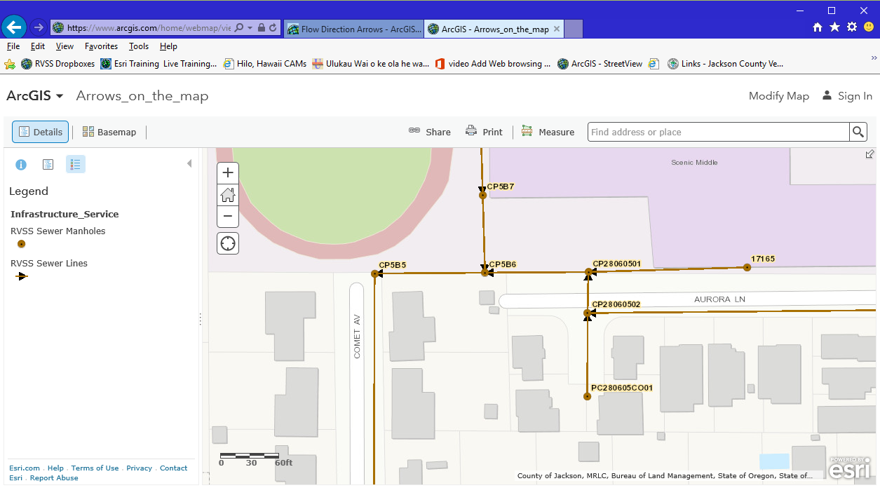
I think it has something to do with being in a "map image layer", which if I understand correctly is only available if you have your own server.
- Mark as New
- Bookmark
- Subscribe
- Mute
- Subscribe to RSS Feed
- Permalink
Yes, map image layers are drawn by the server and return an image of the drawing to a client application. You do need your own server to host a map image layer.
- Mark as New
- Bookmark
- Subscribe
- Mute
- Subscribe to RSS Feed
- Permalink
Is there any resolution to this?
- Mark as New
- Bookmark
- Subscribe
- Mute
- Subscribe to RSS Feed
- Permalink
oThis geonet thread gives info on how to symbolize properly:
- https://community.esri.com/thread/52380
- Show Direction of Route with Arrow Symbol???
- Question asked by Kevin Doyle on May 30, 2012
Initially, I added specific service url's to the mxd from another published service.
For example, http://domain/arcgis/rest/services/SanitarySystem/ServiceName/MapServer/10
I had this layer grouped in the mxd with another layer.
Published it using ArcGIS server as the host.
The symbology was ok in the rest end point viewer.
When I added the layer url to a web map on agol, it turned into a solid black line.
I tried adding the group parent url to the web map, but the web map shows an error:
The layer is not a supported type and cannot be added to the map.
Three possible solutions:
1
add the whole server url to the web map
http://domain/arcgis/rest/services/SanitarySystem/ServiceName/MapServer
- One con of doing it this way is that if you have other layers in the web map, the web map places this towards the bottom of the layer list.
- The user cannot reorder it.
- If there are non-transparent polygons on top of this map service, then it will be covered.
Also, I attempted to remove the unnecessary layers from the web map, but it seems that once you add the MapServer url, you cannot remove the individual index layers of that map service.
2
Symbolize the line arrow by itself (NOT in a group layer, NOR any other layers in the mxd) in a source mxd.
Publish as a map service using ArcGIS server.
Add the Map service url (http://domain/arcgis/rest/services/SanitarySystem/ServiceName/MapServer) to web map
- One con of doing it this way is that if you have other layers in the web map, the web map places this towards the bottom of the layer list.
- The user cannot reorder it.
- If there are non-transparent polygons on top of this map service, then it will be covered.
Do not add the 'http://domain/arcgis/rest/services/SanitarySystem/ServiceName/MapServer/0'
3
use any basic line symbol at the mxd, with color of choice, and no arrows.
use agol to accomplish arrow symbology
change style
select a drawing style
symbols
Arrow
2 pixels width
choose the arrow pointing to the right (third one down).