- Home
- :
- All Communities
- :
- Products
- :
- ArcGIS Online
- :
- ArcGIS Online Documents
- :
- Overwrite ArcGIS Online Feature Service using Trun...
- Subscribe to RSS Feed
- Mark as New
- Mark as Read
- Bookmark
- Subscribe
- Printer Friendly Page
Overwrite ArcGIS Online Feature Service using Truncate and Append
Overwrite ArcGIS Online Feature Service using Truncate and Append
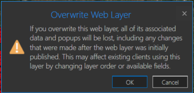
You may have a need to overwrite an ArcGIS Online hosted feature service due to feature and/or attribute updates. However, this could cause some data loss such as pop-ups, symbology changes, etc in the hosted feature service. For example, you will receive a warning about this when you try to overwrite a feature service in ArcGIS Pro:
One way around this is to use the ArcGIS API for Python. If you are the data owner, or Administrator, you can truncate the feature service, and then append data. This is essentially an overwrite of the feature service. The below script will do this by specifying a local feature class and the item id of the feature service you wish to update. The script will then execute the following steps:
- export the feature class to a temporary File Geodatabase
- zip the File Geodatabase
- upload the zipped File Geodatabase to AGOL
- truncate the feature service
- append the zipped File Geodatabase to the feature service
- delete the uploaded zipped File Geodatabase in AGOL
- delete the local zipped File Geodatabase
- delete the temporary File Geodatabase
Here is an explanation of the script variables:
- username = ArcGIS Online username
- password = ArcGIS Online username password
- fc = path to feature class used to update feature service
- fsItemId = the item id of the ArcGIS Online feature service
- featureService = True if updating a Feature Service, False if updating a Hosted Table
- hostedTable = True is updating a Hosted Table, False if updating a Feature Service
- layerIndex = feature service layer index
- disableSync = True to disable sync, and then re-enable sync after append, False to not disable sync. Set to True if sync is not enabled
- updateSchema = True will remove/add fields from feature service keeping schema in-sync, False will not remove/add fields
- upsert = True will not truncate the feature service, requires a field with unique values
- uniqueField = Field that contains unique values
Note: For this script to work, the field names in the feature class must match the field names in the hosted feature service. The hosted feature service can have additional fields, though.
Video
Script
import arcpy, os, time, uuid, arcgis
from zipfile import ZipFile
from arcgis.gis import GIS
import arcgis.features

# Variables
username = "jskinner_rats"                                    # AGOL Username
password = "********"                                         # AGOL Password
fc = r"c:\DB Connections\[email protected]\GIS.Parcels"        # Path to Feature Class
fsItemId = "a0ad52a76ded483b82c3943321f76f5a"                 # Feature Service Item ID to update
featureService = True                                         # True if updating a Feature Service, False if updating a Hosted Table
hostedTable = False                                           # True is updating a Hosted Table, False if updating a Feature Service
layerIndex = 0                                                # Layer Index
disableSync = True                                            # True to disable sync, and then re-enable sync after append, False to not disable sync.  Set to True if sync is not enabled
updateSchema = True                                           # True will remove/add fields from feature service keeping schema in-sync, False will not remove/add fields
upsert = True                                                 # True will not truncate the feature service, requires a field with unique values
uniqueField = 'PIN'                                           # Field that contains unique values

# Environment Variables
arcpy.env.overwriteOutput = True
arcpy.env.preserveGlobalIds = True


def zipDir(dirPath, zipPath):
    '''
    Zips File Geodatabase
    Args:
        dirPath: (string) path to File Geodatabase
        zipPath: (string) path to where File Geodatabase zip file will be created

    Returns:

    '''
    zipf = ZipFile(zipPath , mode='w')
    gdb = os.path.basename(dirPath)
    for root, _ , files in os.walk(dirPath):
        for file in files:
            if 'lock' not in file:
               filePath = os.path.join(root, file)
               zipf.write(filePath , os.path.join(gdb, file))
    zipf.close()


def updateFeatureServiceSchema():
    '''
    Updates the hosted feature service schema
    Returns:

    '''
    # Get required fields to skip
    requiredFields = [field.name for field in arcpy.ListFields(fc) if field.required]

    # Get feature service fields
    print("Get feature service fields")
    featureServiceFields = {}
    for field in fLyr.manager.properties.fields:
        if field.type != 'esriFieldTypeOID' and 'Shape_' not in field.name:
            featureServiceFields[field.name] = field.type

    # Get feature class/table fields
    print("Get feature class/table fields")
    featureClassFields = {}
    arcpy.env.workspace = gdb
    if hostedTable == True:
        for field in arcpy.ListFields(fc):
            if field.name not in requiredFields:
                featureClassFields[field.name] = field.type
    else:
        for field in arcpy.ListFields(fc):
            if field.name not in requiredFields:
                featureClassFields[field.name] = field.type

    minusSchemaDiff = set(featureServiceFields) - set(featureClassFields)
    addSchemaDiff = set(featureClassFields) - set(featureServiceFields)

    # Delete removed fields
    if len(minusSchemaDiff) > 0:
        print("Deleting removed fields")
        for key in minusSchemaDiff:
            print(f"\tDeleting field {key}")
            remove_field = {
                "name": key,
                "type": featureServiceFields[key]
            }
            update_dict = {"fields": [remove_field]}
            fLyr.manager.delete_from_definition(update_dict)

    # Create additional fields
    fieldTypeDict = {}
    fieldTypeDict['Date'] = 'esriFieldTypeDate'
    fieldTypeDict['Double'] = 'esriFieldTypeDouble'
    fieldTypeDict['Integer'] = 'esriFieldTypeInteger'
    fieldTypeDict['String'] = 'esriFieldTypeString'
    if len(addSchemaDiff) > 0:
        print("Adding additional fields")
        for key in addSchemaDiff:
            print(f"\tAdding field {key}")
            if fieldTypeDict[featureClassFields[key]] == 'esriFieldTypeString':
                new_field = {
                    "name": key,
                    "type": fieldTypeDict[featureClassFields[key]],
                    "length": [field.length for field in arcpy.ListFields(fc, key)][0]
                }
            else:
                new_field = {
                    "name": key,
                    "type": fieldTypeDict[featureClassFields[key]]
                }

            update_dict = {"fields": [new_field]}
            fLyr.manager.add_to_definition(update_dict)


def divide_chunks(l, n):
    '''

    Args:
        l: (list) list of unique IDs for features that have been deleted
        n: (integer) number to iterate by

    Returns:

    '''
    # looping till length l
    for i in range(0, len(l), n):
        yield l[i:i + n]

if __name__ == "__main__":
    # Start Timer
    startTime = time.time()

    # Create GIS object
    print("Connecting to AGOL")
    gis = GIS("https://www.arcgis.com", username, password)

    # Create UUID variable for GDB
    gdbId = str(uuid.uuid1())

    print("Creating temporary File Geodatabase")
    gdb = arcpy.CreateFileGDB_management(arcpy.env.scratchFolder, gdbId)[0]

    # Export featureService classes to temporary File Geodatabase
    fcName = os.path.basename(fc)
    fcName = fcName.split('.')[-1]
    print(f"Exporting {fcName} to temp FGD")
    if featureService == True:
        arcpy.conversion.FeatureClassToFeatureClass(fc, gdb, fcName)
    elif hostedTable == True:
        arcpy.conversion.TableToTable(fc, gdb, fcName)

    # Zip temp FGD
    print("Zipping temp FGD")
    zipDir(gdb, gdb + ".zip")

    # Upload zipped File Geodatabase
    print("Uploading File Geodatabase")
    fgd_properties={'title':gdbId, 'tags':'temp file geodatabase', 'type':'File Geodatabase'}
    if arcgis.__version__ < '2.4.0':
        fgd_item = gis.content.add(item_properties=fgd_properties, data=gdb + ".zip")
    elif arcgis.__version__ >= '2.4.0':
        root_folder = gis.content.folders.get()
        fgd_item = root_folder.add(item_properties=fgd_properties, file=gdb + ".zip").result()

    # Get featureService/hostedTable layer
    serviceLayer = gis.content.get(fsItemId)
    if featureService == True:
        fLyr = serviceLayer.layers[layerIndex]
    elif hostedTable == True:
        fLyr = serviceLayer.tables[layerIndex]

    # Append features from featureService class/hostedTable
    if upsert == True:
        # Check if unique field has index
        indexedFields = []
        for index in fLyr.manager.properties['indexes']:
            indexedFields.append(index['fields'])
        if uniqueField not in indexedFields:
            print(f"{uniqueField} does not have unique index; creating")
            fLyr.manager.add_to_definition({
                "indexes": [
                    {
                        "fields": f"{uniqueField}",
                        "isUnique": True,
                        "description": "Unique field for upsert"
                    }
                ]
            })

        # Schema Sync
        if updateSchema == True:
            updateFeatureServiceSchema()

        # Append features
        print("Appending features")
        fLyr.append(item_id=fgd_item.id, upload_format="filegdb", upsert=True, upsert_matching_field=uniqueField, field_mappings=[])

        # Delete features that have been removed from source
        # Get list of unique field for feature class and feature service
        entGDBList = [row[0] for row in arcpy.da.SearchCursor(fc, [uniqueField])]
        fsList = [row[0] for row in arcpy.da.SearchCursor(fLyr.url, [uniqueField])]
        s = set(entGDBList)
        differences = [x for x in fsList if x not in s]

        # Delete features in AGOL service that no longer exist
        if len(differences) > 0:
            print('Deleting differences')
            if len(differences) == 1:
                if type(differences[0]) == str:
                    features = fLyr.query(where=f"{uniqueField} = '{differences[0]}'")
                else:
                    features = fLyr.query(where=f"{uniqueField} = {differences[0]}")
                fLyr.edit_features(deletes=features)
            else:
                chunkList = list(divide_chunks(differences, 1000))
                for list in chunkList:
                    chunkTuple = tuple(list)
                    features = fLyr.query(where=f'{uniqueField} IN {chunkTuple}')
                    fLyr.edit_features(deletes=features)

    else:
        # Schema Sync
        if updateSchema == True:
            updateFeatureServiceSchema()

        # Truncate Feature Service
        # If views exist, or disableSync = False use delete_features.  OBJECTIDs will not reset
        flc = arcgis.features.FeatureLayerCollection(serviceLayer.url, gis)
        hasViews = False
        try:
            if flc.properties.hasViews == True:
                print("Feature Service has view(s)")
                hasViews = True
        except:
            hasViews = False

        if hasViews == True or disableSync == False:
            # Get Min OBJECTID
            minOID = fLyr.query(out_statistics=[
                {"statisticType": "MIN", "onStatisticField": "OBJECTID", "outStatisticFieldName": "MINOID"}])
            minOBJECTID = minOID.features[0].attributes['MINOID']

            # Get Max OBJECTID
            maxOID = fLyr.query(out_statistics=[
                {"statisticType": "MAX", "onStatisticField": "OBJECTID", "outStatisticFieldName": "MAXOID"}])
            maxOBJECTID = maxOID.features[0].attributes['MAXOID']

            # If more than 2,000 features, delete in 2000 increments
            print("Deleting features")
            if maxOBJECTID != None and minOBJECTID != None:
                if (maxOBJECTID - minOBJECTID) > 2000:
                    x = minOBJECTID
                    y = x + 1999
                    while x < maxOBJECTID:
                        query = f"OBJECTID >= {x} AND OBJECTID <= {y}"
                        fLyr.delete_features(where=query)
                        x += 2000
                        y += 2000
                # Else if less than 2,000 features, delete all
                else:
                    print("Deleting features")
                    fLyr.delete_features(where="1=1")

        # If no views and disableSync is True: disable Sync, truncate, and then re-enable Sync.  OBJECTIDs will reset
        elif hasViews == False and disableSync == True:
            if flc.properties.syncEnabled == True:
                print("Disabling Sync")
                properties = flc.properties.capabilities
                updateDict = {"capabilities": "Query", "syncEnabled": False}
                flc.manager.update_definition(updateDict)
                print("Truncating Feature Service")
                fLyr.manager.truncate()
                print("Enabling Sync")
                updateDict = {"capabilities": properties, "syncEnabled": True}
                flc.manager.update_definition(updateDict)
            else:
                print("Truncating Feature Service")
                fLyr.manager.truncate()

        print("Appending features")
        fLyr.append(item_id=fgd_item.id, upload_format="filegdb", upsert=False, field_mappings=[])

    # Delete Uploaded File Geodatabase
    print("Deleting uploaded File Geodatabase")
    fgd_item.delete()

    # Delete temporary File Geodatabase and zip file
    print("Deleting temporary FGD and zip file")
    arcpy.Delete_management(gdb)
    os.remove(gdb + ".zip")

    endTime = time.time()
    elapsedTime = round((endTime - startTime) / 60, 2)
    print("Script finished in {0} minutes".format(elapsedTime))
Updates
3/3/2023: Added the ability to add/remove fields from feature service keeping schemas in-sync. For example, if a field(s) is added/removed from the feature class, it will also add/remove the field(s) from the feature service
10/17/2024: Added upsert functionality. Deleted features/rows from the source feature class/table will also be deleted from feature service. This is helpful if you do not want your feature service truncated at all. In the event of a failed append, the feature service will still contain data. A prerequisite for this is for the data to have a unique id field.
I am not very good in python syntax. Exactly where in the beginning do you put theese lines? I tried to add it in line 4, before the variables-definition. Did not work. Tried to put it in appr. line 78, just after the definitions, did not work, then I got the same error as before.
Could I ask you to repost the whole script with theese lines placed correctly?
I dont know if this helps, but I did run the script with only one service, started out with a blank <scratch>-folder. The delete-function still crashes, but its only to delete the .zip-file that crashes. The .gdb-folder is removed.
The zip-file is obviolus used by another process.
Traceback (most recent call last):
File "C:\Kart\Plan\geonorge\Skript_Nedlasting\Python_Skript\OppdaterPlandataAGO\RPF12_OppdaterReguleringsplanVN2_Arealformal.py", line 289, in <module>
os.remove(gdb + ".zip")
PermissionError: [WinError 32] Prosessen får ikke tilgang til filen fordi den brukes av en annen prosess: 'C:\\Users\\35450\\AppData\\Local\\Temp\\scratch\\724e340d-321b-11f0-805f-2079182894fb.gdb.zip'
@JakeSkinner Came across this post while looking to accomplish a similar workflow and I really appreciate the hard work you've put into the initial code as well as trouble shooting with other users.
My only questions are as follows:
Would your method for completing the Truncate operation break all downloaded offline areas attached to the hosted feature layer due to disabling and re-enabling the sync defeating the purpose of the sync itself? Why would you not utilize an upsert operation to update and append any new records so that users are not constantly having to remove and redownload their offline map areas?
looking forward to discussing this with you soon.

@SveinungBertnesRåheim I am also having the same issue. Once it gets to the step of deleting the .zip file, I also get this permission error. It started happening at the end of May for me and I've been running this script daily for months with no issue.
PermissionError: [WinError 32] The process cannot access the file because it is being used by another process: The way I've been using this script is as a module. As a workaround, I removed the os.remove() line from the module. I also made sure the temp gdb is named with the feature service item ID and not a random name. Then, in the main script, right before the overwrite function is used, I added the os.remove() line if the temp gdb exists. Not perfect but it works for now.
os.remove(gdb + ".zip")
@JakeSkinner I just tried this script for the first time and I'm getting an Error Code 500 during the Append stage.
I exported an FGBD from my enterprise SDE and shared to AGOL, having it create a service. Left all settings on the resulting FeatureServer as default. Ran the script with the following Variables and got the Error at the bottom. Any thoughts I where I may have gone wrong?
EDIT: Forgot to mention, though it may be obvious from where the script failed, that there's a new FGDB in my AGOL account and the FeatureServer is now empty (no records)
# Variables
username = "***********"
password = "***********"
fc = r"***********"
fsItemId = "***********"
featureService = True
hostedTable = False
layerIndex = 0
disableSync = True
updateSchema = False
upsert = False
uniqueField = 'PIN'
Connecting to AGOL
Creating temporary File Geodatabase
Exporting CU_REC_FACILITIES_POINT to temp FGD
Zipping temp FGD
Uploading File Geodatabase
Truncating Feature Service
Appending features
Traceback (most recent call last):
File "D:\Projects\OPRD_Rec_Features\RecData_Overwrite_RecFacilities.py", line 280, in <module>
fLyr.append(item_id=fgd_item.id, upload_format="filegdb", upsert=False, field_mappings=[])
File "C:\Program Files\ArcGIS\Pro\bin\Python\envs\arcgispro-py3\lib\site-packages\arcgis\features\layer.py", line 2901, in append
return self._check_append_status(res, return_messages)
File "C:\Program Files\ArcGIS\Pro\bin\Python\envs\arcgispro-py3\lib\site-packages\arcgis\features\layer.py", line 2912, in _check_append_status
sres = self._con.get(path=surl, params={"f": "json"})
File "C:\Program Files\ArcGIS\Pro\bin\Python\envs\arcgispro-py3\lib\site-packages\arcgis\gis\_impl\_con\_connection.py", line 862, in get
return self._handle_response(
File "C:\Program Files\ArcGIS\Pro\bin\Python\envs\arcgispro-py3\lib\site-packages\arcgis\gis\_impl\_con\_connection.py", line 1000, in _handle_response
self._handle_json_error(data["error"], errorcode)
File "C:\Program Files\ArcGIS\Pro\bin\Python\envs\arcgispro-py3\lib\site-packages\arcgis\gis\_impl\_con\_connection.py", line 1023, in _handle_json_error
raise Exception(errormessage)
Exception: Unknown Error
(Error Code: 500)
@oregonparksgis if you can share the service to an AGOL Group and invite my account (jskinner_rats), I can take a look.
Thanks, I added you to this group https://arcgis.com/home/group.html?id=48f4700aa9df4a9396beb0d4fecb2b2d
@oregonparksgis since your service has multiple feature classes and attachments, you will be better to execute this script:
I just tested this and it worked successfully.
@JakeSkinner Thanks for providing this alternative solution and testing.
I'm curious about the different methods employed by these two scripts. The one here that we've been commenting/replying on uses the truncate and append approach and has been recommended as a way to avoid issues that may affect previously applied map functions (symbology. popups, etc.). The other approach that you've recommended for me in your reply uses an overwrite approach but as you noted in the excellent video, it also maintains downstream map functions. So is there any difference in the outcome at say the hosted FeatureService or Web Map level between these two methods when the intent is to keep AGOL hosted data in sync with its on-prem version AND maintain downstream AGOL hosted map/app functions?
@oregonparksgis if you have a service that contains multiple layers or attachments, you should use the overwrite approach.
@JakeSkinner Thanks, that's interesting. I wasn't able to get the overwrite from aprx script to work either, it also threw a 500 error.
However, I was able to use the truncate/append approach you outlined here by grabbing the most important sections from your code, and run through the service layers and FeatureClasses in the uploaded GDB in series and it is working great.
I really appreciate your effort and sharing since I wouldn't have been able to find the correct method on my own given all the noise out there on this.
we've started to get 500 errors when doing the append i have tried from both Pro and AGOL Notebooks it seems to be really slow to get to that point also.
anyone else?
Hey @JakeSkinner ,
I use this code all the time and it works great. The one issue that I may face in the near future is that my organization is moving to a SAML approach to logging into AGOL / Portal.
Traditionally I used my Named User login to get access to:
gis = GIS("https://www.arcgis.com", username, password)
If I'm being logged in automatically, how do I go about executing the above code?
Any suggestions or direction would be greatly appreciated.
Thanks Jake.
Cheers!
~Dan
@DJB you can create an API key in AGOL. Once you have the key, you can authenticate to AGOL using this. Ex:
apiKey = 'AAPTxy8BH1VEsoebNVZXo8HurALPt8A8rXQeIUC-G0MzFj7nMpBAt3K7HFJHncoo32Vcbc7tQ1nwjOXtJ1gGR5HkMmM88zm_zHNoOAVg6DUGaBeVYWLFutf4FIL8W-YYsi7N76DHsmoeNfbkB41VUaurr_1FbR7S1IQJU339'

gis = GIS('https://www.arcgis.com', api_key=apiKey)- « Previous
- Next »