Turn on suggestions
Auto-suggest helps you quickly narrow down your search results by suggesting possible matches as you type.
Cancel
- Home
- :
- All Communities
- :
- Products
- :
- ArcGIS Network Analyst
- :
- ArcGIS Network Analyst Questions
- :
- Re: Service Area Problem - Polygon generation inco...
Options
- Subscribe to RSS Feed
- Mark Topic as New
- Mark Topic as Read
- Float this Topic for Current User
- Bookmark
- Subscribe
- Mute
- Printer Friendly Page
Service Area Problem - Polygon generation inconsistent
Subscribe
8619
6
02-22-2012 02:56 PM
02-22-2012
02:56 PM
- Mark as New
- Bookmark
- Subscribe
- Mute
- Subscribe to RSS Feed
- Permalink
Hi everyone!
I am currently working on a walkability analysis identifying various walking distances surrounding schools (200m, 400m, 600m, 800m, 1000m). I have created my own network dataset using multiple datasets and I have not included elevation or direction. This is my first time using the network analyst extension, I have done the tutorials and followed the same process outlined in the tutorials when creating my own network. I am having a problem when solving my service area polygons, most of the polygons that are created look great and are accurate, although some are completely inaccurate and do not represent the appropriate default breaks. Almost as if they cannot traverse properly across the network...?? I have read through most of the threads on this topic already and have not been able to solve my problem. Here is an example of my problem:
[ATTACH=CONFIG]12149[/ATTACH]
This is what I have already ruled out from reading through similar threads:
My facilities are not part of my network dataset.
All of my facilities are located.
There are juctions at every intersection along my network. I also tried dissolve network, still didn't resolve.
I have used the identify tool in the ND extension and all edges reflect the appropriate length.
My polygon generation properties are as follows: Generalised (I have also tried detailed, does not resolve the problem). Trim polygons 50 meters (Have also tried 25 and 100). "Merge by break value" (have tried all others). Overlap type "Rings" (have also tried disks).
Analysis settings as follows. Impedence "Meters" using Shape_Length as my value when creating my ND when selecting evaluators. Default Breaks "200, 400, 600, 800, 1000". Direction "Away from facility". U-Turns "Allowed".
I am lost and am unable to resolve my issue, any assistance to explain why some polygons surrounding facilities are correct and why others are completely inaccurate would be greatly appreciated!
Thanks,
Tom
6 Replies
02-23-2012
06:52 AM
- Mark as New
- Bookmark
- Subscribe
- Mute
- Subscribe to RSS Feed
- Permalink
I'm assuming that the inconsistent polygons are coming from the facilities that only traverse one edge. It is quite likely that the edges that the facilities are located on are disconnected from the nearby edges. If your network dataset has end point connectivity then the edge end points must be identical for there to be connectivity. You can test this by attempting to make a route from one of the inconsistent facility locations to a good facility location. If there is no route then things aren't connected.
Hope this helps!
Doug
Hope this helps!
Doug
02-28-2012
01:34 PM
- Mark as New
- Bookmark
- Subscribe
- Mute
- Subscribe to RSS Feed
- Permalink
Thanks for the reply Doug!
You were right, some of the edges were disconnected so were not traversing correctly.
I managed to resolve this issue by running an integrate with a 2 meter tolerance on my initial feature class, re-created the ND, then re-ran my Service Areas which were created correctly!
Thanks again for your help!
Cheers, Tom.
06-15-2012
09:09 AM
- Mark as New
- Bookmark
- Subscribe
- Mute
- Subscribe to RSS Feed
- Permalink
Tom, did you have trouble with multiple entrances to the schools or streets that abutted the school grounds that could account for different walking areas?
I'm doing almost precisely the same thing and have had a few problems here and there along the same lines that you have. It would be fantastic to talk with you about how you resolved some of the issues.
Cheers!
Jamie
I'm doing almost precisely the same thing and have had a few problems here and there along the same lines that you have. It would be fantastic to talk with you about how you resolved some of the issues.
Cheers!
Jamie
07-15-2012
01:56 PM
- Mark as New
- Bookmark
- Subscribe
- Mute
- Subscribe to RSS Feed
- Permalink
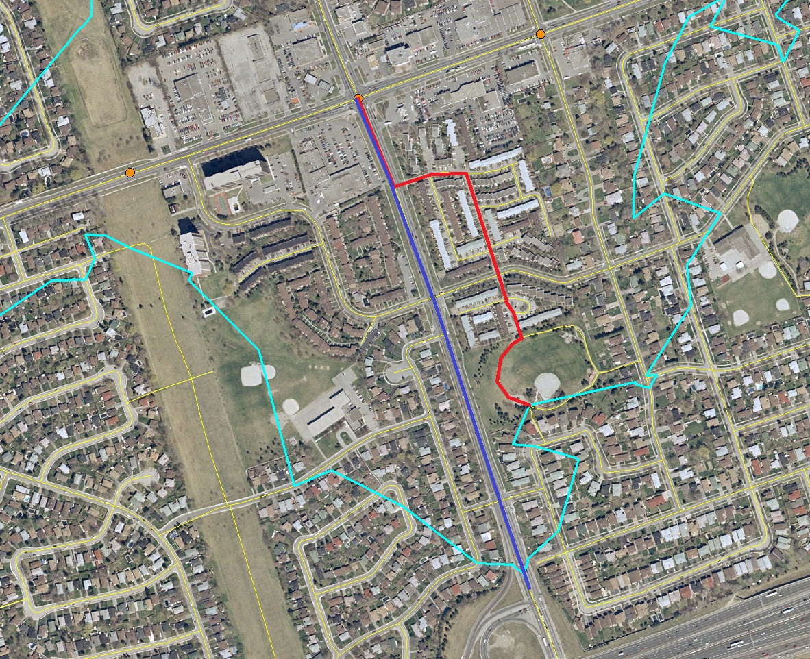
I'm having a similar problem. My polygons are drawing fine but are missing some of their area in certain places. In the photo below (which I've drawn on), the service area should extend to 800m. The blue line shows the correct 800m extent of the service area boundary but the red line is short by about 150m. The problem is occuring in locations where I had to add line segment features to a street network shapefile to include pedestrian paths. The Network Dataset shows that all the network edges connect at junctions so I'm not sure why the polygons don't extend the full 800m along the network. Furthermore, the polygons seem to include portions of the added 'paths' but the results are inconsistent. Any ideas?
Many thanks,
Francois
[ATTACH=CONFIG]16110[/ATTACH]
Many thanks,
Francois
[ATTACH=CONFIG]16110[/ATTACH]
07-16-2012
07:00 AM
- Mark as New
- Bookmark
- Subscribe
- Mute
- Subscribe to RSS Feed
- Permalink
You can bring up the properties of the service area layer and on the line generation tab, turn on the Generate Lines and re-solve.
Are the roads that you added showing up in the service area lines? The polygon will only cover the lines that were traversed by the service area. If they are not traversed then their is some connectivity issue, restriction, etc that is causing the problem.
Jay Sandhu
Are the roads that you added showing up in the service area lines? The polygon will only cover the lines that were traversed by the service area. If they are not traversed then their is some connectivity issue, restriction, etc that is causing the problem.
Jay Sandhu
07-16-2012
10:31 AM
- Mark as New
- Bookmark
- Subscribe
- Mute
- Subscribe to RSS Feed
- Permalink
Hi Jay,
Thanks for your response. I was able to pinpoint problem areas using Line Generation as you suggested. It turns out that the line segments I had drawn in were only connecting to vertices of other line segment and not endpoints. I used the Split Tool on these segments to give them end points and everything is connecting.
Again, thanks for your help.
Francois