- Home
- :
- All Communities
- :
- Products
- :
- ArcGIS Network Analyst
- :
- ArcGIS Network Analyst Questions
- :
- Service Area analysis - holes in service areas
- Subscribe to RSS Feed
- Mark Topic as New
- Mark Topic as Read
- Float this Topic for Current User
- Bookmark
- Subscribe
- Mute
- Printer Friendly Page
Service Area analysis - holes in service areas
- Mark as New
- Bookmark
- Subscribe
- Mute
- Subscribe to RSS Feed
- Permalink
Hello,
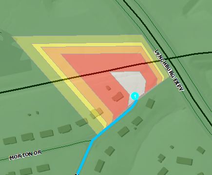
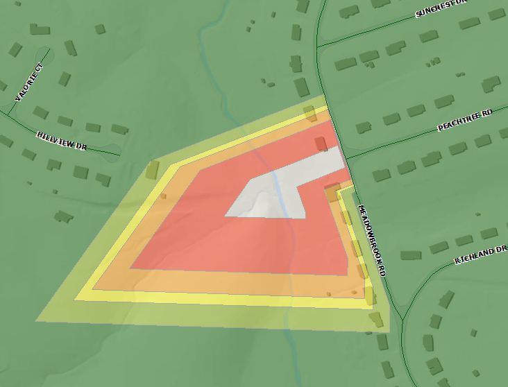
I am attempting to perform a Service Area analysis and am getting unexpected results. I am running the analysis using the detailed polygon generation. My issue is that there are a significant number of holes being generated in the service area results. To test these anomolies, I've run a simple routing problem to verify whether or not these "holes" are routable. In each instance, the routing problem is solved without issue. In the screenshot below, you can see the hole in the service area analysis. The turquoise line is the result of a routing problem. It solved correctly and the cumulative time indicates the entire hole in the service are polygon should be green (<5min drive time.)
I'm sure there is a setting that I am missing, but I've tried everything I can think of. I'd prefer to not user the generalized polygon generation setting, as the results negated a few pockets of "hard to reach" streets.
Any thoughts would be greatly appreciated.
Shaun
ArcGIS Desktop 10.2.2
Windows 7 64bit
Enterprise Geodatabase - SQL Server 2008 R2
- Mark as New
- Bookmark
- Subscribe
- Mute
- Subscribe to RSS Feed
- Permalink
Thanks for the reply Melinda.
The screenshots I provided show a successfully solved routing problem to the segments in question. There doesn't appear to be any issue with their accessibility (restrictions). I also ran the analysis with line generation and the suspect segments were correctly categorized within the appropriate impedance accumulation ranges which indicates the impedance values are correct. I ran statistics on the impedance fields and their aren't any outliers.
It doesn't appear to be an issue with the geometry. I would suspect if the entirety of a road segment is non-traversable, than the resulting hole would encase the entire segment. In our situation, the holes are appearing only at the ends of segments, leaving the majority of the segment within a solved polygon.
Thanks again for the response,
Shaun
- Mark as New
- Bookmark
- Subscribe
- Mute
- Subscribe to RSS Feed
- Permalink
Hey Everyone,
Just wanted to provide an update and let you know we have identified the issue. It is very specific to our data and is not, as I wrongly expected, an issue with the Network Analyst tools. Our street centerline data includes "paper" streets. These centerlines represent the remaining right of way at the end of a street segment or the entirety of a right of way that was dedicated but never built. They are essentially a means of inventorying undeveloped right of way. They are a requirement of our asset management system as they are used to track right of way work orders (all city right of way must be maintained to certain standards within developed areas for safety/insurance/sightliness reasons ). Naturally, these segments are not traversable, and are therefor resulting in holes in the analysis.
Unfortunately our asset management system requires a one-to-one relationship with a feature class so there is no way to have paper streets as a separate feature class at this time. What we'll have to do is export the FDS to a FGDB, delete the paper streets and update the network accordingly whenever we need to run this specific type of analysis.
I really appreciate everyone's feedback and pointing me in the right direction! Wouldn't have figured it out otherwise.
Thanks again,
Shaun
- « Previous
-
- 1
- 2
- Next »
- « Previous
-
- 1
- 2
- Next »