- Home
- :
- All Communities
- :
- Products
- :
- ArcGIS Network Analyst
- :
- ArcGIS Network Analyst Questions
- :
- Re: Closest Facility Error
- Subscribe to RSS Feed
- Mark Topic as New
- Mark Topic as Read
- Float this Topic for Current User
- Bookmark
- Subscribe
- Mute
- Printer Friendly Page
Closest Facility Error
- Mark as New
- Bookmark
- Subscribe
- Mute
- Subscribe to RSS Feed
- Permalink
I am getting a solution error while running the closest facility analysis in ArcGIS Pro
1. I created a network dataset using a road network (in arccatalog), two different points feature layers. I did that in a geodatabase after having all feature classes in a multi-feature dataset. All the feature layers in the gdb have the same geographic coordinate system.
2. Then in ArcGIS Pro, I start a closest facility layer and add the same two point feature layers to incidents and facilities. There are 522 incidents and 28 facilities. I "snap" them so they are connected with the network.
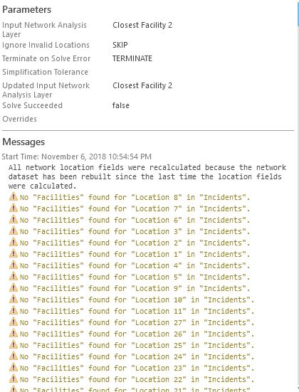
3. Then I run the analysis and I get no solution - i.e. the analysis is not able to find any facility for any incident. (attaching a picture).
Can anyone tell me what could the problem be?
- Mark as New
- Bookmark
- Subscribe
- Mute
- Subscribe to RSS Feed
- Permalink
Most likely there is some issue with the network dataset. Have you done a simple route on that network to make sure you are able to find correct paths?
Also, what does the "two different feature layers" in your description mean?
>I created a network dataset using a road network (in arccatalog), two different points feature layers.
Is it possible that you have included the incident and facility point feature classes as sources in the network dataset? If yes, then if they are not directly on line features, they will become stand alone junctions and your incident and facilities in the closest facility layer will snap to these stand alone junctions and not find any paths in the network. In this case, remove these two point sources from the network dataset and rebuild the network and then create a CF layer and solve.
Jay Sandhu
- Mark as New
- Bookmark
- Subscribe
- Mute
- Subscribe to RSS Feed
- Permalink
thanks!! removing them from sources helped..
- Mark as New
- Bookmark
- Subscribe
- Mute
- Subscribe to RSS Feed
- Permalink
Hi Vikas,
First thing that comes to mind is that the points that you mean to use as facilities and incidents should not be included as sources in the network dataset. Likely this is not causing the solve to not find anything, but without seeing your data, I can't say for certain. And also, it's just best practice to not include point that are meant to be inputs into the analysis as sources in the network dataset.
Second, I think we need to know more about your analysis settings and the network dataset itself. The error "No 'Facilities' found for 'Location X' on 'Incidents'" could indicate several things.
- If you've set an impedance cutoff, then perhaps there are no facilities close enough to the incidents to be reached inside that cutoff. If you think that the incidents should be close enough to facilities, then perhaps the impedance is looking at the wrong field or the numbers in that field are not correct.
- There could be a lot of connectivity problems in the network dataset, so that once the route leaves the incidents, it gets stuck on a street and can't move off of it. These problems could be caused by gaps or connecting at midpoints or other things. You'll want to check your connectivity policy on the network dataset and make sure it is the right one. Setting up a topology on your streets and employing rules like Must Not Overlap, Must Not Self Overlap, Must Not Self Intersect, Must Not Intersect or Touch Interior (just as examples, you can choose which ever rules are most appropriate for your data). Though if you use elevation values, you'll also need to check to make sure that the z values or elevation field values at intersections match. While you may not use Any Vertex connectivity, I like the article Problem: Connectivity isn't established properly when using an Any Vertex connectivity policy and el... explains how elevation works.
A tool I find very helpful for troubleshooting connectivity issues is the Network Identify tool, which right now is only in ArcMap, not Pro (though it is planned to get the tool into Pro). So you'd have to switch to ArcMap to use that.
So I'd start there, with checking your analysis settings and doing a QA on your network dataset to make sure the connectivity of the streets is correct. I hope this helps!
-Rachel
- Mark as New
- Bookmark
- Subscribe
- Mute
- Subscribe to RSS Feed
- Permalink
Thank Rachel!
Removing the points from the network dataset sources helped. But I had done that when I read it as a suggestion on one of thiese forum questions..
I am still struggling with what I am essentially trying to do. May be you can help.
My network is a very simple one. Basically a simple road network throughout the country and then I want to connect one set of points with another. Length is what I have used as the impedance. Other than the length - the route edges also have some descriptors like speedclass and speed. I want to eventually have these speed classes recorded for the routes found after the "closest facility" analysis. I was told on this forum to use "copy traversed source features". I used that tool... but all I am able to get are the separate lengths of all the edges along every route. I want to know the speedclasses as well (which I had added as network elements during creating the dataset.
- Mark as New
- Bookmark
- Subscribe
- Mute
- Subscribe to RSS Feed
- Permalink
Hi Vikas,
I'm glad that removing the incidents and facilities as sources of your network dataset helped. So are you still getting the error that no facilities were found for your incidents?
As to what you are trying to do, if I'm understanding it correctly, if you like the output routes that the CF solver generates, you could run the "Copy Traversed Source Features" tool to get all the individual road segments, then do a spatial join with them back to the original street segments, so that you get streets with all the attributes of the generated routes and of the original streets. Does that sound like what you want?
-Rachel