- Home
- :
- All Communities
- :
- Products
- :
- ArcGIS Network Analyst
- :
- ArcGIS Network Analyst Questions
- :
- Can I enter a "distance tolerance" when routing in...
- Subscribe to RSS Feed
- Mark Topic as New
- Mark Topic as Read
- Float this Topic for Current User
- Bookmark
- Subscribe
- Mute
- Printer Friendly Page
Can I enter a "distance tolerance" when routing in Network Analyst/Navigator
- Mark as New
- Bookmark
- Subscribe
- Mute
- Subscribe to RSS Feed
- Permalink
In Network Analyst, and in ESRI Navigator, I want to be able to specify a maximum distance that route will navigate to. So that if a route wont get me to within, say, 20 metres of my destination, using a particular travel mode, it will report this.
Currently it is stopping 1.5km short, stopping on the motorway, because the current travel mode (red/black) wont allow it to get any closer.
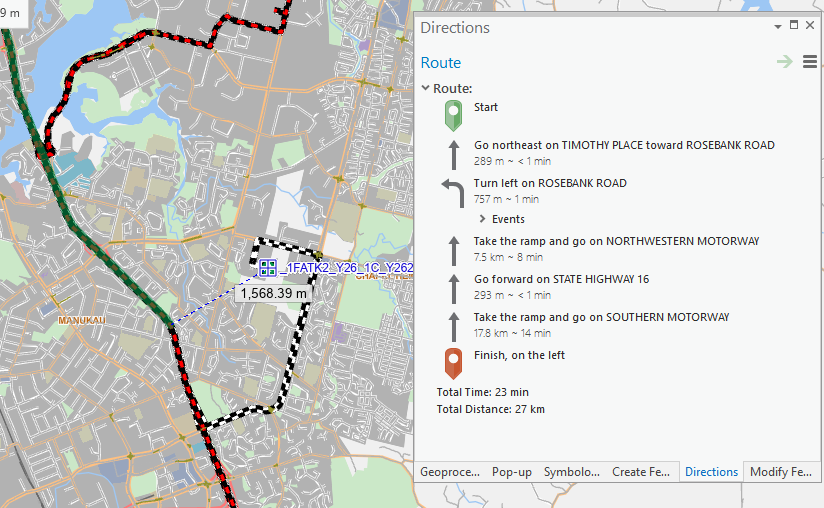
I need it to report an error here back to the user, not just end the route where it is.
I would have expected to be able to enter a "tolerance" value here somewhere that limited the "walking" distance at the end of the route to say 20 metres.
Apologies, in advance if this is a no-brainer question, I am very new to the world of ArcGIS
- Mark as New
- Bookmark
- Subscribe
- Mute
- Subscribe to RSS Feed
- Permalink
Hi,
I'm not sure if there's a built-in way to do it, but you could generate a buffer from your destination and check to see if your suggested route intersects it. You could also generate a Service Area for the walking distance and see if it intersects that.
- Mark as New
- Bookmark
- Subscribe
- Mute
- Subscribe to RSS Feed
- Permalink
Thanks David - I'll give the service area idea a go, I'm not sure the buffer approach will work for us, as we need to roll it out to clients' vehicles through ESRI Navigator. Will let you know how it goes.
- Mark as New
- Bookmark
- Subscribe
- Mute
- Subscribe to RSS Feed
- Permalink
When you add the stops locations to a route, the stops feature class has information on how they are from the street feature they are snapped to. You can limit the distance a stop searches out for the nearest routeable street in tools like Add Locations. Here is screen shot from a route in ArcGIS Pro and the related field values in the Stops attribute table.

Jay Sandhu
- Mark as New
- Bookmark
- Subscribe
- Mute
- Subscribe to RSS Feed
- Permalink
Wonderful Jay - this is is exactly what I was looking for. Do you know if it is possible to do a similar thing in ESRI Navigator on the mobile device? as that is what the end user will be doint.