- Home
- :
- All Communities
- :
- Products
- :
- Mapping and Charting Solutions
- :
- Mapping and Charting Questions
- :
- Need Assistance - First Time User
- Subscribe to RSS Feed
- Mark Topic as New
- Mark Topic as Read
- Float this Topic for Current User
- Bookmark
- Subscribe
- Mute
- Printer Friendly Page
- Mark as New
- Bookmark
- Subscribe
- Mute
- Subscribe to RSS Feed
- Permalink
Hello all,
I apologize for the basic nature of this question.
I am unable to call tech support and my boss gave me this program today to use for the first time, with a deadline of tomorrow for a zoning issue project.
I have several Excel spreadsheets with names and addresses in them. One is for retail stores, one for residential, etc.
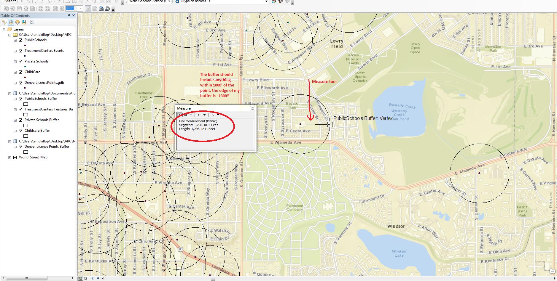
I need to figure out how to create a map of my city, and plot each point (300+) on the map, with a radius around each one. This needs to be fairly accurate to within a few feet (not sure if this is something my boss just wants or if it's even possible)
How do I do that with this program. I have searched online, but am at a loss.
Any information would be much appreciated.
Solved! Go to Solution.
- Mark as New
- Bookmark
- Subscribe
- Mute
- Subscribe to RSS Feed
- Permalink
I hate saying this - but I don't follow. ._.
EDIT/ADD: I'm even still trying to figure out how to re-do a buffer without starting over.
- Mark as New
- Bookmark
- Subscribe
- Mute
- Subscribe to RSS Feed
- Permalink
If your data is projected in a geographic coordinate system (lat/long), and not a projected coordinate system (UTM, for example), it could throw length measurements off. Also, if you made the buffers in one projection, and then changed it, or changed you data frame coordinate system so your data was being reprojected on the fly, it could also change the measurements. Unfortunately, you can't re-do a buffer, you just have to use the buffer tool again, but it's really not that much work. First step though, right click in the Table of contents where it says layers, select properties, and the coordinate system tab. Then right click your buffer dataset, and select properties, source tab, and scroll down so the coordinate system is visible. Report back what you find.
- Mark as New
- Bookmark
- Subscribe
- Mute
- Subscribe to RSS Feed
- Permalink
This should get you in the right direction:
http://hilo.hawaii.edu/~sdalhelp/docs/ht_reproject_shp.pdf
You will need to merge your point features into one layer (you can symbolize by different categories this way, still) and then reproject, then redo the buffers. It it's easier for you, you can also reproject each of your point layers, then redo the buffers for each one (how you have it set-up now).
You could choose something like NAD83 State Plane (Feet) for Colorado (probably central) in the "Projected" folder.
- Mark as New
- Bookmark
- Subscribe
- Mute
- Subscribe to RSS Feed
- Permalink
Allison, please do not use the Define Projection tool to change a projection, as it says in the document that Chris linked. This is for defining the original projection, not changing it, and will get you in a world of hurt if you use it that way.
- Mark as New
- Bookmark
- Subscribe
- Mute
- Subscribe to RSS Feed
- Permalink
Woops, the title of the article was "reproject" - that's what I get for assuming an .edu would give good info!
This .edu looks like it's really showing you how to reproject (follow the one for vector layers):
Reprojecting Coordinate Systems
Allison, if you accidentally used the define tool (sorry!) it's easy to get it back. Just use the define tool again and set it to WGS84 (the original coordinate system), but only do this if you went with my bad advice earlier!
- Mark as New
- Bookmark
- Subscribe
- Mute
- Subscribe to RSS Feed
- Permalink
Thanks, everyone. I am currently looking for a good tutorial/information source and will probably just start over, as I am not confident or happy with what I have done thus far.
- Mark as New
- Bookmark
- Subscribe
- Mute
- Subscribe to RSS Feed
- Permalink
Just to add to your learning Allison: data management is a very important part of ArcGIS. This includes knowing and planning where you store your files and analyses outputs, and starting with all your data in the same projection, and a projection that will work for the kind of analyses you are performing. Just keep that stuff in mind when reading and learning about ArcGIS. It is not enough to just use the tools. Good luck! I think you'll pick it up quickly considering how far you got in one day.
- Mark as New
- Bookmark
- Subscribe
- Mute
- Subscribe to RSS Feed
- Permalink
Thank you so much. That is actually the part that I wasn't liking on my current project - I am not confident in what I have done as far as data management, file naming, etc. goes.
- Mark as New
- Bookmark
- Subscribe
- Mute
- Subscribe to RSS Feed
- Permalink
Hey, good for you! Many people don't understand how important that stuff is right off the bat.