- Home
- :
- All Communities
- :
- Developers
- :
- JavaScript Maps SDK
- :
- JavaScript Maps SDK Questions
- :
- Re: WMTS layer is not being rendered in 4.17
- Subscribe to RSS Feed
- Mark Topic as New
- Mark Topic as Read
- Float this Topic for Current User
- Bookmark
- Subscribe
- Mute
- Printer Friendly Page
WMTS layer is not being rendered in 4.17
- Mark as New
- Bookmark
- Subscribe
- Mute
- Subscribe to RSS Feed
- Permalink
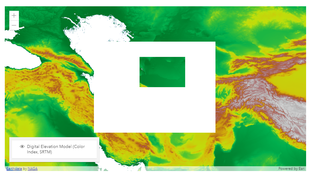
In JS API 4.17, WMTS layer is not being rendered correctly when the user zooms out, and it creates blank areas randomly. I can also see that this issue also exists even on your example map. WMTSLayer | ArcGIS API for JavaScript 4.17
I have confirmed that several users that they have the same problem.
JS Team, could you please provide a workaround/solution? It is blocking us. This issue does not exist in 4.16, but we have to use 4.17 because it has fixes for other problems that exist in 4.16.
I appreciate any help you can provide.

- Mark as New
- Bookmark
- Subscribe
- Mute
- Subscribe to RSS Feed
- Permalink
Hi Mete,
Thank you for reporting this. We are aware of this bug and have already fixed it for the upcoming release. You can test out this fix using https://js.arcgis.com/next in your app. Here's a codepen using /next with our WMTSLayer sample: https://codepen.io/annefitz/pen/GRqBpJr
Let me know if you are still seeing issues after testing with /next!
Thanks,
Anne
- Mark as New
- Bookmark
- Subscribe
- Mute
- Subscribe to RSS Feed
- Permalink
Hi,
Thanks for your response.
Unfortunately all of our maps rely on wmts layer so they all look pretty horrendous at the moment.
Is there not a way this could be fixed in the current API? Otherwise I guess we'll need to skip a version.
Thank you
- Mark as New
- Bookmark
- Subscribe
- Mute
- Subscribe to RSS Feed
- Permalink
Hello Anne,
Thanks for your prompt answer,
We will test it for sure and give feedback.
Could you share the time-line for the next release?
Regards,
- Mark as New
- Bookmark
- Subscribe
- Mute
- Subscribe to RSS Feed
- Permalink
Hello Anne,
We tested the next version with our WMTS services, I can confirm that is working now but we need to have this fix with 4.17 or 4.17.1 whatever you call for patches. This is a very fundamental feature that we cannot tolerate bugs. It is also a shame that ESRI is showcasing a bug in the example gallery.
Hope you understand the situation,
Regards,
- Mark as New
- Bookmark
- Subscribe
- Mute
- Subscribe to RSS Feed
- Permalink
Hi Mete,
I am very sorry that this issue you discovered is impacting your application, and thank you for reporting it to us so that we could resolve it.
Regarding your patch request: We don't patch the API unless we identify a critical security issue (for example introduced by a browser update). This is due to our very short development cycle between releases (we release every 3 months) - our teams are working hard to finish development and testing of the next release. In addition to the focus of our team, given the short release cycle, by the time we have a patch that is tested/validated for production, we are already nearing the next release. I hope that make sense. Please feel free to reach out to me directly if you would like to discuss this further (julie_powell@esri.com).
Version 4.18 is scheduled to go out on December 17th.
Thanks,
Julie