- Home
- :
- All Communities
- :
- Developers
- :
- JavaScript Maps SDK
- :
- JavaScript Maps SDK Questions
- :
- Re: Strange Popup Behavior with Multiple GP Tool L...
- Subscribe to RSS Feed
- Mark Topic as New
- Mark Topic as Read
- Float this Topic for Current User
- Bookmark
- Subscribe
- Mute
- Printer Friendly Page
Strange Popup Behavior with Multiple GP Tool Links
- Mark as New
- Bookmark
- Subscribe
- Mute
- Subscribe to RSS Feed
- Permalink
I'm working on a script with GP tools in a popup window. On click, the popup displays the lat/lon coordinates and two GP tool links. One of these is an ESRI sample tool that calculates population, the other generates a chart with a matplotlib script tool.
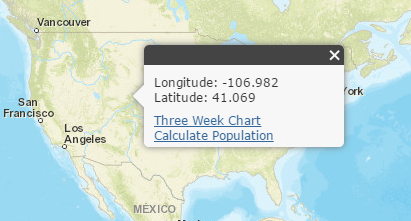
I'm getting some weird behavior with the inner HTML when I run the population tool. It says "calculating" Where it said "Three Week Chart," when "Calculate Population" should be replaced with "calculating" instead.
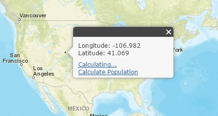
If I click on another point, I get this:

I'm not sure how to fix this. Here is the relevant portion of my script.
var locationStr = {};
var link = domConstruct.create("a",{
"class": "action",
"id": "statsLink",
"innerHTML": "Three Week Chart", //text that appears in the popup for the link
"href": "javascript: void(0);"
}, query(".actionList", map.infoWindow.domNode)[0]);
on(link, "click", function(){
domAttr.set(dom.byId("statsLink"), "innerHTML", "Generating Chart...");
window.gp_chart = new Geoprocessor("http://<ourserver>/arcgis/rest/services/Three_Week_Chart/GPServer/ThreeWeekChart");
var feature = window.map.infoWindow.getSelectedFeature();
var mp = webMercatorUtils.webMercatorToGeographic(feature.geometry);
var x = mp.x.toFixed(3);
var y = mp.y.toFixed(3);
var lat,lon = "";
lat = x.toString();
lon = y.toString();
locationStr = prompt("Enter Location Name", "Location", "Location");
var taskParams = {
"Latitude":lat,
"Longitude":lon,
"Location":locationStr
};
window.gp_chart.execute(taskParams,gpChartResultAvailable,gpChartFailure);
function gpChartResultAvailable(results, messages){
domAttr.set(dom.byId("statsLink"),"innerHTML", "Three Week Chart");
//clear any existing features displayed in the popup
window.map.infoWindow.clearFeatures();
var chart = "Three Week Chart"
var chartResult = chart.link("http://<ourserver>/Test_Charts/Three_Week_Chart_for_" + locationStr + ".png")
//display the query results
var content = "";
if(results == 0){
content = chartResult + "<br> for " + locationStr;
}else{
content = " Unable To Generate Chart";
}
window.map.infoWindow.setContent(content);
}
function gpChartFailure(error){
domAttr.set(dom.byId("statsLink"),"innerHTML", "Three Week Chart");
var details = domConstruct.create("div", {
"innerHTML": "Error: " + error
}, query(".break", window.map.infoWindow.domNode)[0],"after" );
console.error("Error occurred: ", error);
}
});
var link = domConstruct.create("a",{
"class": "action",
"id": "statsLink",
"innerHTML": "<br>Calculate Population", //text that appears in the popup for the link
"href": "javascript: void(0);"
}, query(".actionList", map.infoWindow.domNode)[0]);
on(link, "click", calculatePopulation);
window.gp = new Geoprocessor("http://sampleserver1.arcgisonline.com/ArcGIS/rest/services/Demographics/ESRI_Population_World/GPServ...");
function calculatePopulation(evt){
//display a message so user knows something is happening
domAttr.set(dom.byId("statsLink"), "innerHTML", "Calculating...");
//Get the feature associated with the displayed popup and use it as
//input to the geoprocessing task. The geoprocessing task will calculate
//population statistics for the area within the specified buffer distance.
var feature = window.map.infoWindow.getSelectedFeature();
var param = new BufferParameters();
param.geometries = [webMercatorUtils.webMercatorToGeographic(feature.geometry)];
var distance = prompt("Enter Search Radius","Kilometers", 10);
param.distances = [distance];
//param.distances = [10]; //buffer distance
param.unit = GeometryService.UNIT_KILOMETER;
param.bufferSpatialReference = new SpatialReference({"wkid": 4326});
param.outSpatialReference = new SpatialReference({"wkid": 102100});
param.geodesic = true;
esriConfig.defaults.geometryService.buffer(param, function(geometries){
var graphic = new Graphic(geometries[0]);
graphic.setSymbol(new SimpleFillSymbol().setColor(new Color([0,255,255,0.25])));
window.map.graphics.add(graphic);
//Use the buffered geometry as input to the GP task
var featureSet = new FeatureSet();
featureSet.geometryType = "esriGeometryPolygon";
featureSet.features = [graphic];
var taskParams = {
"inputPoly": featureSet
};
window.gp.execute(taskParams, gpPopResultAvailable, gpPopFailure);
});
}
function gpPopResultAvailable(results, messages){
domAttr.set(dom.byId("statsLink"),"innerHTML", "Calculate Population");
//clear any existing features displayed in the popup
window.map.infoWindow.clearFeatures();
var roundedPopulation = results[0].value.features[0].attributes.SUM;
//display the query results
var content = "";
if(results.length > 0){
content = "Population = " + roundedPopulation.toFixed(0);
}else{
content = "No Results Found";
}
window.map.infoWindow.setContent(content);
}
function gpPopFailure(error){
domAttr.set(dom.byId("statsLink"),"innerHTML", "Calculate Population");
var details = domConstruct.create("div", {
"innerHTML": "Population = " + error
}, query(".break", window.map.infoWindow.domNode)[0],"after" );
console.error("Error occurred: ", error);
}Solved! Go to Solution.
Accepted Solutions
- Mark as New
- Bookmark
- Subscribe
- Mute
- Subscribe to RSS Feed
- Permalink
Lloyd,
You are setting both of your popup actions with the id of statsLink. This will always be an issue creating multiple dom elements with the same id.
- Mark as New
- Bookmark
- Subscribe
- Mute
- Subscribe to RSS Feed
- Permalink
Lloyd,
You are setting both of your popup actions with the id of statsLink. This will always be an issue creating multiple dom elements with the same id.
- Mark as New
- Bookmark
- Subscribe
- Mute
- Subscribe to RSS Feed
- Permalink
Ah, duh. Thanks!
- Mark as New
- Bookmark
- Subscribe
- Mute
- Subscribe to RSS Feed
- Permalink
Don't forget to mark this question as answered by clicking on the "Correct Answer" link on the reply that answered your question.