Turn on suggestions
Auto-suggest helps you quickly narrow down your search results by suggesting possible matches as you type.
Cancel
- Home
- :
- All Communities
- :
- Developers
- :
- JavaScript Maps SDK
- :
- JavaScript Maps SDK Questions
- :
- programmatically check checkbox in toc widget
Options
- Subscribe to RSS Feed
- Mark Topic as New
- Mark Topic as Read
- Float this Topic for Current User
- Bookmark
- Subscribe
- Mute
- Printer Friendly Page
04-12-2013
12:43 PM
- Mark as New
- Bookmark
- Subscribe
- Mute
- Subscribe to RSS Feed
- Permalink
I am using the awesome toc widget, very new at arcgis and dojo and I am trying to check a checkbox on the toc widget when the user searches based on one of the layers.
For example, if the user searches based on "zip code", I would like to activate the zip code layer by checking the checkbox for "zip code" in the toc widget. I thought something like this (or some variation) would work:
dijit.byId("dijit_form_CheckBox_7").set("value",true);
dijit.byId("dijit_form_CheckBox_7").set("value","on");
<input type="checkbox" class="dijitReset dijitCheckBoxInput" data-dojo-attach-point="focusNode" data-dojo-attach-event="onclick:_onClick" value="on" tabindex="0" id="dijit_form_CheckBox_7" aria-checked="false" aria-disabled="false">
Also, if I succeed in checking the box, will this activate the widgets "onclick" event?
Can anyone help me with this? Thanks.
Solved! Go to Solution.
1 Solution
Accepted Solutions
04-24-2013
07:37 AM
- Mark as New
- Bookmark
- Subscribe
- Mute
- Subscribe to RSS Feed
- Permalink
I suggest watch firebug to see what's been sent to REST end point. If the request appears to be correct (i.e. layerIds and layerOptions are what you need), then there is a chance that the REST end point may ignore layerIds if the option is VISIBLE_LAYERS, you can try set it to ALL. (That's what I do to implement the functionality of only identify visible layers, although not use the JSAPI).
If after setting to ALL is still not getting your results, exam the group layers. Due to the fact that REST API does not handle "underfined", plus the true/false option can not be accurately represent a "partial" state (i.e. some layers in the group is visible), the REST API has to make some assumptions to deal with groups. That undocumented assumption can change between arcgis server versions, so test carefully.
What I can tell you is that the TOC widget force groups to be off (thus not sending them in "show:" to refresh dynamic layer). The reason been the rendering engineer will render every individual layer in a group regardless it's visibility state if it's parent is listed in the "show" list. If that's actually caused your identify problem, you may need to add those groups in the identifyParams. Again, this also could change between versions.
In summary, watch REST communication in firebug, test out how REST handle groups, you should be able to get what you want. There is no need to programmatically check the boxes. Just use dynalayer.visibleLayers.
5 Replies
04-23-2013
12:11 PM
- Mark as New
- Bookmark
- Subscribe
- Mute
- Subscribe to RSS Feed
- Permalink
Still bangin my head over this one, I do have the map published so it is can be viewed from the web
aecam map
My problem is simply this: I want provide identify information for only the layers that are checked in the TOC widget. My problem is I don't know how to identify which layers are checked to feed my identifyParams.layerIds.
It seems that if I use visibleLayers it gives me the info for all layers. Right now I am using a range of layers, but my thought is if I can tell which TOC box is checked, I can assign the layerIds to use after the map is clicked. This is also made with a kludge of examples from the site, so there may be an issue with that also. Can anyone help? Thanks
aecam map
My problem is simply this: I want provide identify information for only the layers that are checked in the TOC widget. My problem is I don't know how to identify which layers are checked to feed my identifyParams.layerIds.
identifyParams = new esri.tasks.IdentifyParameters();
identifyParams.tolerance = 3;
identifyParams.returnGeometry = true;
//identifyParams.layerIds = aecam.visibleLayers; //[0,5];
identifyParams.layerIds = [0,5];
identifyParams.layerOption = esri.tasks.IdentifyParameters.LAYER_OPTION_VISIBLE;
identifyParams.width  = map.width;
identifyParams.height = map.height;
It seems that if I use visibleLayers it gives me the info for all layers. Right now I am using a range of layers, but my thought is if I can tell which TOC box is checked, I can assign the layerIds to use after the map is clicked. This is also made with a kludge of examples from the site, so there may be an issue with that also. Can anyone help? Thanks
04-23-2013
12:51 PM
- Mark as New
- Bookmark
- Subscribe
- Mute
- Subscribe to RSS Feed
- Permalink
What I did in my app using the TOC widget was to set the identifyParams.layerIds in the executeIdentifyTask(evt) function.
Try using
Try using
function executeIdentifyTask(evt) {
    identifyParams.geometry = evt.mapPoint;
    identifyParams.mapExtent = map.extent;
    identifyParams.layerIds = aecam.visibleLayers;

    var deferred = identifyTask.execute(identifyParams);
04-24-2013
07:37 AM
- Mark as New
- Bookmark
- Subscribe
- Mute
- Subscribe to RSS Feed
- Permalink
I suggest watch firebug to see what's been sent to REST end point. If the request appears to be correct (i.e. layerIds and layerOptions are what you need), then there is a chance that the REST end point may ignore layerIds if the option is VISIBLE_LAYERS, you can try set it to ALL. (That's what I do to implement the functionality of only identify visible layers, although not use the JSAPI).
If after setting to ALL is still not getting your results, exam the group layers. Due to the fact that REST API does not handle "underfined", plus the true/false option can not be accurately represent a "partial" state (i.e. some layers in the group is visible), the REST API has to make some assumptions to deal with groups. That undocumented assumption can change between arcgis server versions, so test carefully.
What I can tell you is that the TOC widget force groups to be off (thus not sending them in "show:" to refresh dynamic layer). The reason been the rendering engineer will render every individual layer in a group regardless it's visibility state if it's parent is listed in the "show" list. If that's actually caused your identify problem, you may need to add those groups in the identifyParams. Again, this also could change between versions.
In summary, watch REST communication in firebug, test out how REST handle groups, you should be able to get what you want. There is no need to programmatically check the boxes. Just use dynalayer.visibleLayers.
If after setting to ALL is still not getting your results, exam the group layers. Due to the fact that REST API does not handle "underfined", plus the true/false option can not be accurately represent a "partial" state (i.e. some layers in the group is visible), the REST API has to make some assumptions to deal with groups. That undocumented assumption can change between arcgis server versions, so test carefully.
What I can tell you is that the TOC widget force groups to be off (thus not sending them in "show:" to refresh dynamic layer). The reason been the rendering engineer will render every individual layer in a group regardless it's visibility state if it's parent is listed in the "show" list. If that's actually caused your identify problem, you may need to add those groups in the identifyParams. Again, this also could change between versions.
In summary, watch REST communication in firebug, test out how REST handle groups, you should be able to get what you want. There is no need to programmatically check the boxes. Just use dynalayer.visibleLayers.
04-24-2013
08:35 AM
- Mark as New
- Bookmark
- Subscribe
- Mute
- Subscribe to RSS Feed
- Permalink
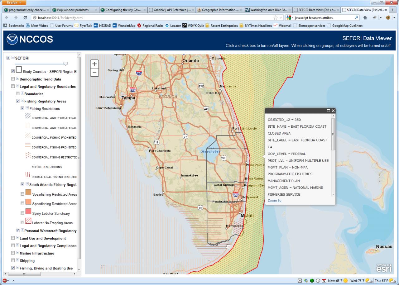
To show you an example of my previous post, this is what I get when I have use this code
[ATTACH=CONFIG]23740[/ATTACH]
When I comment the layerIds line out in the executeIdentifyTask function
I don't get a result back.
[ATTACH=CONFIG]23741[/ATTACH]
As an aside, Nianwei, the visibility toggle isn't working properly if there are more than two levels of groupings. As you can see, the top most layer group "Legal and Regulatory Boundaries" is turned off. This should mean that that layer "Fishing Restrictions" isn't visible. This map service is publicly available if you'd like to check it out.
            dojo.connect(map, "onClick", executeIdentifyTask);
            identifyTask = new esri.tasks.IdentifyTask("http://egisws02.nos.noaa.gov/ArcGIS/rest/services/biogeo/SEFCRI/MapServer");

            identifyParams = new esri.tasks.IdentifyParameters();
            identifyParams.tolerance = 3;
            identifyParams.returnGeometry = true;
            identifyParams.layerIds = layerSEFCRI.visibleLayers;
            identifyParams.layerOption = esri.tasks.IdentifyParameters.LAYER_OPTION_ALL;
            identifyParams.width = map.width;
            identifyParams.height = map.height;

        }

        function executeIdentifyTask(evt) {
            identifyParams.geometry = evt.mapPoint;
            identifyParams.mapExtent = map.extent;
            identifyParams.layerIds = layerSEFCRI.visibleLayers;
[ATTACH=CONFIG]23740[/ATTACH]
When I comment the layerIds line out in the executeIdentifyTask function
            dojo.connect(map, "onClick", executeIdentifyTask);
            identifyTask = new esri.tasks.IdentifyTask("http://egisws02.nos.noaa.gov/ArcGIS/rest/services/biogeo/SEFCRI/MapServer");

            identifyParams = new esri.tasks.IdentifyParameters();
            identifyParams.tolerance = 3;
            identifyParams.returnGeometry = true;
            identifyParams.layerIds = layerSEFCRI.visibleLayers;
            identifyParams.layerOption = esri.tasks.IdentifyParameters.LAYER_OPTION_ALL;
            identifyParams.width = map.width;
            identifyParams.height = map.height;

        }

        function executeIdentifyTask(evt) {
            identifyParams.geometry = evt.mapPoint;
            identifyParams.mapExtent = map.extent;
            //identifyParams.layerIds = layerSEFCRI.visibleLayers;
I don't get a result back.
[ATTACH=CONFIG]23741[/ATTACH]
As an aside, Nianwei, the visibility toggle isn't working properly if there are more than two levels of groupings. As you can see, the top most layer group "Legal and Regulatory Boundaries" is turned off. This should mean that that layer "Fishing Restrictions" isn't visible. This map service is publicly available if you'd like to check it out.
04-24-2013
09:10 AM
- Mark as New
- Bookmark
- Subscribe
- Mute
- Subscribe to RSS Feed
- Permalink
Thanks for all the replies, I am getting closer.
I did find out my problem with identifying the layers that are checked. instead of
I used
and I did place it inside my executeIdentifyTask(evt) function, thanks Ken for the suggestion.
Liu I will try out your suggestions.
I did find out my problem with identifying the layers that are checked. instead of
identifyParams.layerIds = map.visibleLayers;
I used
map._layers.aecam.visibleLayers;
and I did place it inside my executeIdentifyTask(evt) function, thanks Ken for the suggestion.
Liu I will try out your suggestions.