- Home
- :
- All Communities
- :
- Developers
- :
- JavaScript Maps SDK
- :
- JavaScript Maps SDK Questions
- :
- Re: problem get infomation directions router
- Subscribe to RSS Feed
- Mark Topic as New
- Mark Topic as Read
- Float this Topic for Current User
- Bookmark
- Subscribe
- Mute
- Printer Friendly Page
problem get infomation directions router
- Mark as New
- Bookmark
- Subscribe
- Mute
- Subscribe to RSS Feed
- Permalink
not get information points of router, returns Locattion 1, loacation2 ....
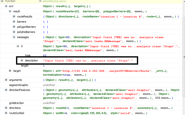
i use firebug get messages atribute of routeResults
| "Input field [field] was not mapped to a field in the network analysis class "Stops"." |
below image firebug
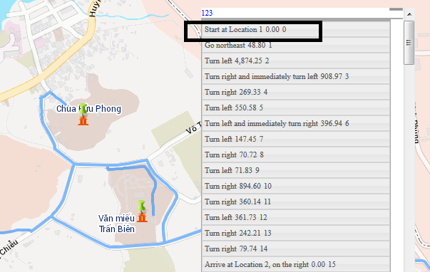
information direction:

my code:
$("#tuyen1").click(function () {
var routeTask, routeParams;
routeTask = new esri.tasks.RouteTask("http://localhost/arcgis/rest/services/NetworkanalystGT/NetworkanalystGT/NAServer/Route");
routeParams = new esri.tasks.RouteParameters();
routeParams.stops = new esri.tasks.FeatureSet();
routeParams.returnDirections = true;
routeParams.returnRoutes = true;
routeParams.routeName = true;
routeTask.on("solve-complete", showRoute);
routeTask.on("error", errorHandler);
var queryTaskstuyenDL = new esri.tasks.QueryTask(stringservice + "Bandochuyende/DULICH_03052015/MapServer/35");
var querytuyenDL = new esri.tasks.Query();
querytuyenDL.returnGeometry = true;
querytuyenDL.where = "upper(PHANLOAI_LUU) like 'ĐÌNH, CHÙA'";
querytuyenDL.outSpatialReference = myMap.spatialReference;
querytuyenDL.spatialRelationship = esri.tasks.Query.SPATIAL_REL_INTERSECTS;
queryTaskstuyenDL.execute(querytuyenDL, function (featureSet) {
myMap.graphics.clear();
var resultFeatures = featureSet.features;
if (resultFeatures.length > 0) {
for (var i = 0, il = resultFeatures.length; i < il; i++) {
var graphic = resultFeatures;
routeParams.stops.features.push(resultFeatures);
graphic.setSymbol(symbolmochc);
myMap.infoWindow.setFeatures([resultFeatures]);
myMap.graphics.add(graphic);
}
routeTask.solve(routeParams);
}
});
});
function showRoute(evt) {
var segmentGraphic;
var directions = evt.result.routeResults[0].directions;
var directionFeatures = directions.features;
var routeSymbol = new esri.symbol.SimpleLineSymbol().setColor(new dojo.Color([0, 120, 255, 0.5])).setWidth(4);
myMap.graphics.add(evt.result.routeResults[0].route.setSymbol(routeSymbol));
myMap.setExtent(directions.extent, true);
var directionsInfo = evt.result.routeResults[0].directions.features;
var totalDistance = dojo.number.format(directions.totalLength);
var totalLength = dojo.number.format(directions.totalTime);
data = dojo.map(directionsInfo, function (feature, index) {
return {
"detail": feature.attributes.text,
"distance": dojo.number.format(feature.attributes.length, { places: 2 }),
"index": index
}
});
var griddirection = new dgrid.Grid({
renderRow: renderList,
showHeader: true
}, "griddirection");
griddirection.renderArray(data);
griddirection.on(".dgrid-row:click", function (evt) {
var index = griddirection.row(evt).id;
var segment = directionFeatures[index];
var segmentSymbol = new esri.symbol.SimpleLineSymbol().setColor(new dojo.Color([255, 0, 00, 0.5])).setWidth(10);
myMap.setExtent(segment.geometry.getExtent(), true);
if (!segmentGraphic) {
segmentGraphic = myMap.graphics.add(new esri.Graphic(segment.geometry, segmentSymbol));
} else {
segmentGraphic.setGeometry(segment.geometry);
}
});
$('#griddirection').show();
$('#griddirection').draggable();
}
function errorHandler(err) {
alert("An error occured\n" + err.message + "\n");
}
- Mark as New
- Bookmark
- Subscribe
- Mute
- Subscribe to RSS Feed
- Permalink
Ia,
Some things to check.
Did your query return a result? If no results are returned, then no stops will be created. Or there may be too many stops for a route to be solved.
Are the stops using the same spatial reference as the route network used? If they are not, the stops won't be close enough to the route's street network to be considered a stop point.
Regards,
Tom
- Mark as New
- Bookmark
- Subscribe
- Mute
- Subscribe to RSS Feed
- Permalink
Thanks Tom!
My query return a few points
yes, i use router netwword, i was showed points and router, i not show points address in results direction
i displayed direction of the router, but instead of displaying the specific points address, Then the results returned is the location1, locattion2 in the directions
- Mark as New
- Bookmark
- Subscribe
- Mute
- Subscribe to RSS Feed
- Permalink
Ia,
To get the stop name to appear you must assign it as you add the stop. It would be ideal if when you added a stop that it would find a "Name" field and use it for your stop location name. To solve this problem, I created an stop object to use for each feature and explicitly added a stop name.
  // add the selected stops
  arrayUtil.forEach(selectedGraphicsLayer.graphics, function(feature, i) {
       var a = feature.attributes;
       // make a stop so we have name and XY
       var stop = {
            name: a.Name,
            feature: {
                 geometry: {
                      x: feature.geometry.x,
                      y: feature.geometry.y
                 },
                 attributes: a
       }
  };
  directions.addStop(stop);
  });
  directions.getDirections();
This example was from a craft beverage tour where the app user can select which locations they would like to visit and create driving directions. You can view this example at: Craft Beverage Tour Please view source to see how I manage the stops for this app.
I hope this helps!
Regards,
Tom
- Mark as New
- Bookmark
- Subscribe
- Mute
- Subscribe to RSS Feed
- Permalink
Thank you! my code worked
- Mark as New
- Bookmark
- Subscribe
- Mute
- Subscribe to RSS Feed
- Permalink
La,
don't forget to mark the right answer.
Tim