- Home
- :
- All Communities
- :
- Developers
- :
- JavaScript Maps SDK
- :
- JavaScript Maps SDK Questions
- :
- Re: keep dijit menuitem open after select
- Subscribe to RSS Feed
- Mark Topic as New
- Mark Topic as Read
- Float this Topic for Current User
- Bookmark
- Subscribe
- Mute
- Printer Friendly Page
- Mark as New
- Bookmark
- Subscribe
- Mute
- Subscribe to RSS Feed
- Permalink
I have a table of contents (TOC) with a legend that allows me to turn on/off layer in my map. I placed my the TOC in a dijit menubar across the top of my page. When I make a selection from the TOC to turn on/off a layer, I want the TOC to stay opened, but it closes immediately after I select a layer. Any ideas ?
Solved! Go to Solution.
- Mark as New
- Bookmark
- Subscribe
- Mute
- Subscribe to RSS Feed
- Permalink
Brain,
Sure here is a sample:
<!DOCTYPE html>
<html>

<head>
    <meta http-equiv="Content-Type" content="text/html; charset=utf-8">
    <meta name="viewport" content="initial-scale=1, maximum-scale=1,user-scalable=no" />
    <title>TOC</title>
    <link rel="stylesheet" type="text/css" href="https://js.arcgis.com/3.17/dijit/themes/claro/claro.css">
    <link rel="stylesheet" type="text/css" href="https://js.arcgis.com/3.17/esri/css/esri.css" />
    <link rel="stylesheet" type="text/css" href="agsjs/dijit/css/TOC.css" />
    <style>
        html,
        body {
            height: 98%;
            width: 98%;
            margin: 0;
            padding: 5px;
            font-family: helvetica, arial, sans-serif;
            font-size: 90%;
        }

        #header {
            position: fixed;
            top: 0;
            width: 100%;
            height: 50px;
            left: 0;
            background: silver;
        }

        #content {
            position: fixed;
            top: 32px;
            width: 100%;
            height: 100%;
            left: 0;
            margin: 0;
            border: 0;
        }

        #footer {
            position: fixed;
            bottom: 0;
            width: 100%;
            height: 35px;
            left: 0;
            background: silver;
        }

        #map {
            position: fixed;
            width: 100%;
            height: 100%;
            border: 0;
            margin-left: -15px;
            margin-top: -15px;
            margin-right: -15px;
        }

        #tocDiv {
          background-color: silver;
          padding: 8px;
          overflow: auto;
          max-width: 600px;
          max-height: 500px;
        }

        .IdentifyIcon {
            background-image: url("images/Identify.png");
            background-repeat: no-repeat;
            width: 18px;
            height: 18px;
            text-align: center;
        }

        .FindIcon {
            background-image: url("images/query.png");
            background-repeat: no-repeat;
            width: 18px;
            height: 18px;
            text-align: center;
        }

        .claro .dijitButton .dijitButtonNode,
        .claro .dijitDropDownButton .dijitButtonNode,
        .claro .dijitComboButton .dijitButtonNode,
        .claro .dijitToggleButton .dijitButtonNode {
            border: 0;
            padding: 2px 4px 4px 4px;
            color: #000000;
            border-radius: 0;
            box-shadow: none;
            background: none;
        }

        .claro .dijitMenu {
            background-color: silver;
            border: 1px solid gray;
        }
    </style>
    <script type="text/javascript">
        var djConfig = {
            paths: {
                agsjs: "/js/agsjs"
            }
        };
    </script>
    <script src="https://js.arcgis.com/3.17/"></script>

    <script type="text/javascript">
        var map, toc, basemap, dynaLayer1, dynaLayer2;
        require([
            "dojo/dom",
            "dojo/parser",
            "dojo/on",
            "dojo/_base/lang",
            "esri/map",
            "esri/geometry/Extent",
            "esri/layers/ArcGISTiledMapServiceLayer",
            "esri/layers/ArcGISDynamicMapServiceLayer",
            "agsjs/dijit/TOC",
            "dijit/form/DropDownButton",
            "dijit/DropDownMenu",
            "dijit/MenuItem",
            "dijit/layout/BorderContainer",
            "dijit/layout/ContentPane",
            "dojo/domReady!"
        ], function(dom, parser, on, lang,
            Map, Extent, ArcGISTiledMapServiceLayer, ArcGISDynamicMapServiceLayer,
            TOC, DropDownButton, DropDownMenu, MenuItem) {
            parser.parse();
            var initialExtent = new Extent({
                xmin: -8119646.38042271,
                ymin: 4986891.42830988,
                xmax: -8102329.13378822,
                ymax: 4999699.14992532,
                "spatialReference": {
                    "wkid": 102100
                }
            });
            map = new Map("map", {
                extent: initialExtent,
                smartNavigation: false,
                slider: false
            });
            basemap = new ArcGISTiledMapServiceLayer("http://server.arcgisonline.com/ArcGIS/rest/services/World_Street_Map/MapServer");
            map.addLayer(basemap);
            dynaLayer1 = new ArcGISDynamicMapServiceLayer("http://sampleserver6.arcgisonline.com/arcgis/rest/services/NapervilleShelters/MapServer", {
                opacity: 0.8
            });
            dynaLayer2 = new ArcGISDynamicMapServiceLayer("http://sampleserver6.arcgisonline.com/arcgis/rest/services/LocalGovernment/Recreation/MapServer", {
                opacity: 0.8
            });

            var h = map.on('LayersAddResult', lang.hitch(this, function(results) {
                dynaLayer1.setVisibleLayers([0]);
                dynaLayer2.setVisibleLayers([0, 1]);

                try {
                    toc = new TOC({
                        map: map,
                        layerInfos: [{
                            layer: dynaLayer1,
                            title: "Contaminated Areas",
                            collapsed: true,
                            slider: false
                        }, {
                            layer: dynaLayer2,
                            title: "Other Constraints",
                            collapsed: true,
                            slider: false
                        }]
                    }, 'tocDiv');
                    toc.startup();
                    toc.on('load', function() {});
                    toc.on('TOCNodeChecked', function(rootLayer, serviceLayer, checked) {});
                    h.remove();
                    var myButton = new DropDownButton({
                        label: "Map Feature List",
                        dropDown: toc
                    });
                    dom.byId("header").appendChild(myButton.domNode);

                    var menu = new DropDownMenu({ style: "display: none;"});
                    var menuItem1 = new MenuItem({
                        label: "Identify Feature",
                        iconClass:"IdentifyIcon",
                        onClick: function(){ alert('Identify'); }
                    });
                    var menuItem2 = new MenuItem({
                        label: "Find Building",
                        iconClass:"FindIcon",
                        onClick: function(){ alert('Find'); }
                    });
                    menu.addChild(menuItem1);
                    menu.addChild(menuItem2);
                    var myButton2 = new DropDownButton({
                        label: "Identify Tools",
                        dropDown: menu
                    });

                    dom.byId("header").appendChild(myButton2.domNode);
                } catch (e) {
                    alert(e);
                }
            }));
            map.addLayers([dynaLayer1, dynaLayer2]);
        });
    </script>
</head>

<body class="claro">
    <div id="content" data-dojo-type="dijit/layout/BorderContainer" design="headline" gutters="true">
        <div id="tocDiv" style="display: none;"></div>
        <div id="header"></div>
        <div id="map" data-dojo-type="dijit/layout/ContentPane" region="center"></div>
    </div>
    <div id="footer"></div>
</body>

</html>
- Mark as New
- Bookmark
- Subscribe
- Mute
- Subscribe to RSS Feed
- Permalink
Geez Robert that was quick.
As I was thrown into the deep end on this project, with very little experience, your help is greatly appreciated.
- Mark as New
- Bookmark
- Subscribe
- Mute
- Subscribe to RSS Feed
- Permalink
Robert,
Do you know how to change the font size for the layer title in the TOC ?
Brian
- Mark as New
- Bookmark
- Subscribe
- Mute
- Subscribe to RSS Feed
- Permalink
Brian,
What Ken is talking about is (for example in Chrome) you would right click on the layer title in the TOC and choose "Inspect", which would bring up the browsers developer tools and select the span element
<span data-dojo-attach-point="labelNode" class="agsjsTOCRootLayerLabel">Contaminated Areas</span>
Then you would look at the class attribute and see that it is assigned "agsjsTOCRootLayerLabel" then you look for the css rule and file that the rule is coming from (see image):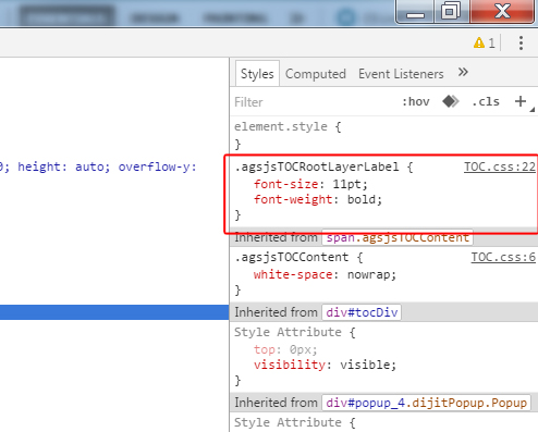
Now you know you need to look in the TOC.css line 22 to find this css rule and edit it.
- Mark as New
- Bookmark
- Subscribe
- Mute
- Subscribe to RSS Feed
- Permalink
Robert,
I just looked at that now. That is extremely helpful. Thanks.
Brian
- « Previous
-
- 1
- 2
- Next »
- « Previous
-
- 1
- 2
- Next »