- Home
- :
- All Communities
- :
- Developers
- :
- JavaScript Maps SDK
- :
- JavaScript Maps SDK Questions
- :
- Identify infowindow missing "zoom to" & highlight
- Subscribe to RSS Feed
- Mark Topic as New
- Mark Topic as Read
- Float this Topic for Current User
- Bookmark
- Subscribe
- Mute
- Printer Friendly Page
Identify infowindow missing "zoom to" & highlight
- Mark as New
- Bookmark
- Subscribe
- Mute
- Subscribe to RSS Feed
- Permalink
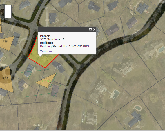
I try to identify a parcel and return results on the same infowindow but missing a "Zoom to" link and can't figure out how to highlight a parcel only.
I put the code here:
Hope someone can show me what I am missing...
Thanks.
Solved! Go to Solution.
Accepted Solutions
- Mark as New
- Bookmark
- Subscribe
- Mute
- Subscribe to RSS Feed
- Permalink
for some reason formatting was completely off in my previous post.
            function showIdentifyResults(r, tasks) {
                var results = [];
                var taskUrls = [];
                r = dojo.filter(r, function (result) {
                    return r[0];
                });
                for (i = 0; i < r.length; i++) {
                    results = results.concat(r);
                    for (j = 0; j < r.length; j++) {
                        taskUrls = taskUrls.concat(tasks.url);
                    }
                }


  //combine content -------------------
   var content = parcels = buildings ="";
              var parcelFeatures = [];
   dojo.forEach(results, function(result) {
    var feature = result.feature;
  var atts = feature.attributes;
  feature.attributes.layerName = result.layerName;
  if(result.layerName === 'Tax Parcels'){
   parcels += atts["Postal Address"] + "<br />";
                  parcelFeatures[parcelFeatures.length] = result.feature;
  }
  else if (result.layerName === 'Building Footprints'){
   buildings += "Building/Parcel ID: " + atts.PARCELID + "<br />";
  }

   });
  if ( parcels ) {
  content += "<b>Parcels</b><br />" + parcels;
   }
   if ( buildings ) {
  content += "<b>Buildings</b><br />" + buildings;
   }
   console.log("content:  ", content);
   map.infoWindow.setTitle("Parcel Information");

   map.infoWindow.setContent(content);
   //map.infoWindow.show(idPoint);


    if (results.length === 0) {
                    map.infoWindow.clearFeatures();
                } else {
                     map.infoWindow.setFeatures(parcelFeatures);
                     map.infoWindow.setContent(content);
                }
                map.infoWindow.show(idPoint);
                return results;

            }
- Mark as New
- Bookmark
- Subscribe
- Mute
- Subscribe to RSS Feed
- Permalink
May Jeff,
You will not get the zoom to or feature highlight without setting the infoWindows.setFeatures method. More like this sample: Display identify results in popup | ArcGIS API for JavaScript
- Mark as New
- Bookmark
- Subscribe
- Mute
- Subscribe to RSS Feed
- Permalink
if I set the infoWindows like this -
map.infoWindow.setFeatures(results);
Nothing shows up anymore. Can you show me on the JSFiddle? Thanks.
- Mark as New
- Bookmark
- Subscribe
- Mute
- Subscribe to RSS Feed
- Permalink
Thanks for your sample. Eventhough I define the layerName I want, but it still shows up all layers. Can you show me how to exclusive some layer names?
Thanks.
- Mark as New
- Bookmark
- Subscribe
- Mute
- Subscribe to RSS Feed
- Permalink
Actually I try to identify multiple map services with certain layer names with their attributes to show up in ONE page infoWindow and then only highlight parcel polygon.
I only find out I can use content to do it but won't highlight any result at all based on the Robert mentioned above - NEED map.infoWindow.setFeatures(results). I used the sample you all shows on JSFiddle, I can't show all attributes information in one page. What do I need to modify it so can show all results in one page?
Thank you for your time.
- Mark as New
- Bookmark
- Subscribe
- Mute
- Subscribe to RSS Feed
- Permalink
Hi Jeff,
If below is the result you are looking for combined info result with zoom to.

Below is your modified showIdentifyResults (inserted lines 17, 24, 47)
            function showIdentifyResults(r, tasks) {
                var results = [];
                var taskUrls = [];
                r = dojo.filter(r, function (result) {
                    return r[0];
                });
                for (i = 0; i < r.length; i++) {
                    results = results.concat(r);
                    for (j = 0; j < r.length; j++) {
                        taskUrls = taskUrls.concat(tasks.url);
                    }
                }


  //combine content -------------------
   var content = parcels = buildings ="";
              var parcelFeatures = [];
   dojo.forEach(results, function(result) {
    var feature = result.feature;
  var atts = feature.attributes;
  feature.attributes.layerName = result.layerName;
  if(result.layerName === 'Tax Parcels'){
   parcels += atts["Postal Address"] + "<br />";
                  parcelFeatures[parcelFeatures.length] = result.feature;
  }
  else if (result.layerName === 'Building Footprints'){
   buildings += "Building/Parcel ID: " + atts.PARCELID + "<br />";
  }

   });
  if ( parcels ) {
  content += "<b>Parcels</b><br />" + parcels;
   }
   if ( buildings ) {
  content += "<b>Buildings</b><br />" + buildings;
   }
   console.log("content:  ", content);
   map.infoWindow.setTitle("Parcel Information");

   map.infoWindow.setContent(content);
   //map.infoWindow.show(idPoint);


    if (results.length === 0) {
                    map.infoWindow.clearFeatures();
                } else {
                     map.infoWindow.setFeatures(parcelFeatures);
                     map.infoWindow.setContent(content);
                }
                map.infoWindow.show(idPoint);
                return results;

            }
- Mark as New
- Bookmark
- Subscribe
- Mute
- Subscribe to RSS Feed
- Permalink
for some reason formatting was completely off in my previous post.
            function showIdentifyResults(r, tasks) {
                var results = [];
                var taskUrls = [];
                r = dojo.filter(r, function (result) {
                    return r[0];
                });
                for (i = 0; i < r.length; i++) {
                    results = results.concat(r);
                    for (j = 0; j < r.length; j++) {
                        taskUrls = taskUrls.concat(tasks.url);
                    }
                }


  //combine content -------------------
   var content = parcels = buildings ="";
              var parcelFeatures = [];
   dojo.forEach(results, function(result) {
    var feature = result.feature;
  var atts = feature.attributes;
  feature.attributes.layerName = result.layerName;
  if(result.layerName === 'Tax Parcels'){
   parcels += atts["Postal Address"] + "<br />";
                  parcelFeatures[parcelFeatures.length] = result.feature;
  }
  else if (result.layerName === 'Building Footprints'){
   buildings += "Building/Parcel ID: " + atts.PARCELID + "<br />";
  }

   });
  if ( parcels ) {
  content += "<b>Parcels</b><br />" + parcels;
   }
   if ( buildings ) {
  content += "<b>Buildings</b><br />" + buildings;
   }
   console.log("content:  ", content);
   map.infoWindow.setTitle("Parcel Information");

   map.infoWindow.setContent(content);
   //map.infoWindow.show(idPoint);


    if (results.length === 0) {
                    map.infoWindow.clearFeatures();
                } else {
                     map.infoWindow.setFeatures(parcelFeatures);
                     map.infoWindow.setContent(content);
                }
                map.infoWindow.show(idPoint);
                return results;

            }
- Mark as New
- Bookmark
- Subscribe
- Mute
- Subscribe to RSS Feed
- Permalink
Thank you very much. This is what I need.