- Home
- :
- All Communities
- :
- Developers
- :
- JavaScript Maps SDK
- :
- JavaScript Maps SDK Questions
- :
- Re: How to add shapefile without ArcGIS Online?
- Subscribe to RSS Feed
- Mark Topic as New
- Mark Topic as Read
- Float this Topic for Current User
- Bookmark
- Subscribe
- Mute
- Printer Friendly Page
- Mark as New
- Bookmark
- Subscribe
- Mute
- Subscribe to RSS Feed
- Permalink
Refering to this sample, I can do the things as expected. However, my ArcGIS Server and client PC cannot go to the internet, so can I setup the same thing in my intranet environment or can I just simply enable it in my ArcGIS manager? Thanks.
Solved! Go to Solution.
Accepted Solutions
- Mark as New
- Bookmark
- Subscribe
- Mute
- Subscribe to RSS Feed
- Permalink
Use Leaflet.js map with leaflet.shapefile at calvinmetcalf/leaflet.shapefile · GitHub it requires shapefile JS. Then you create a map as in the code below. In the zip I have 4 shapefiles with points and polygons. And you can use ESRI's leaflet plugin for their other stuff if you want. I am over the ESRI JavaScript API - I hate DOJO. It's like they love huge things like Flex and Silverlight and now DOJO for all the fancy widgets. Pretty over functional.
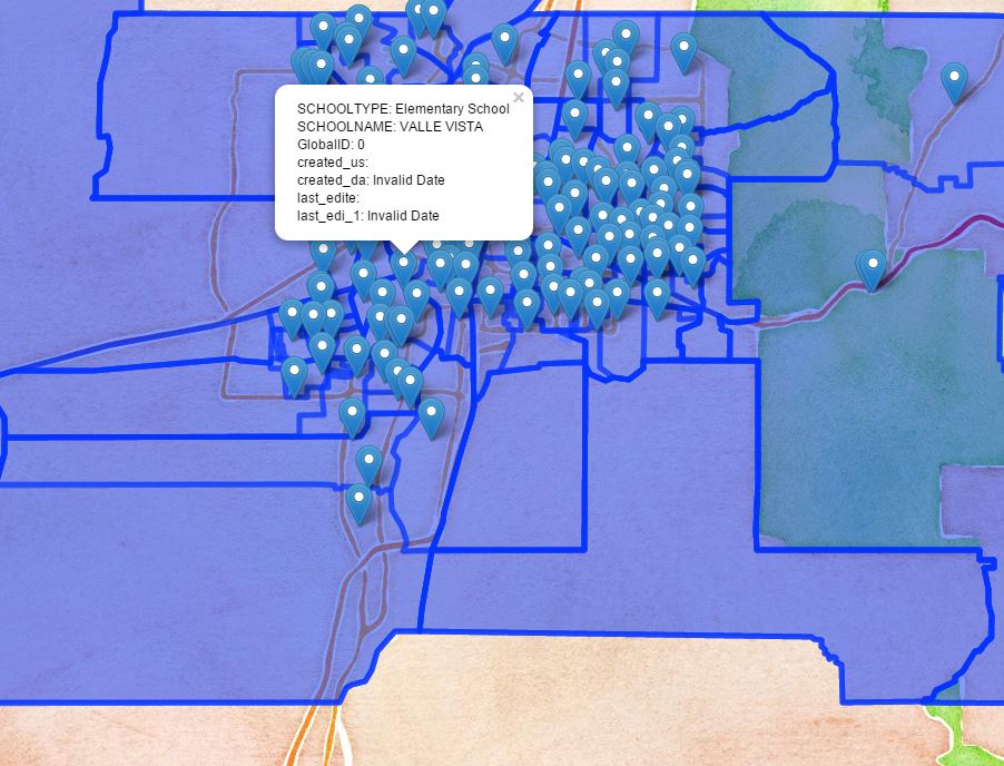
var m = L.map('map').setView([ 35.10418, -106.62987],8);
var watercolor = L.tileLayer('http://{s}.tile.stamen.com/watercolor/{z}/{x}/{y}.jpg',{attribution:'Map tiles by <a href="http://stamen.com">Stamen Design</a>, <a href="http://creativecommons.org/licenses/by/3.0">CC BY 3.0</a> — Map data © <a href="http://openstreetmap.org">OpenStreetMap</a> contributors, <a href="http://creativecommons.org/licenses/by-sa/2.0/">CC-BY-SA</a>'}).addTo(m);
var shpfile = new L.Shapefile('apsschools.zip',{onEachFeature:function(feature, layer) {
if (feature.properties) {
layer.bindPopup(Object.keys(feature.properties).map(function(k){
return k + ": " + feature.properties
}).join("<br />"),{maxHeight:200});
}
}});
shpfile.addTo(m);
shpfile.once("load", function(){
console.log("finished loading shapefile");
});
- Mark as New
- Bookmark
- Subscribe
- Mute
- Subscribe to RSS Feed
- Permalink
You might be able to use this library:
- Mark as New
- Bookmark
- Subscribe
- Mute
- Subscribe to RSS Feed
- Permalink
Thanks for your reply! Is this written in Node.js? I am not sure if I can setup the Node.js in my servers, but is there any other library, server object extension or sample to do the same thing also?
- Mark as New
- Bookmark
- Subscribe
- Mute
- Subscribe to RSS Feed
- Permalink
Stephen,
you can always host the javascript API locally.
See the last paragraph here: Get the ArcGIS API for JavaScript | Guide | ArcGIS API for JavaScript
Hope this helps!
Tim
- Mark as New
- Bookmark
- Subscribe
- Mute
- Subscribe to RSS Feed
- Permalink
I didn't notice it was designed for Node.js.
There are other JavaScript libraries for shapefiles on GitHub, though.
Based on its documentation it looks like shapefile-js is designed to work in a browser.
- Mark as New
- Bookmark
- Subscribe
- Mute
- Subscribe to RSS Feed
- Permalink
Use Leaflet.js map with leaflet.shapefile at calvinmetcalf/leaflet.shapefile · GitHub it requires shapefile JS. Then you create a map as in the code below. In the zip I have 4 shapefiles with points and polygons. And you can use ESRI's leaflet plugin for their other stuff if you want. I am over the ESRI JavaScript API - I hate DOJO. It's like they love huge things like Flex and Silverlight and now DOJO for all the fancy widgets. Pretty over functional.
var m = L.map('map').setView([ 35.10418, -106.62987],8);
var watercolor = L.tileLayer('http://{s}.tile.stamen.com/watercolor/{z}/{x}/{y}.jpg',{attribution:'Map tiles by <a href="http://stamen.com">Stamen Design</a>, <a href="http://creativecommons.org/licenses/by/3.0">CC BY 3.0</a> — Map data © <a href="http://openstreetmap.org">OpenStreetMap</a> contributors, <a href="http://creativecommons.org/licenses/by-sa/2.0/">CC-BY-SA</a>'}).addTo(m);
var shpfile = new L.Shapefile('apsschools.zip',{onEachFeature:function(feature, layer) {
if (feature.properties) {
layer.bindPopup(Object.keys(feature.properties).map(function(k){
return k + ": " + feature.properties
}).join("<br />"),{maxHeight:200});
}
}});
shpfile.addTo(m);
shpfile.once("load", function(){
console.log("finished loading shapefile");
});
- Mark as New
- Bookmark
- Subscribe
- Mute
- Subscribe to RSS Feed
- Permalink
Thanks Paul, It works! Can this API convert the geometry based on my coordinate system of shape file?
I also don't like DOJO as it is huge size and slow performance....
- Mark as New
- Bookmark
- Subscribe
- Mute
- Subscribe to RSS Feed
- Permalink
My shapefile is in state plane and it converted automatically. If you want to read it back in the original projection, use something like proj4js.
- Mark as New
- Bookmark
- Subscribe
- Mute
- Subscribe to RSS Feed
- Permalink
hey paul, thanks for the codes, it works like a charm
but how to change the outline of the shapefile? like how to customize it to another color and change it from watercolor to a better outline
hope you can help, thanks