- Home
- :
- All Communities
- :
- Developers
- :
- JavaScript Maps SDK
- :
- JavaScript Maps SDK Questions
- :
- Re: Disable ESRI World Geocoder from Search Bar
- Subscribe to RSS Feed
- Mark Topic as New
- Mark Topic as Read
- Float this Topic for Current User
- Bookmark
- Subscribe
- Mute
- Printer Friendly Page
- Mark as New
- Bookmark
- Subscribe
- Mute
- Subscribe to RSS Feed
- Permalink
I am using the Search multiple sources | ArcGIS API for JavaScript code to create a search bar than can be changed to search multiple attributes.
My project is over a small area and it is unnecessary and unwanted to have the geolocator as a search option or even as the default option on the drop down.
My question is, How can I disable this so that it is not either 1)an option under the search bar or 2) not the default search.
Thanks!
Solved! Go to Solution.
Accepted Solutions
- Mark as New
- Bookmark
- Subscribe
- Mute
- Subscribe to RSS Feed
- Permalink
Yeap - try this sample:
ArcGIS API for JavaScript Sandbox
Use this code:
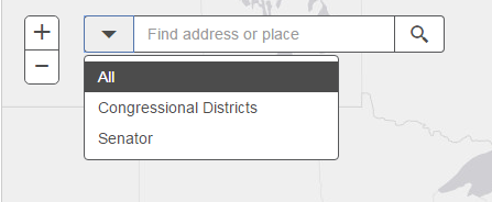
<!DOCTYPE html>
<html dir="ltr">


   <link rel="stylesheet" href="http://js.arcgis.com/3.14/esri/css/esri.css">


<head>
   <meta http-equiv="Content-Type" content="text/html; charset=utf-8">
   <meta name="viewport" content="initial-scale=1, maximum-scale=1,user-scalable=no" />
   <title>ArcGIS API for JavaScript | Search widget with multiple sources</title>
   <link rel="stylesheet" href="http://js.arcgis.com/3.14/dijit/themes/claro/claro.css">
   <link rel="stylesheet" href="http://js.arcgis.com/3.14/esri/css/esri.css">
   <style>
      html,
      body,
      #map {
         height: 100%;
         width: 100%;
         margin: 0;
         padding: 0;
      }
      #search {
         display: block;
         position: absolute;
         z-index: 2;
         top: 20px;
         left: 74px;
      }
   </style>


   </script>
<script src="http://js.arcgis.com/3.14/"></script>
   <script>
      require([
        "esri/map", "esri/dijit/Search", "esri/layers/FeatureLayer", "esri/InfoTemplate", "dojo/domReady!"
      ], function (Map, Search, FeatureLayer, InfoTemplate) {
         var map = new Map("map", {
            basemap: "gray",
            center: [-97, 38], // lon, lat
            zoom: 5
         });


         var s = new Search({
            enableButtonMode: true, //this enables the search widget to display as a single button
            enableLabel: false,
            enableInfoWindow: true,
            showInfoWindowOnSelect: false,
            map: map
         }, "search");


         //var sources = s.get("sources");
         var sources = [];


         //Push the sources used to search, by default the ArcGIS Online World geocoder is included. In addition there is a feature layer of US congressional districts. The districts search is set up to find the "DISTRICTID". Also, a feature layer of senator information is set up to find based on the senator name.


         sources.push({
            featureLayer: new FeatureLayer("http://services.arcgis.com/V6ZHFr6zdgNZuVG0/arcgis/rest/services/CongressionalDistricts/FeatureServe..."),
            searchFields: ["DISTRICTID"],
            displayField: "DISTRICTID",
            exactMatch: false,
            outFields: ["DISTRICTID", "NAME", "PARTY"],
            name: "Congressional Districts",
            placeholder: "3708",
            maxResults: 6,
            maxSuggestions: 6,


            //Create an InfoTemplate and include three fields
            infoTemplate: new InfoTemplate("Congressional District", "District ID: ${DISTRICTID}</br>Name: ${NAME}</br>Party Affiliation: ${PARTY}"),
            enableSuggestions: true,
            minCharacters: 0
         });


         sources.push({
            featureLayer: new FeatureLayer("http://services.arcgis.com/V6ZHFr6zdgNZuVG0/arcgis/rest/services/US_Senators/FeatureServer/0"),
            searchFields: ["Name"],
            displayField: "Name",
            exactMatch: false,
            name: "Senator",
            outFields: ["*"],
            placeholder: "Senator name",
            maxResults: 6,
            maxSuggestions: 6,


            //Create an InfoTemplate


            infoTemplate: new InfoTemplate("Senator information", "Name: ${Name}</br>State: ${State}</br>Party Affiliation: ${Party}</br>Phone No: ${Phone_Number}<br><a href=${Web_Page} target=_blank ;'>Website</a>"),

            enableSuggestions: true,
            minCharacters: 0
         });


         //Set the sources above to the search widget
         s.set("sources", sources);


         s.startup();


      });
   </script>
</head>


<body>
   <div id="search"></div>
   <div id="map"></div>
</body>


</html>
I set the sources var to an empty array and just pushed the ones explicitly added; not the ones inherently available on construction. Alternatively, you can keep the original sample and just set the sources constructor property to an empty array, or to your sources:
         var s = new Search({
            enableButtonMode: true, //this enables the search widget to display as a single button
            enableLabel: false,
            enableInfoWindow: true,
            showInfoWindowOnSelect: false,
            map: map,
            sources: []
         }, "search");


         var sources = s.get("sources");
- Mark as New
- Bookmark
- Subscribe
- Mute
- Subscribe to RSS Feed
- Permalink
Yeap - try this sample:
ArcGIS API for JavaScript Sandbox
Use this code:
<!DOCTYPE html>
<html dir="ltr">


   <link rel="stylesheet" href="http://js.arcgis.com/3.14/esri/css/esri.css">


<head>
   <meta http-equiv="Content-Type" content="text/html; charset=utf-8">
   <meta name="viewport" content="initial-scale=1, maximum-scale=1,user-scalable=no" />
   <title>ArcGIS API for JavaScript | Search widget with multiple sources</title>
   <link rel="stylesheet" href="http://js.arcgis.com/3.14/dijit/themes/claro/claro.css">
   <link rel="stylesheet" href="http://js.arcgis.com/3.14/esri/css/esri.css">
   <style>
      html,
      body,
      #map {
         height: 100%;
         width: 100%;
         margin: 0;
         padding: 0;
      }
      #search {
         display: block;
         position: absolute;
         z-index: 2;
         top: 20px;
         left: 74px;
      }
   </style>


   </script>
<script src="http://js.arcgis.com/3.14/"></script>
   <script>
      require([
        "esri/map", "esri/dijit/Search", "esri/layers/FeatureLayer", "esri/InfoTemplate", "dojo/domReady!"
      ], function (Map, Search, FeatureLayer, InfoTemplate) {
         var map = new Map("map", {
            basemap: "gray",
            center: [-97, 38], // lon, lat
            zoom: 5
         });


         var s = new Search({
            enableButtonMode: true, //this enables the search widget to display as a single button
            enableLabel: false,
            enableInfoWindow: true,
            showInfoWindowOnSelect: false,
            map: map
         }, "search");


         //var sources = s.get("sources");
         var sources = [];


         //Push the sources used to search, by default the ArcGIS Online World geocoder is included. In addition there is a feature layer of US congressional districts. The districts search is set up to find the "DISTRICTID". Also, a feature layer of senator information is set up to find based on the senator name.


         sources.push({
            featureLayer: new FeatureLayer("http://services.arcgis.com/V6ZHFr6zdgNZuVG0/arcgis/rest/services/CongressionalDistricts/FeatureServe..."),
            searchFields: ["DISTRICTID"],
            displayField: "DISTRICTID",
            exactMatch: false,
            outFields: ["DISTRICTID", "NAME", "PARTY"],
            name: "Congressional Districts",
            placeholder: "3708",
            maxResults: 6,
            maxSuggestions: 6,


            //Create an InfoTemplate and include three fields
            infoTemplate: new InfoTemplate("Congressional District", "District ID: ${DISTRICTID}</br>Name: ${NAME}</br>Party Affiliation: ${PARTY}"),
            enableSuggestions: true,
            minCharacters: 0
         });


         sources.push({
            featureLayer: new FeatureLayer("http://services.arcgis.com/V6ZHFr6zdgNZuVG0/arcgis/rest/services/US_Senators/FeatureServer/0"),
            searchFields: ["Name"],
            displayField: "Name",
            exactMatch: false,
            name: "Senator",
            outFields: ["*"],
            placeholder: "Senator name",
            maxResults: 6,
            maxSuggestions: 6,


            //Create an InfoTemplate


            infoTemplate: new InfoTemplate("Senator information", "Name: ${Name}</br>State: ${State}</br>Party Affiliation: ${Party}</br>Phone No: ${Phone_Number}<br><a href=${Web_Page} target=_blank ;'>Website</a>"),

            enableSuggestions: true,
            minCharacters: 0
         });


         //Set the sources above to the search widget
         s.set("sources", sources);


         s.startup();


      });
   </script>
</head>


<body>
   <div id="search"></div>
   <div id="map"></div>
</body>


</html>
I set the sources var to an empty array and just pushed the ones explicitly added; not the ones inherently available on construction. Alternatively, you can keep the original sample and just set the sources constructor property to an empty array, or to your sources:
         var s = new Search({
            enableButtonMode: true, //this enables the search widget to display as a single button
            enableLabel: false,
            enableInfoWindow: true,
            showInfoWindowOnSelect: false,
            map: map,
            sources: []
         }, "search");


         var sources = s.get("sources");
- Mark as New
- Bookmark
- Subscribe
- Mute
- Subscribe to RSS Feed
- Permalink
WONDERFUL!, Thank You so much!