Turn on suggestions
Auto-suggest helps you quickly narrow down your search results by suggesting possible matches as you type.
Cancel
- Home
- :
- All Communities
- :
- Developers
- :
- JavaScript Maps SDK
- :
- JavaScript Maps SDK Questions
- :
- Re: Adding Editor Widget to a Tab
Options
- Subscribe to RSS Feed
- Mark Topic as New
- Mark Topic as Read
- Float this Topic for Current User
- Bookmark
- Subscribe
- Mute
- Printer Friendly Page
04-10-2012
04:18 PM
- Mark as New
- Bookmark
- Subscribe
- Mute
- Subscribe to RSS Feed
- Permalink
I can take the editor example and get it working. I can also get it working in my existing application when I just throw it in a ContentPane (IT WORKS) - like this:
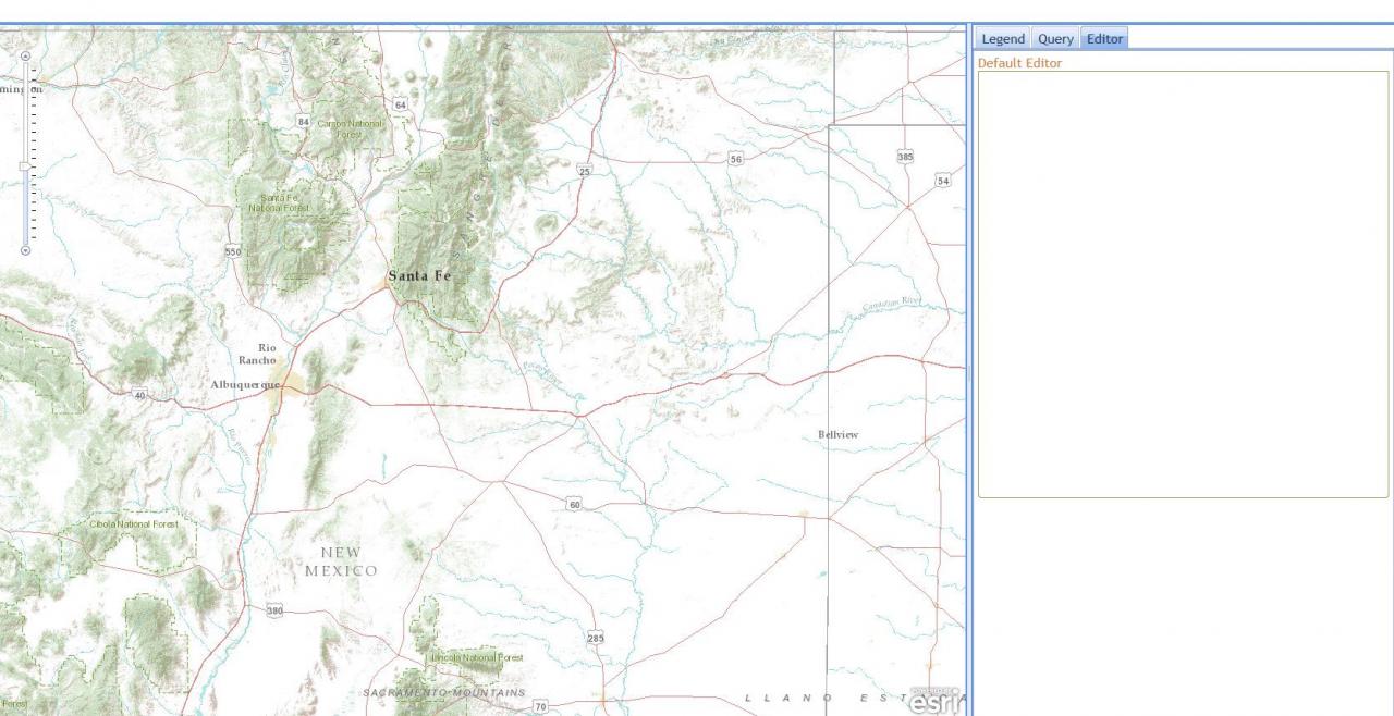
But when I try to add it to my custom ContentPane / TabContainer the boarder show up but my feature class symbols (template picker/icons) don't show up...Like This
What I'm I doing wrong...I think it is the code in RED.
Thanks
Nathalie.
<div data-dojo-type="dijit.layout.ContentPane" id="testPane" data-dojo-props="region:'left'">
        <!--div id="panelHeader">
          Default Editor
        </div-->
        <div style="padding:10px;" id="editorDiv">
        </div>
      </div>
But when I try to add it to my custom ContentPane / TabContainer the boarder show up but my feature class symbols (template picker/icons) don't show up...Like This
<div dojotype="dijit.layout.ContentPane" id="rightPane" region="right" splitter="true">
        <div dojotype="dijit.layout.TabContainer">
          <div dojotype="dijit.layout.ContentPane" title="Legend" selected="true">
            Content for the first tab
          </div>
          <div dojotype="dijit.layout.ContentPane" title="Query">
            Content for the second tab
          </div>
          <div dojotype="dijit.layout.ContentPane" title="Editor" >
            <div style="padding:10px;" id="editorDiv">
          </div>
        </div>
      </div>
What I'm I doing wrong...I think it is the code in RED.
Thanks
Nathalie.
Solved! Go to Solution.
1 Solution
Accepted Solutions
04-13-2012
08:34 AM
- Mark as New
- Bookmark
- Subscribe
- Mute
- Subscribe to RSS Feed
- Permalink
Nathalie,
You need to create the editor widget the first time the tab is displayed. You can do this by listening for the tab's onShow event. This event is fired when users click on the tab. When this happens you'll create the editor. Here's a modified version of the sample that demonstrates this. Note that once the tab is clicked once we disconnect the event so the editor doesn't get created more than once.
You need to create the editor widget the first time the tab is displayed. You can do this by listening for the tab's onShow event. This event is fired when users click on the tab. When this happens you'll create the editor. Here's a modified version of the sample that demonstrates this. Note that once the tab is clicked once we disconnect the event so the editor doesn't get created more than once.
<!DOCTYPE HTML PUBLIC "-//W3C//DTD HTML 4.01//EN" "http://www.w3.org/TR/html4/strict.dtd"> <html> <head> <meta http-equiv="Content-Type" content="text/html; charset=utf-8"> <meta http-equiv="X-UA-Compatible" content="IE=7, IE=9" /> <!--The viewport meta tag is used to improve the presentation and behavior of the samples on iOS devices--> <meta name="viewport" content="initial-scale=1, maximum-scale=1,user-scalable=no"/> <title> </title> <link rel="stylesheet" type="text/css" href="http://serverapi.arcgisonline.com/jsapi/arcgis/2.8/js/dojo/dijit/themes/claro/claro.css"> <link rel="stylesheet" type="text/css" href="http://serverapi.arcgisonline.com/jsapi/arcgis/2.8/js/esri/dijit/css/Popup.css"> <style type="text/css"> html,body { height:100%; width:100%; margin:0; } body { background-color:#FFF; overflow:hidden; font-family:"Trebuchet MS"; } #header { border:solid 4px #224a54; color:#000; font-size:18pt; text-align:left; font-weight:700; height:70px; margin:2px; } #subtitle { font-size:small; color:#FFF; padding-left:20px; } #rightPane { background-color:#FFF; color:#3f3f3f; border:solid 2px #224a54; width:20%; } #leftPane { background-color:#FFF; color:#3f3f3f; border:solid 2px #224a54; width:20%; margin:5px; padding:2px; } #map { border:solid 4px #224a54; -moz-border-radius:4px; -webkit-border-radius:4px; border-radius:4px; margin:5px; } #footer { border:solid 2px #224a54; background-color:#ecefe4; color:#3f3f3f; font-size:10pt; text-align:center; height:40px; margin:2px; } .dijitTabInnerDiv { background-color:#ecefe4; } #tabs { padding:5px; } </style> <script type="text/javascript"> var dojoConfig = { parseOnLoad: true }; </script> <script type="text/javascript" src="http://serverapi.arcgisonline.com/jsapi/arcgis/?v=2.8"> </script> <script type="text/javascript"> dojo.require("dijit.dijit"); // optimize: load dijit layer dojo.require("dijit.layout.BorderContainer"); dojo.require("dijit.layout.ContentPane"); dojo.require("esri.map"); dojo.require("esri.arcgis.utils"); dojo.require("esri.IdentityManager"); dojo.require("dijit.layout.TabContainer"); dojo.require("esri.dijit.editing.Editor-all"); var map; var editorSettings; function init() { //snapping is enabled for this sample - change the tooltip to reflect this esri.bundle.toolbars.draw.start = esri.bundle.toolbars.draw.start + "<br/>Press <b>CTRL</b> to enable snapping"; esri.bundle.toolbars.draw.addPoint = esri.bundle.toolbars.draw.addPoint + "<br/>Press <b>CTRL</b> to enable snapping"; //This sample requires a proxy page to handle communications with the ArcGIS Server services. You will need to //replace the url below with the location of a proxy on your machine. See the 'Using the proxy page' help topic //for details on setting up a proxy page. esri.config.defaults.io.proxyUrl = "/arcgisserver/apis/javascript/proxy/proxy.ashx"; //This service is for development and testing purposes only. We recommend that you create your own geometry service for use within your applications esri.config.defaults.geometryService = new esri.tasks.GeometryService("http://tasks.arcgisonline.com/ArcGIS/rest/services/Geometry/GeometryServer"); var extent = new esri.geometry.Extent({ "xmin": -8576501, "ymin": 4705377, "xmax": -8574612, "ymax": 4706867, "spatialReference": { "wkid": 102100 } }); map = new esri.Map("map", { extent: extent }); dojo.connect(map, "onLoad", function() { //resize the map when the browser resizes dojo.connect(dijit.byId('map'), 'resize', map,map.resize); }); dojo.connect(map, "onLayersAddResult", initEditing); var basemap = new esri.layers.ArcGISTiledMapServiceLayer("http://server.arcgisonline.com/ArcGIS/rest/services/World_Topo_Map/MapServer"); map.addLayer(basemap); var operationsPointLayer = new esri.layers.FeatureLayer("http://sampleserver3.arcgisonline.com/ArcGIS/rest/services/HomelandSecurity/operations/FeatureServer/0", { mode: esri.layers.FeatureLayer.MODE_ONDEMAND, outFields: ["*"] }); var operationsLineLayer = new esri.layers.FeatureLayer("http://sampleserver3.arcgisonline.com/ArcGIS/rest/services/HomelandSecurity/operations/FeatureServer/1", { mode: esri.layers.FeatureLayer.MODE_ONDEMAND, outFields: ["*"] }); var operationsPolygonLayer = new esri.layers.FeatureLayer("http://sampleserver3.arcgisonline.com/ArcGIS/rest/services/HomelandSecurity/operations/FeatureServer/2", { mode: esri.layers.FeatureLayer.MODE_ONDEMAND, outFields: ["*"] }); map.addLayers([operationsPointLayer, operationsPolygonLayer, operationsLineLayer]); map.infoWindow.resize(400, 300); } function initEditing(results) { var featureLayerInfos = dojo.map(results, function(result) { return { 'featureLayer': result.layer }; }); editorSettings = { map: map, layerInfos: featureLayerInfos }; //when the editor tab is clicked we'll initialize the editor var showHandler = dojo.connect(dijit.byId('editTab'),'onShow',function(evt){ //disconnect the handler so the editor is only initialized once dojo.disconnect(showHandler); var params = { settings: editorSettings }; var editorWidget = new esri.dijit.editing.Editor(params, 'editorDiv'); editorWidget.startup(); }); } dojo.addOnLoad(init); </script> </head> <body class="claro"> <div id="mainWindow" data-dojo-type="dijit.layout.BorderContainer" data-dojo-props="design:'headline'" style="width:100%; height:100%;"> <div id="header" data-dojo-type="dijit.layout.ContentPane" data-dojo-props="region:'top'"> <div id="title"> </div> </div> <div data-dojo-type="dijit.layout.TabContainer" data-dojo-props='region:"left"' id='leftPane'> <div data-dojo-type="dijit.layout.ContentPane" data-dojo-props="title:'Tab 1', selected:'true'"> Content for the first tab </div> <div id='editTab' data-dojo-type="dijit.layout.ContentPane" data-dojo-props="title:'Edit'"> <div id='editorDiv'></div> </div> </div> <div id="map" data-dojo-type="dijit.layout.ContentPane" data-dojo-props="region:'center'"> </div> <div id="footer" data-dojo-type="dijit.layout.ContentPane" data-dojo-props="region:'bottom'"> <span id="dataSource"> </span> </div> </div> </body> </html>
5 Replies
04-12-2012
08:44 AM
- Mark as New
- Bookmark
- Subscribe
- Mute
- Subscribe to RSS Feed
- Permalink
I need to try and move on to my next task...can someone please respond...be kind and I will give you the credit/points you deserve
Here's basically what I'm trying to do:
Take this web layout example - http://help.arcgis.com/en/webapi/javascript/arcgis/help/jssamples_start.htm#jssamples/ags_mapcontain...
then add in the Editor example - http://help.arcgis.com/en/webapi/javascript/arcgis/help/jssamples_start.htm#jssamples/ags_mapcontain...
PLEASE SOMEONE show me how to add the editor widget (pick icon list) to Tab 2
Thanks
Desperate Nathalie
04-12-2012
03:19 PM
- Mark as New
- Bookmark
- Subscribe
- Mute
- Subscribe to RSS Feed
- Permalink
I just figured out my code is fine...well kind of. If my editor tab is the first tab or the default then it works so I guess I need to figure out how to refresh/recall/reload the different tabs when a tab is changed because I don't want this to be my default tab. Any help would be greatly appreciated
 <div dojoType="dijit.layout.ContentPane" id="editorPane" title="Editor" id="editorPane" selected="true">
            <div id="editorDiv"></div>
          </div>
04-13-2012
08:34 AM
- Mark as New
- Bookmark
- Subscribe
- Mute
- Subscribe to RSS Feed
- Permalink
Nathalie,
You need to create the editor widget the first time the tab is displayed. You can do this by listening for the tab's onShow event. This event is fired when users click on the tab. When this happens you'll create the editor. Here's a modified version of the sample that demonstrates this. Note that once the tab is clicked once we disconnect the event so the editor doesn't get created more than once.
You need to create the editor widget the first time the tab is displayed. You can do this by listening for the tab's onShow event. This event is fired when users click on the tab. When this happens you'll create the editor. Here's a modified version of the sample that demonstrates this. Note that once the tab is clicked once we disconnect the event so the editor doesn't get created more than once.
<!DOCTYPE HTML PUBLIC "-//W3C//DTD HTML 4.01//EN" "http://www.w3.org/TR/html4/strict.dtd"> <html> <head> <meta http-equiv="Content-Type" content="text/html; charset=utf-8"> <meta http-equiv="X-UA-Compatible" content="IE=7, IE=9" /> <!--The viewport meta tag is used to improve the presentation and behavior of the samples on iOS devices--> <meta name="viewport" content="initial-scale=1, maximum-scale=1,user-scalable=no"/> <title> </title> <link rel="stylesheet" type="text/css" href="http://serverapi.arcgisonline.com/jsapi/arcgis/2.8/js/dojo/dijit/themes/claro/claro.css"> <link rel="stylesheet" type="text/css" href="http://serverapi.arcgisonline.com/jsapi/arcgis/2.8/js/esri/dijit/css/Popup.css"> <style type="text/css"> html,body { height:100%; width:100%; margin:0; } body { background-color:#FFF; overflow:hidden; font-family:"Trebuchet MS"; } #header { border:solid 4px #224a54; color:#000; font-size:18pt; text-align:left; font-weight:700; height:70px; margin:2px; } #subtitle { font-size:small; color:#FFF; padding-left:20px; } #rightPane { background-color:#FFF; color:#3f3f3f; border:solid 2px #224a54; width:20%; } #leftPane { background-color:#FFF; color:#3f3f3f; border:solid 2px #224a54; width:20%; margin:5px; padding:2px; } #map { border:solid 4px #224a54; -moz-border-radius:4px; -webkit-border-radius:4px; border-radius:4px; margin:5px; } #footer { border:solid 2px #224a54; background-color:#ecefe4; color:#3f3f3f; font-size:10pt; text-align:center; height:40px; margin:2px; } .dijitTabInnerDiv { background-color:#ecefe4; } #tabs { padding:5px; } </style> <script type="text/javascript"> var dojoConfig = { parseOnLoad: true }; </script> <script type="text/javascript" src="http://serverapi.arcgisonline.com/jsapi/arcgis/?v=2.8"> </script> <script type="text/javascript"> dojo.require("dijit.dijit"); // optimize: load dijit layer dojo.require("dijit.layout.BorderContainer"); dojo.require("dijit.layout.ContentPane"); dojo.require("esri.map"); dojo.require("esri.arcgis.utils"); dojo.require("esri.IdentityManager"); dojo.require("dijit.layout.TabContainer"); dojo.require("esri.dijit.editing.Editor-all"); var map; var editorSettings; function init() { //snapping is enabled for this sample - change the tooltip to reflect this esri.bundle.toolbars.draw.start = esri.bundle.toolbars.draw.start + "<br/>Press <b>CTRL</b> to enable snapping"; esri.bundle.toolbars.draw.addPoint = esri.bundle.toolbars.draw.addPoint + "<br/>Press <b>CTRL</b> to enable snapping"; //This sample requires a proxy page to handle communications with the ArcGIS Server services. You will need to //replace the url below with the location of a proxy on your machine. See the 'Using the proxy page' help topic //for details on setting up a proxy page. esri.config.defaults.io.proxyUrl = "/arcgisserver/apis/javascript/proxy/proxy.ashx"; //This service is for development and testing purposes only. We recommend that you create your own geometry service for use within your applications esri.config.defaults.geometryService = new esri.tasks.GeometryService("http://tasks.arcgisonline.com/ArcGIS/rest/services/Geometry/GeometryServer"); var extent = new esri.geometry.Extent({ "xmin": -8576501, "ymin": 4705377, "xmax": -8574612, "ymax": 4706867, "spatialReference": { "wkid": 102100 } }); map = new esri.Map("map", { extent: extent }); dojo.connect(map, "onLoad", function() { //resize the map when the browser resizes dojo.connect(dijit.byId('map'), 'resize', map,map.resize); }); dojo.connect(map, "onLayersAddResult", initEditing); var basemap = new esri.layers.ArcGISTiledMapServiceLayer("http://server.arcgisonline.com/ArcGIS/rest/services/World_Topo_Map/MapServer"); map.addLayer(basemap); var operationsPointLayer = new esri.layers.FeatureLayer("http://sampleserver3.arcgisonline.com/ArcGIS/rest/services/HomelandSecurity/operations/FeatureServer/0", { mode: esri.layers.FeatureLayer.MODE_ONDEMAND, outFields: ["*"] }); var operationsLineLayer = new esri.layers.FeatureLayer("http://sampleserver3.arcgisonline.com/ArcGIS/rest/services/HomelandSecurity/operations/FeatureServer/1", { mode: esri.layers.FeatureLayer.MODE_ONDEMAND, outFields: ["*"] }); var operationsPolygonLayer = new esri.layers.FeatureLayer("http://sampleserver3.arcgisonline.com/ArcGIS/rest/services/HomelandSecurity/operations/FeatureServer/2", { mode: esri.layers.FeatureLayer.MODE_ONDEMAND, outFields: ["*"] }); map.addLayers([operationsPointLayer, operationsPolygonLayer, operationsLineLayer]); map.infoWindow.resize(400, 300); } function initEditing(results) { var featureLayerInfos = dojo.map(results, function(result) { return { 'featureLayer': result.layer }; }); editorSettings = { map: map, layerInfos: featureLayerInfos }; //when the editor tab is clicked we'll initialize the editor var showHandler = dojo.connect(dijit.byId('editTab'),'onShow',function(evt){ //disconnect the handler so the editor is only initialized once dojo.disconnect(showHandler); var params = { settings: editorSettings }; var editorWidget = new esri.dijit.editing.Editor(params, 'editorDiv'); editorWidget.startup(); }); } dojo.addOnLoad(init); </script> </head> <body class="claro"> <div id="mainWindow" data-dojo-type="dijit.layout.BorderContainer" data-dojo-props="design:'headline'" style="width:100%; height:100%;"> <div id="header" data-dojo-type="dijit.layout.ContentPane" data-dojo-props="region:'top'"> <div id="title"> </div> </div> <div data-dojo-type="dijit.layout.TabContainer" data-dojo-props='region:"left"' id='leftPane'> <div data-dojo-type="dijit.layout.ContentPane" data-dojo-props="title:'Tab 1', selected:'true'"> Content for the first tab </div> <div id='editTab' data-dojo-type="dijit.layout.ContentPane" data-dojo-props="title:'Edit'"> <div id='editorDiv'></div> </div> </div> <div id="map" data-dojo-type="dijit.layout.ContentPane" data-dojo-props="region:'center'"> </div> <div id="footer" data-dojo-type="dijit.layout.ContentPane" data-dojo-props="region:'bottom'"> <span id="dataSource"> </span> </div> </div> </body> </html>
04-16-2012
10:37 AM
- Mark as New
- Bookmark
- Subscribe
- Mute
- Subscribe to RSS Feed
- Permalink
Thanks Kelly,
That was it...I thought I need to call it but wasn't sure on how...I'm still really new to JS and writing code in general. I was hoping to maybe ask you one more question.
I'm going to have a few other tabs (ex. Legend, Query, Editing, Other) and I would like to separate the code for each tab...so maybe have separate JS files for each one so I can re-use them and so I don't have one huge "layout.js" file. My question is there a easy way to do this...call another JS file within my layout.js file. Could you point me to something that describes this or maybe so me?
Thanks again.
Nathalie.